the Creative Commons Attribution 4.0 License.
the Creative Commons Attribution 4.0 License.
 | 03 Nov 2025
IODP3–NSF Expedition 501 “New England Shelf Hydrogeology” Scientific Prospectus
Karen Johannesson
Jeremy Everest
In many coastal settings worldwide, the distribution of freshwater within continental shelf sediments is far out of equilibrium with modern sea level. One of the most remarkable examples is found on the Atlantic continental shelf off New England where groundwater within shallow Pliocene-Pleistocene sand aquifers over 100 km offshore has low salinity (3000 mg L−1 or less). On Nantucket Island, a 514 m deep borehole penetrating the entire Cretaceous–Tertiary sedimentary package shows considerable variations in salinity with fresh (<1000 mg L−1) water in sand aquifers, higher salinity (30 %–70 % of seawater) in thick clay and/or silt layers, and intermediate-to-low salinity in thin confining units. Integrated Ocean Drilling Program Expeditions 313 (New Jersey Shallow Shelf) and 317 (Canterbury Basin New Zealand) also showed abrupt offshore freshwater–saltwater boundaries linked to lithology. This demonstrates the disequilibrium nature of such systems; diffusion tends to eliminate such patterns. Pore fluid within Pleistocene to upper Cretaceous sands beneath Nantucket Island are also found to be modestly overpressured at ∼ 4 m relative to the local water table. We hypothesise that the rapid incursion of freshened water on the continental shelf in New England could have been caused by one or more of the following mechanisms: (1) meteoric recharge during Pleistocene sea-level lowstands, including vertical infiltration of freshwater associated with local flow cells on the shelf; (2) sub-ice-sheet recharge during the Last Glacial Maximum; and (3) recharge from pro-glacial lakes. We further hypothesise that the overpressures could be due to (1) Pleistocene sediment loading or (2) fluid density differences associated with emplacement of a thick freshwater lens over saltwater (analogous to excess pressures in the gas legs of petroleum reservoirs). We argue these different recharge mechanisms and overpressure models can be distinguished through drilling, coring, logging, and fluid sampling. Noble gas and environmental isotope data will be necessary to completely evaluate recharge models. This work will extend our understanding of the current and past states of fluid composition, pressure, and temperature in continental shelf environments. It will help better constrain rates, directions, and mechanisms of groundwater flow and chemical fluxes in continental shelf systems. It will contribute to the development of new tools for measuring freshened water in marine environments. The apparent transient nature of continental shelf salinity patterns could have important implications for microbial processes and long-term fluxes of carbon, nitrogen, and other nutrients to the ocean. Successful drilling will test process-based models for shelf freshwater off New England. These models can then be applied to other shelf freshwater systems around the world.
- Article
(4708 KB) - Full-text XML
- BibTeX
- EndNote


Expedition 501 is based on International Ocean Discovery Program (IODP) drilling proposal 637-Full2 and addenda 637-Add3, -Add7, and -Add8. Following ranking by the IODP Science Advisory Structure, the expedition was scheduled by the European Consortium for Ocean Research Drilling (ECORD) facility board as a mission-specific platform (MSP) expedition, to be implemented by the ECORD science operator (ESO). The expedition is scheduled from 1 May to a latest end date of 14 August 2025, with a total of 105 d available for the drilling, coring, and downhole measurements described in this report and on the ESO Expedition 501 web page (https://www.ecord.org/expedition501/, last access: 3 June 2025). The onshore operations (ONO) in Bremen are provisionally scheduled to start in January 2026 and last for a maximum of 4 weeks (dependent on core recovery).
The following links should be used in conjunction with this scientific prospectus:
-
The Expedition 501 web page will be periodically updated with expedition-specific information on the platform, facilities, coring strategy, measurement plan, and schedule. The full proposal and addenda can be accessed at https://www.ecord.org/expedition501/ (last access: 3 June 2025).
-
General details about the offshore facilities provided by ESO are provided on the ESO-specific web pages on the MARUM website (https://www.marum.de/en/Offshore-core-curation-and-measurements-2.html, last access: 3 June 2025).
-
General details about the onshore facilities provided by ESO are provided on the ESO-specific web pages on the MARUM website (https://www.marum.de/Onshore-Science-Party-OSP.html, last access: 3 June 2025).
-
The supporting site survey data for Expedition 501 are archived in the IODP Site Survey Data Bank (https://ssdb.iodp.org/, last access: 3 June 2025). Please note that not all site survey data associated with this expedition are publicly available.
Coastal hydrological systems are important as they provide significant freshwater to coastal communities around the world. These resources are typically extracted by groundwater wells that produce from unconfined or confined aquifers with well screen depths of less than 100 m. In 2000, coastal groundwater production along the US Atlantic and Pacific coastlines was about 19.5 km3 (Barlow and Reichard, 2010). To put this number in perspective, this represents about 2.4 % of annual global groundwater withdraws of 800 km3 yr−1 (Konikow and Kendy, 2005). Sea-level rise poses a unique issue to coastal freshwater sustainability (Werner and Simmons, 2009; Werner et al., 2013). In this context, offshore freshened groundwater (OFG) systems that occur within continental shelves below sea level are of particular interest. The global occurrence of this offshore fresh and brackish groundwater along coastlines (Post et al., 2013) (Fig. 1) is volumetrically significant but not a well-studied potential reserve for an increasing coastal population. Additionally, coastal freshwater resources are particularly susceptible to contamination due to their proximity to seawater (Post, 2005). To date, the residence times of OFG systems are unknown. This leads to questions including those of whether they were emplaced during the Last Glacial Maximum (LGM) or whether they represent some long-term average of Pleistocene lowstand sea-level conditions? Of further interest is a potential hydraulic connection to onshore meteorically recharged systems (Michael and Khan, 2016). It is currently unclear whether groundwater offshore New England is replenished through long-timescale flow paths through permeable crystalline basement rocks that crop out on the mainland or if these systems represent non-renewable reserves decoupled from the modern, active hydrologic cycle. As coastal populations continue to increase and sea level rises, stresses on these potential resources will also increase. It is therefore crucial to understand the hydrodynamics of these systems to characterise their extent, to establish their relation to equilibrium conditions, and to define their potential as a resource.
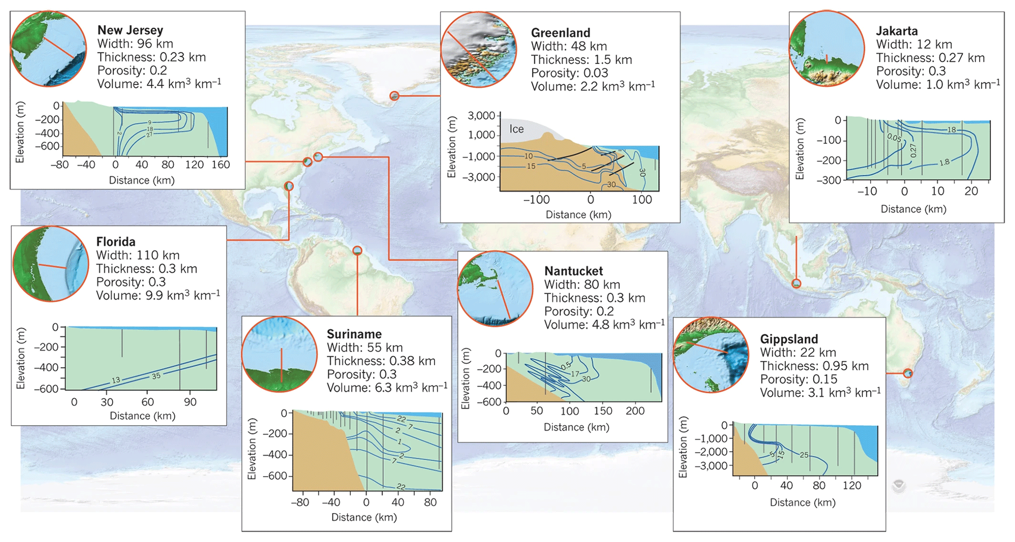
Figure 1Offshore freshwater cross sections around the world from Post et al. (2013). Blue contour lines indicate total dissolved solid (TDS) concentrations in parts per thousand (ppt), horizontal and vertical axes of cross sections are distance (km) and elevation (m) relative to mean sea level, and vertical grey lines indicate well locations where salinity is inferred from water samples and borehole logs.
The northeast coast of the US is perhaps the best-understood example of an offshore freshened water system with multiple studies trying to determine the origin and volume of offshore freshened water (e.g. Meisler et al., 1984; Person et al., 2003; Lofi et al., 2013). Drilling campaigns beginning in the 1970s documented that the Atlantic continental shelf hosts vast quantities of OFG in sub-seafloor depths > 100 m within marine clastic deposits (Hathaway et al., 1979). Cohen et al. (2010) estimate that there are about 1300 km3 of sequestered freshwater along the Atlantic continental margin between New Jersey and Maine; for perspective, the City of New York uses 1.5 km3 of freshwater per year. However, little is known about the origin of this freshened water or the timing of fluid emplacement. Thus, the primary objectives of the proposed research are to understand the spatial distribution of OFG, emplacement mechanisms of OFG, porewater geochemistry, microbe diversity and activity, and anomalous pressure distribution. This project will characterise the OFG extent and the transition to seawater which may be linked to submarine groundwater discharge on the shelf-slope break (Skarke et al., 2014, 2018) and to anomalous freshwater onshore (Marksamer et al., 2007). Globally, OFG occurs at many other locations below continental shelves (Fig. 1) (Post et al., 2013), and these aquifers are potential water reserves for densely populated near-shore regions. Understanding the processes driving emplacement of the freshened water lenses offshore New England will also lead to a better fundamental understanding of this worldwide hydrogeological phenomenon and its impact on biogeochemical cycling. This is essential for protection and sustainable management of these valuable resources in the near future and for better understanding biogeochemical cycling in shelf environments.
Motivation and need for ocean drilling
Prior drilling campaigns and paleohydrogeologic modelling studies provide evidence of freshened water extending far offshore along the North America Atlantic margin (e.g. Meisler et al., 1984). This freshened water may provide a buffer to increased demand, especially during periods of intense drought. There is growing evidence that passive margin sediments host large volumes of paleo-freshwater, and it is hypothesised that these waters were emplaced during the past 2 million years as a result of Pleistocene glaciations (Edmunds, 2001; Person et al., 2003, 2007, 2012; Lemieux et al., 2008; Jiráková et al., 2011; McIntosh et al., 2012; Neuzil, 2012; Zhang et al., 2018). Continental sedimentary basins and passive margins along the US Atlantic margin have been influenced by the Laurentide ice sheet, and aquifer–ice sheet coupling may explain the emplacement of fresh groundwater to depths up to 1000 m (McIntosh and Walter, 2005; Bense and Person, 2008; McIntosh et al., 2011). Evidence of glacially emplaced freshwater in basins comes from many sources, including 14C and noble gas ages (Klump et al., 2008; Morrissey et al., 2010; Darling, 2011; Schlegel et al., 2011) and oxygen isotope data (Rozanski, 1985; Vaikmäe et al., 2001; Darling, 2004; Négrel and Petelet-Giraud, 2011; McIntosh et al., 2012; van Geldern et al., 2014). These observations motivated numerous modelling studies that evaluated how sub-glacial meltwater may create non-equilibrium conditions and may drive freshwater deep into sedimentary basins (Person et al., 2007, 2012; Post et al., 2013; Siegel et al., 2014). IODP drilling offshore New Jersey (IODP Expedition 313; Mountain et al., 2009) has not only revealed non-equilibrium salinity conditions, but also shown significant impact of modern meteoric recharge (van Geldern et al., 2013).
Multiple mechanisms have been proposed to explain the emplacement of freshwater within continental shelf sediments during glacial periods. Early studies focused on the shore-normal hydraulic gradient associated with primary topography of the continental shelf as the prime driving force for freshwater recharge during sea-level lowstands (Meisler et al., 1984) (Fig. 2). Subsequently, Groen et al. (2000) argued that local flow systems associated with secondary topography of the subaerially exposed and incised shelf are essential to emplace meteoric water far out onto the continental shelf (Fig. 2). Person et al. (2003) then emphasised the role of sub-ice-sheet recharge (Fig. 2), whereas Mulligan and Uchupi (2003) and Person et al. (2012) suggested recharge from pro-glacial lakes (Fig. 2). The mechanism proposed by Groen et al. (2000) would be particularly viable if confining units are discontinuous, which is a situation indicated by IODP Expedition 313 drilling off New Jersey (Mountain et al., 2009). A problem that some of the above mechanisms face is that freshwater incursion far offshore is indicative of a permeable environment, whereas observed (Nantucket, well 6001) and interpreted (offshore New Jersey) excess fluid pressures suggest a low-permeability environment (Dugan and Flemings, 2000; Marksamer et al., 2007; Lofi et al., 2013).
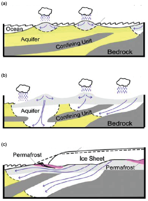
Figure 2Conceptual models of freshwater emplacement. Freshwater-saturated sediments are light grey and white; saltwater-saturated sediments are yellow. The freshwater–saltwater interface is marked with a dashed black line. (a) Equilibrium freshwater lens under present-day meteoric recharge produces a small lens of freshwater under islands (Glover, 1959). (b) Meteoric recharge to exposed aquifers and increased gradients during sea-level lowstand drive the freshwater–saltwater interface deeper and farther offshore (e.g. Kooi and Groen, 2001; Meisler et al., 1984). (c) Sub-ice-sheet recharge during a glacial period; high pressure from glacial advances drives freshwater deeper and pushes the freshwater–saltwater interface farther offshore (e.g. Person et al., 2003; Marksamer et al., 2007; Siegel et al., 2014).
To better understand the dynamics of these onshore–offshore hydrologic systems, a dedicated hydrogeological expedition is required. We propose a transect drilling approach to focus on the interactions between glacial dynamics, sea-level variations, and groundwater flow along the US Atlantic continental shelf extending south from Massachusetts, US (Figs. 3 and 4). This shelf experienced a number of glaciations in the late Pleistocene in combination with sea-level change throughout the Pleistocene (Oldale and O'Hara, 1984; Uchupi et al., 2001; Siegel et al., 2012). Glacial loading, sea-level fluctuations, and meteoric recharge processes have all been suggested as driving mechanisms that emplaced freshened water nearly 100 km offshore New Jersey down to depths of several hundred metres below the seafloor (m b.s.f.) (Hathaway et al., 1979; Kohout et al., 1988; Cohen et al., 2010; Lofi et al., 2013; Post et al., 2013; van Geldern et al., 2013). Dedicated drilling, coring, and analyses focused on the onshore–offshore hydrogeological system are required to fully understand emplacement processes and dynamics.
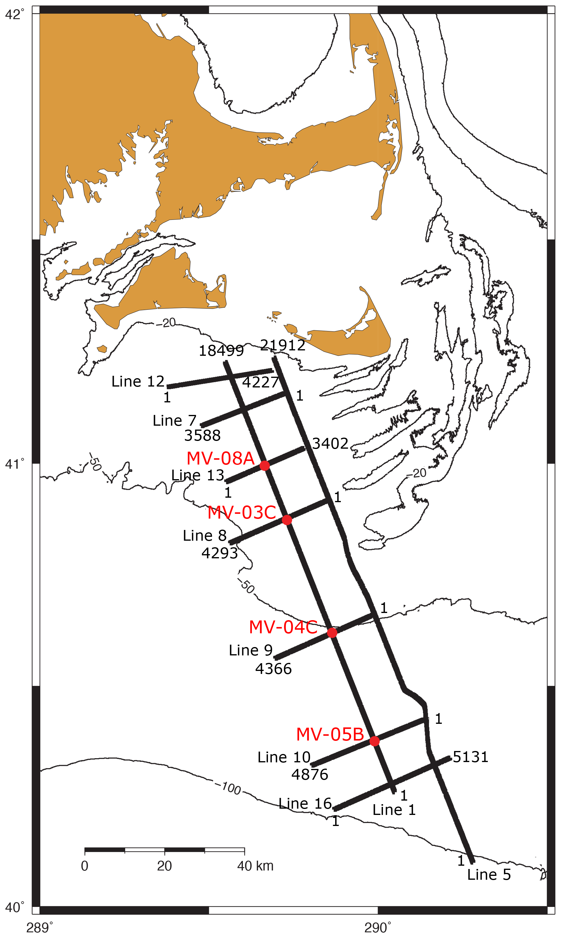
Figure 3Basemap of IODP drilling proposal 637 study region including proposed site (primary sites – solid red circles and red numbers; high-resolution multi-channel seismic (MCS) data (black lines), and common depth points (CDPs) (numbers at endpoints of MCS lines). Cross section A–A' (line 1) is shown in Fig. 4.
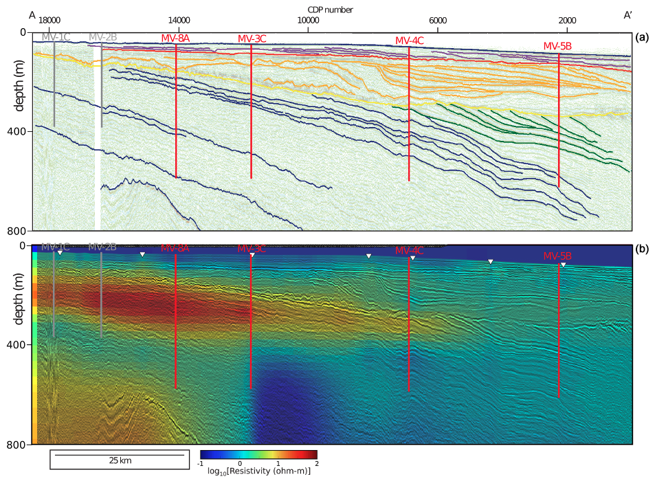
Figure 4(a) Depth-converted and interpreted seismic line A–A' (located in Fig. 3) showing location and proposed depths of primary sites MV-8A, MV-3C, MV-4C, and MV-5B (red lines, red numbers). Also shown are locations and proposed depths for alternate sites MV-1C and MV- 2B (grey lines, grey numbers). Details on seismic processing and interpretation are provided in Siegel et al. (2012). (b) Resistivity profile based on joint inversion of controlled-source electromagnetic and magnetotelluric data overlain on the depth-converted seismic line A–A' (located in Fig. 1) (Gustafson et al., 2019). Resistive zones are interpreted to be freshened water zones.
We argue that targeted drilling and coring including hydrogeochemical, microbiological, isotopic, and noble gas analysis and measurement of hydraulic properties and fluid pressures will yield a process-based understanding of the origin and volumes of offshore freshened water, how these fluids influence local and global biogeochemical cycles, and how they record climate cycles.
We propose a three-site, shallow-water drilling campaign on the Atlantic continental shelf off Martha's Vineyard, Massachusetts, US, to test our hypotheses and to map offshore freshened water. Our transect takes advantage of boreholes on Martha's Vineyard (ENW-05) and Nantucket (6001), builds on previous Atlantic Margin Coring (AMCOR) and IODP analyses, and is motivated by geophysical observations (stratigraphy, resistivity). Our transect will provide samples from the interpreted freshwater, freshwater–seawater transition, and seawater zones, allowing for a complete characterisation of the OFG system. Based on paleohydrologic reconstructions, we developed 2D and 3D models of the freshened water distribution and predicted the freshwater–seawater transition is < 30 km offshore. Electromagnetic data suggest the transition may extend up to 80 km offshore. Drilling will directly test these geophysical interpretations and provide additional constraints for hydrogeological models.
Our drilling campaign will require one mission-specific platform (MSP). We propose a programme similar to IODP Expedition 313 (Mountain et al., 2009) to increase recovery in unconsolidated sand units and a casing and/or screening programme to facilitate collection of pristine pore fluid samples for geochemical and microbiological analyses. Post-expedition numerical models will include the simulation of groundwater residence time and noble gas transport for comparison with field measurements. This highly interdisciplinary work will be one of the first focused hydrogeological–biogeochemical–microbiological studies of continental shelf systems.
3.1 Primary objectives and assessment
Objective 1. What is the distribution of freshened water, fluid pressures, and temperatures across the Atlantic continental shelf in New England?
We will directly sample water chemistry, pressures, and temperatures across the freshwater zone, the freshwater–saltwater transition, and the seawater zone and characterise how they relate to the glacial loading history.
Objective 2. How old is the groundwater, and when was it emplaced?
The deepest offshore freshwater is possibly Pleistocene in age and linked to glaciations. This will be tested with groundwater age analysis.
Objective 3. Was freshwater recharged by the basal melting of large ice sheets, infiltration from large pro-glacial lakes, direct recharge from precipitation, or combination of these processes? If the latter is true, what is their relative importance, and can their distribution and the age patterns be unravelled through hydrogeological process models?
Isotopic and age data and hydrologic parameter information that we will collect are required to fully constrain OFG system dynamics over time for the offshore component of this onshore–offshore freshwater system that may extend 80 km offshore.
Objective 4. What are the current concentrations and production/consumption rates of methane, nutrients, and rare Earth elements in shelf sediments? What controls them?
Nutrients and methane have been studied in the mid-continent and in near-shore environments. Our proposal targets offer a better understanding of an active shelf environment.
Objective 5. What are the rates of decomposition of sedimentary organic matter and which redox processes/microbial communities are involved? What sources of carbon do the shelf microbes utilise? Which factors determine the spatial distribution and activity of microbial communities in the shelf?
Dedicated organic matter sampling and microbiological analyses along our proposed transect are required to address these questions and will provide a first step to establishing how they change in the offshore environment.
3.2 Secondary objectives and assessment
Objective 6. Do fluid pressures reflect the current fluid density distribution and modern sea level, or are overpressuring mechanisms (e.g. rapid sediment loading) involved?
Onshore well data suggest non-equilibrium fluid pressure. Documenting the vertical and horizontal pressure distribution on the shelf and linking it with the process will test models for the origin of fluid overpressures as well as the timing of overpressure generation.
Objective 7. What are the magnitudes of long-term fluxes of methane and nutrients from the shelf due to periodic flushing during the Pleistocene?
We have developed process-based models for fluxes from the onshore to the offshore environment and drilling will provide model inputs (e.g. hydrological parameters) and test data for models (e.g. modern conditions that can be tested against forward models under different sea-level and glacial scenarios).
Objective 8. Does the emplacement of ice sheet meltwaters in confined aquifers create a unique environment for methane?
Vertical and horizontal profiling of waters emplaced at different times and under different hydrological conditions will provide new information to address this question.
Objective 9. What is the sea-level history along this glaciated margin?
Integrating sediment age and lithology data with the sequence stratigraphy will contribute to addressing this question.
Assessing objectives 1–3, 6, and 9 will provide new insights into shelf hydrogeology that will contribute to Strategic Objective (SO) 3 of the 2050 Scientific Framework (Koppers and Coggon, 2020) – Earth's climate system (ice sheets and sea-level rise), SO 4 – feedbacks in the Earth system (ice sheet grounding and stability), SO 6 – global cycles of energy and matter (matter cycling – water, freshwater aquifers), and Enabling Element (EE) 2 – land to sea (fluid flow across the coastlines). Assessing objectives 4 and 5 will provide new insights into shelf hydrogeology that will contribute to SO 1 – habitability and life on Earth (microbial influence on biogeochemical cycles), SO 6 – global cycles of energy and matter (matter cycling: water, freshwater aquifers, matter cycling: carbon), Flagship Initiative (FI) 4 – diagnosing ocean health (nutrient availability in the ocean), and FI 5 – exploring life and its origin (defining the rules of microbial life). As a project with direct societal impact, it will also be an asset for EE 1 – broader impacts and outreach.
3.3 Previous drilling
No previous drilling has been done in this region. The Atlantic Margin Coring Project (Hathaway et al., 1979) had sites located more than 100 km from Expedition 501 sites.
3.4 Proposed drilling
A significant component to IODP drilling proposal 637 is drilling and sampling the freshened water endmember, the seawater endmember, and the transition between the endmembers. The proposed drilling strategy is to drill MV-08A first to 550 m b.s.f. (below sea floor) (Fig. 4). This will sample the freshened water endmember which is predicted to be bounded on top and bottom by seawater. The second site to be drilled will be MV-03C to 550 m b.s.f. (Fig. 4). This is likely the freshwater–seawater transition based on electromagnetic and magnetotelluric data. The third site to be drilled will be MV-04C to 550 m b.s.f. (Fig. 4) to sample the seawater endmember as predicted by numerical models and electromagnetic and magnetotelluric data. Site MV-04C, however, could have a small component of freshened water.
4.1 Site locations
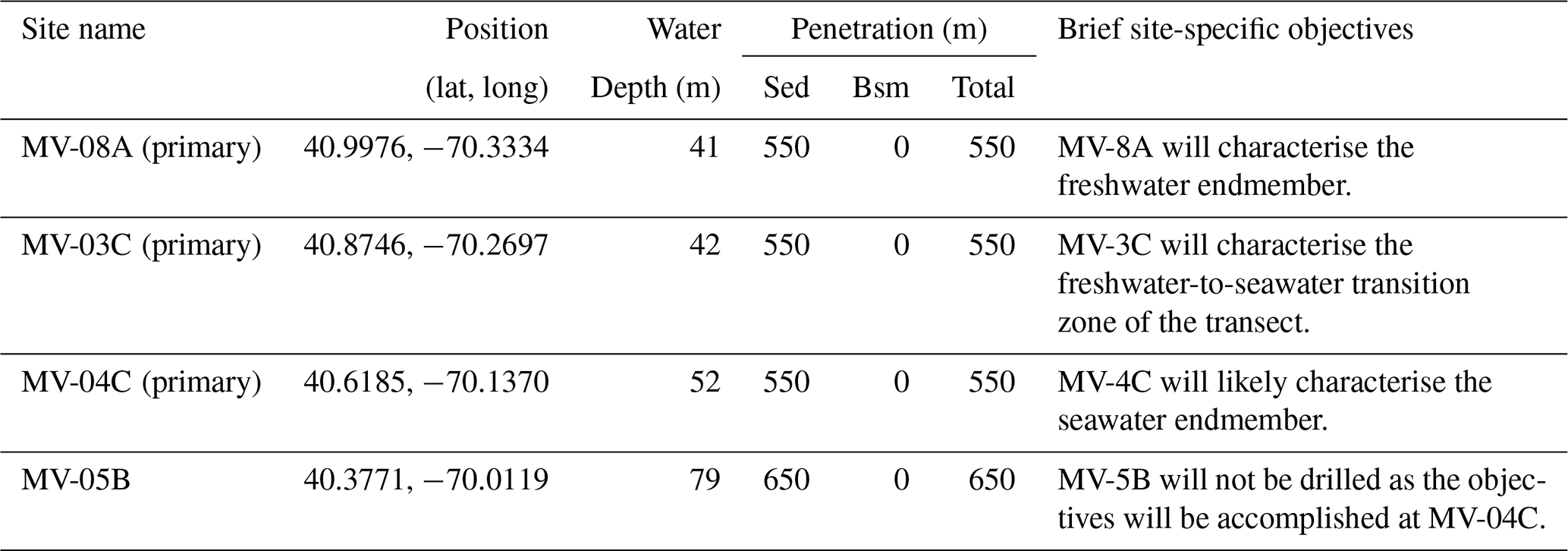
There are three primary sites located in water depths ranging from ca. 40–50 m and with total penetration depths ≤550 m b.s.f. (Table 1).
Sediments are expected to be predominantly sand, silt, and clay based on seismic interpretation and stratigraphic correlation with observations from IODP Expedition 313 (Mountain et al., 2009). Sites have been selected to target resistivity anomalies interpreted to reflected freshened groundwater (Gustafson et al., 2019), drilling depth constraints, and drilling time. To address the scientific objectives, the sites are specifically targeting
-
the freshened water endmember location, expected to be bounded above and below by seawater;
-
the freshwater–seawater transition that is also expected to be bounded above and below by seawater;
-
the seawater endmember, which may have a small contribution of freshened water.
MV-08A proposed drilling to 550 m b.s.f. to capture the freshened water endmember, to assess the age of the freshened water, and to characterise microbial diversity and activity in the freshened water and the overlying and underlying seawater. The lithology and hydrogeological properties will also be defined to better understand different emplacement mechanisms.
MV-03C proposed drilling to 550 m b.s.f. to capture the onset of the freshwater–seawater transition, to assess the amount of freshwater and seawater mixing, and to characterise microbial diversity and activity in a system that may be increasing in salinity in the modern environment. The lithology and hydrogeological properties will also be defined to better understand the dynamics of this transition.
MV-04C proposed drilling to 550 m b.s.f. to capture the likely seawater endmember that was likely freshened in the past, to understand when this location became dominated by saltwater, and to characterise the microbial system that has gone from freshened water to seawater. There is the potential that this site will have a minor amount of freshened water.
MV-05B will not be drilled during Expedition 501. The site was originally targeted as the definitive seawater endmember; however, the same objectives can be addressed with the project budget and time frame by drilling MV-04C.
Table 1Location of and information for proposed primary sites. Sed: sediment, Bsm: basement.
4.2 Site survey data
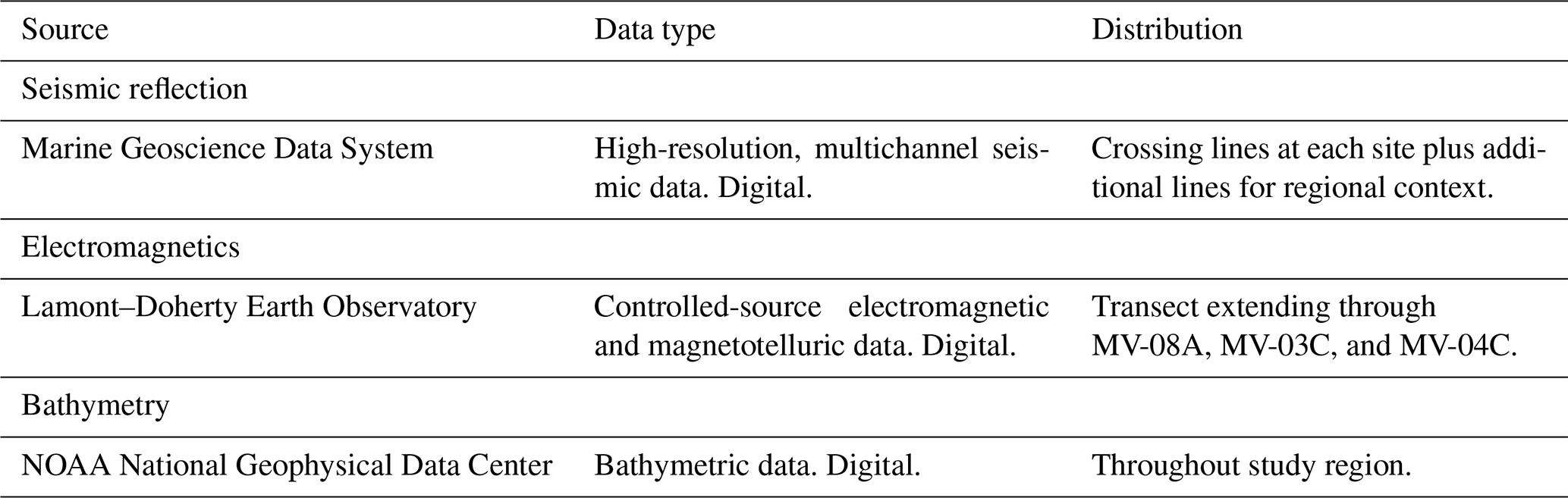
The Expedition 501 study area has been surveyed by a grid of high-resolution, multi-channel seismic (MCS) data (Table 2) (Siegel et al., 2012). Data were collected with a 45 in3/105 in3 generator–injector (GI) air gun and a digital streamer with 48 channels spaced at 12.5 m. Seismic processing included outside trace mute, bandpass filter, true amplitude recovery, f–k (frequency–wavenumber) filter, radon filter, deconvolution in the τ–p domain, normal-moveout (NMO) correction, post-stack deconvolution, Kirchhoff post-stack depth migration, and f–x (frequency–space) deconvolution. In water depths of 50–150 m, the water bottom multiple has been sufficiently suppressed by processing. Stacking velocity analysis was performed every 500 m, and interval velocities were calculated based on the stacking velocities. The data achieve a horizontal and vertical resolution of 7 m. All sites have crossing MCS lines.
Controlled-source electromagnetic (CSEM) data and magnetotelluric (MT) data were collected along a transect that connects all sites (Table 2) (Gustafson et al., 2019). In total, 10 MT stations were collected by deploying broadband seafloor electromagnetic (EM) receivers. Surface-towed CSEM data were collected with a 336.9 m long dipole antenna broadcasting an 88 A current (doubly symmetric square waveform; 0.25 Hz fundamental frequency). In addition, four broadband EM receivers were surface-towed (offsets 600, 870, 1120, and 1380 m). Then, 2D resistivity models were determined by inverting CSEM and MT data jointly and independently using MARE2DEM, a freely available goal-oriented adaptive finite-element inversion code.
Bathymetric data over the study sites come from the NOAA National Geophysical Data Center.
Table 2Geophysical site survey data used for the planning of Expedition 501. Seismic reflection data can be found at https://www.marine-geo.org/tools/search/entry.php?id=EN465 (last access: 3 June 2025).
5.1 Drilling platform
The proposal calls for a drilling platform that can operate in shallow water and deep penetration. The liftboat L/B Robert has been contracted to undertake the drilling and coring. Coring will be performed using soil boring equipment cantilevered from the main deck using a top-drive power swivel. The vessel has a cruise speed of 6 kn and total accommodation capacity of 148 people (including the crew). The equipment includes a top-drive surface coring rig with hands-free coring equipment, mud mixing, and pumping units, as well as other tools and accessories required to carry out the site investigation. Heave motion compensation will not be required as the secure positioning of the liftboat on the seabed will ensure the drill bit maintains a uniform pressure on the base of the borehole during drilling operations. An ample supply of drilling mud will be provided, and a spare string of drill pipe, sufficient spare parts, and other supplies required will be available. The drilling fluid used will be seawater and/or TP-012, a biodegradable polymer for use in brackish water.
5.2 Downhole-depth control
Prior to commencing drilling operations, water depth is measured and adjusted to local mean sea level (MSL). Water depth measurements will be performed using the drill string lowered onto the seabed. At this time, the “air gap” (i.e. the distance between the drill floor and the water level) shall be measured to assist with the accurate determination of the drill being depth below seabed.
5.3 Coring methodology
Wireline coring will be done using QD TECH 450 series tools. QD TECH offers a wide range of inner barrels to handle varied lithology. The 450 hydraulic piston core (HPC) inner assembly is for collecting soft sediments up to moderately stiff clay. The 450 extended nose punch core (EXN) is an assembly for collecting core samples in sediment using direct push force. The 450 “alien” flush – extended lithified/rock coring (ALN) is an inner tube assembly for collecting core samples in harder formations that cannot be sampled using either of the two push style samplers. The 450 non-coring inner assembly (NCA) inner tube assembly places a full-face drill bit within the main outer bit. Coring will commence using the piston core (HPC) assembly and will continue to be used until quality or penetration rate drops. At this point, the nose punch core (EXN) assembly will be used, ideally until full depth. The ALN tool will be used if the limitations of the other tools are reached. The main suite uses a nominal diameter of 3.0′′ (76.2 mm) and polycarbonate plastic liners.
Typically, every core run will be 3 m in length, however, shorter core runs can be made if the formation is blocking the bit or if it is too friable to withstand a 3 m run.
Backup tools providing cores in 83 and 61 mm diameter will also be made available. The BLY PQ3 core barrel produces a 3-1/4′′ (83 mm) core, and the BLY HQ3 core barrel produces a 2-3/8′′ (61 mm) core.
All boreholes will be drilled using a 6-5/8′′ buttress casing through the water column. The casing will be washed into the seabed to create a “riser” with a natural seal allowing the system to recirculate all drill fluids.
Uncased sections of boreholes are expected to naturally collapse shortly after operations are concluded. Thus, casing will be removed from at least the top-hole section, with natural collapse being the preferred abandonment method.
5.4 Downhole logging
In all MSP expeditions, the downhole logging programme, coordinated by the European Petrophysics Consortium (EPC), is an integral part of the offshore operations and is designed to help meet the expedition-specific scientific objectives and maximise scientific output.
The various coring strategies and resulting logging conditions (e.g. water depth, pipe and borehole diameter) on MSPs require an appropriate set of logging tools. The type of logging tools used, including super-slimline tools, memory-mode tools and standard oilfield tools, varies from expedition to expedition. For Expedition 501, logging services are contracted to the University of Montpellier (France). Their suite of slimline tools can be used alone or stacked in a tool string, offering the possibility of collecting multiple measurements in a single tool string run. During the expedition, the Petrophysics Staff Scientists will liaise with the Co-Chief Scientists, Expedition Project Managers, the operational team, the Science Team, and the logging engineers to ensure that the best decisions are made to address the scientific objectives, taking into consideration both time constraints and borehole conditions.
The tool suite available for Expedition 501 includes a spectral and total gamma ray, sonic (P-wave velocity), formation conductivity and magnetic susceptibility, hydrogeological measurements (borehole fluid temperature and conductivity), caliper, and flowmeter. The use of the entire tool suite is dependent on borehole conditions and stability. A novelty explored for this expedition is the use through polyvinyl chloride (PVC) casing of nuclear magnetic resonance (NMR) in order to characterise the porosity and permeability (with calibration via post-expedition experiments) of the formation. The use of the NMR tool is dependent on the overall operational strategy.
For Expedition 501, two holes will be drilled at each site, one for coring and logging and the other one to perform pumping tests. The plan is to acquire as much downhole logging data as borehole conditions safely allow, for the selected tools, in each cored hole. To address the scientific objectives, and based on the available tools, the ideal logging plan will include a gamma ray, sonic, magnetic susceptibility, formation conductivity, borehole fluid properties, and porosity. First, the spectral gamma ray log will be acquired through the drill pipe as soon as coring operations are complete. This step ensures the collection of a continuous dataset that can be used to (1) correlate downhole values to multi-sensor core logger (MSCL) gamma ray values and (2) correlate different holes. Following that, depending on the operational strategy and borehole conditions, the other tools will be deployed. Once operations at the first hole are complete, a second hole will be drilled without coring to perform pumping tests. If needed, the spectral gamma ray tool will be deployed through the drill pipe to confirm the main lithology and that the target intervals have been reached.
The Petrophysics Staff Scientist will be responsible for data processing, quality assurance/quality control (QA/QC) of data, and ongoing scientific support for data interpretation and research. The final set of downhole data (following the full QA/QC process) will be made available to the Science Team at the commencement of the onshore operations (ONO).
5.5 Groundwater extraction methodology
Intervals of interest will be screened using Standard Wireline Packer System (SWiPS). The SWiPS system includes hydraulically inflated packers and can be configured as a single or straddle packer system.
To ensure that the borehole conditions are most appropriate for pristine water sampling, each site will have a second borehole drilled for water extraction. If the conditions of the first borehole are favourable, an attempt may be made to extract water from the first (cored) borehole.
The initial water flow could be artesian. In the case of insufficient artesian flow, airlifting or swabbing techniques will be used. This is to preserve electric submersible pumps, which are unlikely to deal well with sand. Once the borehole is clean from sand, if needed, an electrical submersible pump (ESP) will be lowered to as deep as 100 m below rig floor. The pumping will continue until the water is deemed pristine and all the samples have been collected. A miniRUEDI (portable mass spectrometer) and a water quality monitoring sensor will be used to identify when the water has reached pristine levels.
The wellhead attached to the ESP is equipped with “vampire ports” for collecting smaller fluid samples and measuring fluid pressures during pump tests.
As with cored boreholes, natural collapse will be the preferred abandonment method.
5.6 Long-term condition monitoring
A seafloor borehole observatory may be installed at up to two sites. The simple cabled instrument for measuring parameters in situ (SCIMPI) will be installed at the conclusion of operations before abandoning the borehole.
The tool, which is the length of the borehole, is deployed through the drill string and left inside the borehole. Ballasts and flotation devices keep the tool in place, while a command module extends a couple of metres above borehole. The system measures pressure, temperature, and resistivity at various pre-defined borehole depths.
5.7 Site priorities and contingency considerations
In this section, we provide an overview of operations including strategy and prioritisation for coring, logging, pump tests, and long-term monitoring, The planned order of operations is MV-08A, then MV-03C, and finally MV-04C. MV-08A will be the first site as it is interpreted to contain significant amounts of freshened water, which is the overarching target of the expedition. Operations in Hole A will include coring and logging to a maximum depth of 550 m b.s.f. Operations may be concluded at a shallower depth of porewater data show freshened water underlain by a consistent return to seawater salinity at depths shallower than 550 m b.s.f. Upon completion of Hole A, Hole B will be drilled for targeted pump tests and water sampling based on interstitial water chemistry data and borehole logging data. Pump tests will target zones that are sand-rich and contain freshened water. MV-03C will then be drilled to continue to assess the freshened water system as it transitions to seawater. The same Hole A and Hole B strategies used at MV-08A will be employed at MV-03C. MV-04C will be drilled last to sample the seawater endmember. MV-04C will only have one hole focussed on coring and logging. MV-04C could be shallowed significantly if no contribution of freshened water is determined by 400 m b.s.f. In the event that borehole conditions are problematic, (1) logging will prioritise gamma radiation and formation conductivity and (2) the number of pump tests will be scaled back to accommodate one pump test at MV-08A and one at MV-03C. The installation of long-term borehole monitoring systems (SCIMPI) will be closely evaluated in the context of operational time and success of pump tests.
5.8 Core on deck
As cores are recovered to deck, they will undergo initial labelling and sampling on a core bench prior to delivery to the curation container. The operation will proceed using a changeover of inner core barrels to ensure continuity of the coring operation in as timely a fashion as possible. The deck operators will deploy an empty core barrel immediately after the previous one has been retrieved and then address the core removal and subsequent readying of that core barrel for re-use. As the cores will be collected in a plastic liner, the usual IODP procedures for curation, initial sampling, and analyses will follow the IODP3 Standard Measurements policy. After curation (and temperature equilibration), unsplit core sections and core catcher materials will be passed to the Science Team members for onboard description, physical properties measurements, analysis, and sampling as described in the “Science operations” section below.
A sampling and measurement plan (SMP) for Expedition 501 has been prepared by ESO and the Co-Chief Scientists to meet the scientific objectives of IODP proposal 637-Full2 and addenda 637-Add3, 637-Add7, and 637-Add82.
6.1 Offshore science activities
It is the nature of MSP expeditions that there is limited laboratory space and accommodation on the platforms compared to the larger research drilling vessels JOIDES Resolution and Chikyu, and as such, there is no splitting of the cores at sea with only selected scientific analysis carried out on board by a sub-set of the Science Team. Science activities on the platform are confined to those essential for decision-making at sea, core curation, measurement of ephemeral properties, securing of samples for pore water chemistry, and downhole logging. Cores will typically be cut into 1.5 m lengths for curation. Most of the scientific analyses are carried out during the onshore operations (ONO) in Bremen (Germany) when the cores are split.
The following is a summary of the offshore scientific activities (please refer to the Expedition 501 sampling and measurement plan and the online tutorial, to be made available following conclusion of Sample Allocation Committee, SAC, review):
-
basic curation, photography, and labelling of the core;
-
measuring all cores (> 10 cm) on the multi-sensor core logger (MSCL; gamma density, P-wave velocity, electrical resistivity, magnetic susceptibility, and natural gamma radiation);
-
core catcher (CC) sampling, if available, for initial sedimentological, micropaleontological, petrophysical and/or structural characterisation, including taking a CC image;
-
taking and storage of groundwater from various depths in drilled boreholes under the assumption that the contractor and the Science Team are responsible for the equipment and sampling;
-
taking and proper storage of groundwater samples, again on the assumption that the contractor and the Science Team are responsible for the equipment and sampling, gas analyses, and acquisition and splitting of groundwater samples;
-
groundwater geochemistry analysis and any other ephemeral properties agreed in the sampling and measurement plan;
-
taking and proper storage of samples for gas analyses, and acquisition and splitting of porewater samples;
-
porewater geochemistry analysis and any other ephemeral properties agreed in the sampling and measurement plan;
-
core storage;
-
downhole logging;
-
preliminary core–log–seismic integration using available downhole logging data and/or core physical properties data;
-
associated data management of all activities (see below).
In order to deliver the scientific requirements on the platform with a sub-set of the Expedition Science Team, a staffing plan has been devised. The plan requires flexibility of approach from all participants, with priority given to safety, core recovery, curation, and procedures for the measurement of ephemeral properties.
Report preparation will take place on board as required; the reports to be compiled include the following:
-
Daily and weekly operational reports will be compiled by ESO and provided to the management and panels of ECORD and IODP3, Science Team members, and any other relevant parties. Scientific reports are provided by the Co-Chief Scientists. Summarised daily reports will be publicly available on the ESO website for any interested parties.
-
Completion of the offshore sections of the expedition reports (primarily the Methods chapter, but also recording of initial results from offshore observations, measurements, and analyses) will be undertaken by offshore Science Team members and ESO staff.
-
Press releases in line with ECORD outreach policy and Information for posting on the ESO expedition website will be managed by the Communications Task Force.
6.2 Onshore science activities
The onshore operations (ONO) will be held at the Bremen Core Repository (BCR) at the MARUM, Center for Marine Environmental Sciences, University of Bremen, Germany. The scientific work will follow the sampling and measurement plan to be developed in conjunction with the Co-Chief Scientists. The majority of the scientific reporting for the expedition is also undertaken during the onshore operations by Expedition Science Team members.
Details of the facilities that will be available for the onshore operations at the IODP Bremen Core Repository and MARUM laboratories can be found in the Expedition 501 sampling and measurement plan (SMP) (https://www.marum.de/en/Exp.-501-sampling-and-measurement-plan.html, last access: 3 June 2025), which will be made available following conclusion of the Sample Allocation Committee review. The measurement plan will take account of MSP specifications for QA/QC procedures. Additional facilities can be made available through continuing close co-operation with additional laboratories at the MARUM, Center for Marine Environmental Sciences, and the Department of Geosciences at the University of Bremen, all of which are situated nearby on campus.
The following briefly summarises the ONO scientific activities:
-
Prior to the onshore operations, thermal conductivity measurements will be taken on all cores (as appropriate) using a needle probe. Additional standard MSP physical properties measurements may be undertaken on whole cores at this time in the event offshore datasets are incomplete. This may be owing to time (natural gamma radiation) or permitting issues (gamma density). These measurements will be undertaken by ESO personnel.
-
Regarding core splitting, an archive half will be set aside following procedures established by DSDP/ODP/IODP (DSDP: Deep Sea Drilling Project, ODP: Ocean Drilling Program).
-
Regarding core description, ESO will provide a data-entry system that is standard to IODP3 or scientific ocean drilling programmes. For data entry, ESO will employ the expedition mDIS (mobile Drilling Information System) that is entirely compatible with others being used in the scientific ocean drilling programmes. Please see the “Data management” section below.
-
High-resolution digital imaging will be performed using a digital line-scan camera system.
-
Colour reflectance spectrophotometry will be performed using a spectrophotometer.
-
P-wave velocities will be measured on discrete samples using an MSCL discrete P-wave system (MSCL-DPW).
-
Moisture and density (MAD) will be measured on discrete samples using a pycnometer.
-
Core sampling for expedition (shipboard) samples (to produce MSP standard measurements data for the expedition report, e.g. petrophysical properties P-wave, moisture, and density analyses).
-
Smear slide preparation will be undertaken by sedimentologists and/or micropaleontologists at regular intervals (as required).
-
Thin section preparation will be performed (as requested).
-
Biostratigraphy will be done.
-
Attention will be paid to inorganic geochemistry (whole-rock and pore fluid chemistry) and organic geochemistry.
-
Bulk mineralogy will be performed by X-ray diffraction (XRD) analysis.
-
Paleomagnetic measurements will be carried out (as requested).
-
Core sampling for personal post-expedition research will be performed; a detailed sampling plan will be devised after the scientists have submitted their revised sample requests following completion of the offshore operations (please see the “Research planning: sampling and data sharing strategy” section below). This will likely include whole round samples for experimental post-cruise analysis, taken prior to splitting of the cores. Sample allocation will be determined by the Sample Allocation Committee (SAC; see below for further details).
In view of the existing geographical distribution of all scientific ocean drilling programmes (DSDP/ODP/IODP) cores, it is understood that the Bremen Core Repository (BCR) will be the long-term location for the Expedition 501 cores.
Report preparation will take place during the ONO as required by ECORD. The reports to be compiled include
-
weekly progress reports to ECORD and relevant parties (scientific reports are provided by the Co-Chief Scientists),
-
Expedition Summary compiled by the Expedition Science Team (submission to Copernicus Publications at the end of the onshore operations),
-
Site Reports compiled by the Expedition Science Team (submission to Copernicus Publications services as soon as practically possible after the onshore operations).
For more information, please refer to the SMP link above and also the online tutorial (to be made available following the conclusion of the review by the SAC).
6.3 Staffing
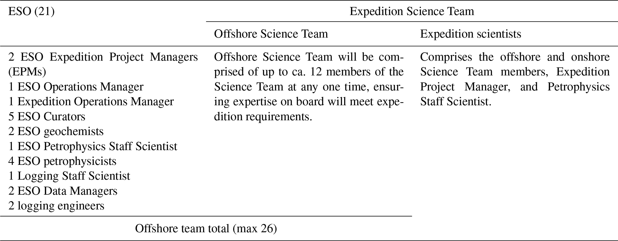
Scientific staffing is determined on the basis of task requirements and nominations from the IODP3 programme member offices (https://www.iodp.org/about-iodp/program-member-offices, last access: 3 June 2025). ESO staffing is based on the need to carry out the drilling and scientific operations safely and efficiently (Table 3).
Table 3Summary of the Expedition Science Team and Operator (ESO) personnel for Expedition 501.
6.4 Data management
A data management plan for the expedition will be developed once the data requirements and operational logistics are finalised. The outline plan is as follows:
-
The primary data capture and management system will be the expedition mobile Drilling Information System (mDIS; https://www.marum.de/en/Curatorial-Database-and-Sample-Management-System.html, last access: 3 June 2025). mDIS is a database management application originally developed from collaboration with the International Continental Drilling Program operations group (GeoForschungsZentrum, Potsdam) with adaptions to ESO for capturing and curating metadata on geological cores and samples, drilling progress, and lithology on MSP expeditions.
-
The expedition mDIS includes tools for data input, visualisation, report generation, and data export.
-
The database can be accessed directly by other interpretation or decision-making applications if required.
-
A file server will be used for the storage of data not captured in the database (for example, documents and image files) and the inputs/outputs of any data processing, interpretation, and visualisation applications used during the expedition.
-
On completion of the offshore operations of the expedition, the expedition mDIS and the file system will be transferred to the BCR to continue data capture during the onshore operations.
-
Between the end of the offshore operations and the start of the onshore operations, the expedition scientists will have access to the data via a password-protected website.
-
On completion of the onshore operations, expedition scientists will continue to have access to all data through a password-protected website throughout the moratorium period.
-
During the moratorium, all metadata and data, apart from downhole logging data, will be transferred to the PANGAEA data repository for long-term archiving.
-
The Petrophysics Staff Scientist will manage the downhole logging data (including formation temperature measurements), MSCL data, and other physical property data.
-
Downhole logging data will be stored separately for processing and compositing and will be made available to the Science Team via the log database hosted by the Lamont–Doherty Earth Observatory. These data will be archived at the Lamont–Doherty Earth Observatory.
-
After the moratorium, cores and samples will be archived at the BCR.
-
After the moratorium, all the expedition data will be made accessible to the public.
6.5 Outreach
The IODP3 Communications Task Force (CTF) will be working to promote the expedition and the science generated by this investigation into shelf hydrogeology. As guidance, the CTF have produced a communications plan that will be distributed to the Science Team prior to sailing. The main objectives are
-
to interact positively with the media, non-governmental organisations (NGOs), governments, and the general public to demonstrate the benefits of the IODP3–NSF New England Shelf Hydrogeology scientific expedition (and IODP3 in general);
-
to maximise the expedition's publicity impact among scientists and the public;
-
to ensure that all outreach is conducted in a consistent way;
-
to promote scientific research with respect to the scientific goals;
-
to successfully continue the media relationships which were established during the previous seven ECORD mission-specific platform and other IODP expeditions.
To facilitate the above, there will be a number of outreach activities being conducted throughout the expedition.
Outreach activities before the start of the expedition are to
-
develop a communications plan in close cooperation with Co-Chief Scientists, ECORD/ESO staff, and especially the Expedition Project Managers;
-
produce and distribute an expedition flyer;
-
produce a media pack on the ESO website, including the expedition's web page and biographies of the Co-Chief Scientists and other members of the Science Team;
-
distribute a regional (New England) media release in parallel with the start-up media briefing;
-
organise ship visits for the media during mobilisation in New England, if possible;
-
prepare an outreach document for the Science Team, explaining their responsibilities;
-
produce a document with responses to frequently asked questions to distribute to the general public;
-
produce a guide to social media to distribute to the Science Team;
-
network with participants' university media offices, particularly the Co-Chief Scientists' host organisations;
-
produce an official expedition logo for use on all promotional materials.
Outreach activities during the offshore operations of the expedition are to
-
maintain daily/weekly expedition logbook on ESO website (coordinated by the ESO outreach manager).
-
publish media releases (in the case of special events/findings and, if appropriate, at the end of the expedition).
-
organise video coverage of the working processes on board the expedition vessel (B-roll footage) to be collected by ESO staff and Science Team members when time allows.
-
promote the expedition through national and international media and organise interviews with Co-Chief Scientists and other Science Team members as necessary/requested.
-
promote social media blogs compiled by Science Team and ESO members.
Outreach activities during the onshore operations are to
-
prepare background material to provide to the media;
-
hold a media day towards the end of the ONO;
-
publish an international media release (tentative results);
-
document activities with photos and video footage.
Outreach activities after the expedition are
-
promotion at international conferences (booths, talks), for example, at EGU and AGU/JpGU–AGU meetings;
-
general outreach to the media as scientific results of the expedition become available;
-
continued logging of any outreach activities undertaken by any of the Science Team members, including interviews, blogs, and abstracts submitted. ESO outreach team will depend on Science Team members to alert us to anything they do in addition monitoring international (mostly online) media.
All researchers requesting samples should refer to the Scientific Ocean Drilling Programmes' Sample, Data and Obligations Policy (https://iodp3.org/documents/sample-data-obligations-policy/, last access: 3 June 2025). This outlines the policy for distributing scientific ocean drilling programme samples and data to research scientists, curators, and educators. It also defines the obligations that sample and data recipients incur. The Sample Allocation Committee (SAC; composed of Co-Chief Scientists, Expedition Project Manager, and Scientific Ocean Drilling Programmes Curator for Europe (BCR and MSPs) or offshore curatorial representative) will work with the entire Science Team to formulate an expedition-specific sampling plan for shipboard (expedition: offshore and ONO) and post-cruise (personal post-expedition research) sampling.
Members of the Science Team are expected to carry out scientific research for the expedition and publish it. Before the expedition, all members of the Science Team are required to submit research plans and associated sample/data requests via the Sample, Data, and Research Request Manager (SDRM) system (https://web.iodp.tamu.edu/SDRM/#/, last access: 3 June 2025) before the deadline specified in their invitation letters. Based on sample requests submitted by this deadline, the SAC will prepare a tentative sampling plan, which can be revised on the ship and once cores are split as dictated by recovery and cruise objectives. All post-cruise research projects should provide scientific justification for desired sample size, numbers, and frequency. The sampling plan will be subject to modification depending upon the material recovered and collaborations that may evolve between scientists during the expedition. This planning process is necessary to coordinate the research to be conducted and to ensure that the scientific objectives are achieved. Modifications to the sampling plan and access to samples and data during the expedition and the 1-year post-expedition moratorium period require the approval of the SAC.
Offshore sampling will be restricted to that necessary for acquiring ephemeral data types which are critical to the overall objectives of the expedition and to preliminary lithological and biostratigraphic sampling to aid decision-making at sea and planning for the ONO.
The permanent archive halves are officially designated by the scientific Ocean Drilling Programmes Curator for BCR and MSPs. All sample frequencies and volumes must be justified on a scientific basis and will depend on core recovery, the full spectrum of other requests, and the expedition objectives. Some redundancy of measurement is unavoidable, but minimising the duplication of measurements among the shipboard party and identified shore-based collaborators will be a factor in evaluating sample requests.
If critical intervals are recovered, there may be considerable demand for samples from a limited amount of cored material. A sampling plan coordinated by the SAC will be required before critical intervals are sampled.
The SAC strongly encourages, and may require, collaboration and/or sharing among the shipboard and shore-based scientists so that the best use is made of the recovered core. Coordination of post-cruise analytical programmes is anticipated to ensure that the full range of geochemical, isotopic, and physical property studies are undertaken on a representative sample suite. The majority of sampling will take place at the onshore operations in Bremen, and the SAC encourages scientists are to start developing collaborations before and during the expedition.
After the moratorium, all data will be made available to the public via the PANGAEA data repository. Seismic reflection data can be found at https://www.marine-geo.org/tools/search/entry.php?id=EN465 (last access: 3 June 2025; Siegel et al., 2012). Bathymetric data can be found at https://ncei.noaa.gov/access (NOAA, 2025). Controlled-source electromagnetic and magnetotelluric data are not available as the data repository listed in the original publication (Gustafson et al., 2019) is no longer active.
BD developed the scientific approach. JE prepared the manuscript with contributions from BD and KJ.
The contact author has declared that none of the authors has any competing interests.
Publisher’s note: Copernicus Publications remains neutral with regard to jurisdictional claims made in the text, published maps, institutional affiliations, or any other geographical representation in this paper. While Copernicus Publications makes every effort to include appropriate place names, the final responsibility lies with the authors.
The authors acknowledge all reviewers of the original proposal who provided constructive feedback and the IODP Environmental Protection and Safety Panel who helped ensure safe operation conditions and guidance for environmentally responsible operations. Additionally, the authors thank the US National Science Foundation for assistance with permitting for the expedition.
This paper was edited by Myriam Kars and reviewed by two anonymous referees.
Barlow, P. M. and Reichard, E. G.: Saltwater intrusion in coastal regions of North America, Hydrogeol. J., 18, 247–260, https://doi.org/10.1007/s10040-009-0514-3, 2010.
Bense, V. F. and Person, M. A.: Transient hydrodynamics within intercratonic sedimentary basins during glacial cycles, J. Geophys. Res., 113, 2003–2012, https://doi.org/10.1029/2007JF000969, 2008.
Cohen, D., Person, M., Wang, P., Gable, C. W., Hutchinson, D., Marksamer, A., Dugan, B., Kooi, H., Groen, K., Lizarralde, D., Evans, R. L., Day-Lewis, F. D., and Lane Jr., J. W.: Origin and Extent of Fresh Paleowaters on the Atlantic Continental Shelf, USA, Groundwater, 48, 143- 158, https://doi.org/10.1111/j.1745-6584.2009.00627.x, 2010.
Darling, W. G.: Hydrological factors in the interpretation of stable isotopic proxy data present and past: a European perspective, Quaternary Sci. Rev., 23, 743–770, https://doi.org/10.1016/j.quascirev.2003.06.016, 2004.
Darling, W. G.: The isotope hydrology of quaternary climate change, J. Hum. Evol., 60, 417–427, https://doi.org/10.1016/j.jhevol.2010.05.006, 2011.
Dugan, B. and Flemings, P. B.: Overpressure and fluid flow in the New Jersey continental slope: Implications for slope failure and cold seeps, Science, 289, 288–291, https://doi.org/10.1126/science.289.5477.288, 2000.
Edmunds, W. M.: Palaeowaters in European coastal aquifers; the goals and main conclusions of the PALAEAUX Project, Geol. Soc. SP, 189, 1–16, https://doi.org/10.1144/GSL.SP.2001.189.01.02, 2001.
Glover, R. E.: The pattern of freshwater flow in a coastal aquifer, J. Geophys. Res., 64, 457–459, https://doi.org/10.1029/JZ064i004p00457, 1959.
Groen, J., Velstra, J., and Meesters, A.G.C.A.: Salinization processes in paleowaters in coastal sediments of Suriname: evidence from δ37Cl analysis and diffusion modelling, J. Hydrol., 234, 1–20, https://doi.org/10.1016/S0022-1694(00)00235-3, 2000.
Gustafson, C., Key, K., and Evans, R.L.: Aquifer systems extending far offshore on the U.S. Atlantic margin, Sci. Rep.-UK, 9, 8709, https://doi.org/10.1038/s41598-019-44611-7, 2019.
Hathaway, J. C., Poag, C. W., Valentine, P. C., Millerk, R. E., Schultz, D. M., Manheim, F. T., Kohout, F. A., Bothner, M. H., and Sangrey, D. A.: U.S. Geological Survey core drilling on the Atlantic Shelf, Science, 206, 515–527, https://doi.org/10.1126/science.206.4418.515, 1979.
Jiráková, H., Huneau, F., Celle-Jeanton, H., Hrkal, Z., and Le Coustumer, P.: Insights into palaeorecharge conditions for European deep aquifers, Hydrogeol. J., 19, 1545–1562, https://doi.org/10.1007/s10040-011-0765-7, 2011.
Klump, S., Grundl, T., Purtschert, R., and Kipfer, R.: Groundwater and climate dynamics derived from noble gas, 14C, and stable isotope data, Geology, 36, 395–398, https://doi.org/10.1130/G24604A.1, 2008.
Kohout, F. A., Meisler, H., Meyer, F. W., Johnston, R. H., Leve, G. W., and Wait, R. L.: Hydrogeology of the Atlantic continental margin, in: The Atlantic continental margin, U.S. edited by: Sheridan, R. E. and Grow, J. A., Geological Society of America, Boulder, USA, 463–480, https://doi.org/10.1130/DNAG-GNA-I2.463, 1988.
Konikow, L. F. and Kendy, E.: Groundwater depletion: A global problem, Hydrogeol. J., 13, 317–320, https://doi.org/10.1007/s10040-004-0411-8, 2005.
Kooi, H. and Groen, K.: Offshore continuation of coastal groundwater systems; predictions using sharp-interface approximations and variable-density flow modelling, J. Hydrol., 246, 19–35, https://doi.org/10.1016/S0022-1694(01)00354-7, 2001.
Koppers, A. A. P. and Coggon, R. (Eds): Exploring Earth by Scientific Ocean Drilling: 2050 Science Framework, 124 pp., https://doi.org/10.6075/J0W66J9H, 2020.
Lemieux, J.-M., Sudicky, E. A., Peltier, W. R., and Tarasov, L.: Dynamics of groundwater recharge and seepage over the Canadian landscape during the Wisconsinian glaciation, J. Geophys. Res., 113, 1–18, https://doi.org/10.1029/2007JF000838, 2008.
Lofi, J., Inwood, J., Proust, J. N., Monteverde, D. H., Loggia, D., Basile, C., Otsuka, H., Hayashi, T., Stadler, S., Mottl, M. J., and Fehr, A.: Fresh-water and salt-water distribution in passive margin sediments: Insights from Integrated Ocean Drilling Program Expedition 313 on the New Jersey Margin, Geosphere, 9, 1009–1024, https://doi.org/10.1130/GES00855.1, 2013.
Marksamer, A. J., Person, M., Day-Lewis, F. D., Lane, J. W., Cohen, D., Dugan, B., Kooi, H., and Willett, M.: Integrating geophysical, hydrochemical, and hydrologic data to understand the freshwater resources on Nantucket Island, Massachusetts, in: Data integration in subsurface hydrology, edited by: Hyndman, D. W., Day-Lewis, F. D., and Singha K., Geophysical Monograph Series, 171, 143–159, https://doi.org/10.1029/171GM12, 2007.
McIntosh, J. C., Garven, G., and Hanor, J. S.: Impacts of Pleistocene glaciation on large-scale groundwater flow and salinity in the Michigan Basin, Geofluids, 11, 18–33, https://doi.org/10.1111/j.1468-8123.2010.00303.x, 2011.
McIntosh, J. C., Schlegel, M. E., and Person, M.: Glacial impacts on hydrologic processes in sedimentary basins: evidence from natural tracer studies, Geofluids, 12, 7–21, https://doi.org/10.1111/j.1468-8123.2011.00344.x, 2012.
McIntosh, J. C. and Walter, L. M.: Volumetrically significant recharge of Pleistocene glacial meltwaters into epicratonic basins: Constraints imposed by solute mass balances, Chem. Geol., 222, 292–309, https://doi.org/10.1016/j.chemgeo.2005.07.010, 2005.
Michael, H. A. and Khan, M. R.: Impacts of physical and chemical aquifer heterogeneity on basin-scale solute transport: Vulnerability of deep groundwater to arsenic contamination in Bangladesh, Adv. Water Resour., 98, 147–158, https://doi.org/10.1016/j.advwatres.2016.10.010, 2016.
Meisler, H., Leahy, P. P., and Knobel, L.L.: Effects of eustatic sea-level change on saltwater- freshwater relations in the Northern Atlantic coastal plain, US Geological Survey, Water Supply Paper, 2255, https://doi.org/10.3133/wsp2255, 1984.
Morrissey, S. K., Clark, J. F., Bennett, M., Richardson, E., and Stute, M.: Groundwater reorganization in the Floridan aquifer following Holocene sea-level rise, Nat. Geosci., 3, 683–687, https://doi.org/10.1038/ngeo956, 2010.
Mountain, G., Proust, J.-N., McInroy, D., Cotterill, C., and Expedition 313 Scientists: Proceedings of the Integrated Ocean Drilling Program, 313, Tokyo (Integrated Ocean Drilling Program Management International, Inc.) https://doi.org/10.2204/iodp.proc.313.2010, 2009.
Mulligan, A. and Uchupi, E.: New interpretation of glacial history of Cape Code may have important implications for groundwater contaminant transport, EOS Transactions, 84, 177, https://doi.org/10.1029/2003EO190001, 2003.
Négrel, P. and Petelet-Giraud, E.: Isotopes in groundwater as indicators of climate changes, TRAC-Trend. Anal. Chem., 30, 1279–1290, https://doi.org/10.1016/j.trac.2011.06.001, 2011.
Neuzil, C.: Hydromechanical effects of continental glaciation on groundwater systems, Geofluids, 12, 22–37, https://doi.org/10.1111/j.1468-8123.2011.00347.x, 2012.
NOAA: Discovery Tools, NOAA OneStop, NOAA, https://ncei.noaa.gov/access (last access: 3 June 2025), 2025.
Oldale, R. N. and O'Hara, C. J.: Glaciotectonic origin of the Massachusetts coastal end moraines and a fluctuating late Wisconsinan ice margin, Geol. Soc. Am. Bull., 95, 61–74, https://doi.org/10.1130/0016-7606(1984)95<61:GOOTMC>2.0.CO;2, 1984.
Person, M., Dugan, B., Swenson, J.B., Urbano, L., Stott, C., Taylor, J., and Willett, M.: Pleistocene hydrogeology of the Atlantic continental shelf, New England, Geol. Soc. Am. Bull., 115, 1324–1343, https://doi.org/10.1130/B25285.1, 2003.
Person, M., Marksamer, A., Dugan, B., Sauer, P. E., Brown, K., Bish, D., Licht, K. J., and Willett, M.: Use of a vertical 18O profile to constrain hydraulic properties and recharge rates across a glacio-lacustrine unit, Nantucket Island, Massachusetts, USA, Hydrogeol. J., 20, 325–336, https://doi.org/10.1007/s10040-011-0795-1, 2012.
Person, M., McIntosh, J., Bense, V., and Remenda, V. H.: Pleistocene hydrology of North America: The role of ice sheets in reorganizing groundwater flow systems, Rev. Geophys., 45, RG3007, https://doi.org/10.1029/2006RG000206, 2007.
Post, V. E. A.: Fresh and saline groundwater interaction in coastal aquifers: is our technology ready for the problems ahead?, Hydrogeol. J., 13, 120–123, https://doi.org/10.1007/s10040-004-0417-2, 2005.
Post, V. E. A., Groen, J., Kooi, H., Person, M., Ge, S., and Edmunds, W.M.: Offshore fresh groundwater as a global phenomenon, Nature, 504, 71–78, https://doi.org/10.1038/nature12858, 2013.
Rozanski, K.: Deuterium and oxygen-18 in European groundwaters – Links to atmospheric circulation in the past, Chem. Geol., 52, 349–363, https://doi.org/10.1016/0168-9622(85)90045-4, 1985.
Schlegel, M. E., Zhou, Z., McIntosh, J. C., Ballentine, C. J., and Person, M. A.: Constraining the timing of microbial methane generation in organic-rich shale using noble gases, Illinois Basin, USA, Chem. Geol., 287, 27–40, https://doi.org/10.1016/j.chemgeo.2011.04.019, 2011.
Siegel, J., Dugan, B., Lizarralde, D., Person, M., DeFoor, W., and Miller, N.: Geophysical evidence of a late Pleistocene glaciation and paleo-ice stream on the Atlantic Continental Shelf offshore Massachusetts, USA, Mar. Geol., 303–306, 63–74, https://doi.org/10.1016/j.margeo.2012.01.007, 2012 (data available at: https://www.marine-geo.org/tools/search/entry.php?id=EN465, last access: 29 August 2025).
Siegel, J., Person, M., Dugan, B., Cohen, D., Lizarralde, D., and Gable, C.: Influence of late Pleistocene glaciations on the hydrogeology of the continental shelf offshore Massachusetts, USA, Geochem. Geophy. Geosy., 15, 4651–4670, https://doi.org/10.1002/2014GC005569, 2014.
Skarke, A., Ruppel, C., Kidiwela, M., Baldwin, W., and Danforth, W.: Expanded U.S. Atlantic Margin Seep Inventory Yields Insight into Methane Dynamics, AGU Fall Meeting 2018, Washington, DC, 10–14 December 2018, OS33C-1913, 2018.
Skarke, A., Ruppel, C., Modis, K., Brothers, D., and Lobecker, E.: Widespread methane leakage from the sea floor on the northern US Atlantic margin, Nat. Geosci., 7, 657–661, https://doi.org/10.1038/NGEO2232, 2014.
Uchupi, E., Driscoll, N., Ballard, R. D., and Bolmer, S. T.: Drainage of late Wisconsin glacial lakes and the morphology and late quaternary stratigraphy of the New Jersey–southern New England continental shelf and slope, Mar. Geol., 172, 117–145, https://doi.org/10.1016/S0025-3227(00)00106-7, 2001.
Vaikmäe, R., Vaullner, L., Loosli, P.H., Bloser, P., and Juillard-Tardent, M.: Paleogroundwater of glacial origin in the Cambrian-Vendian aquifer of northern Estonia, in: Paleowaters in Coastal Europe: Evolution of groundwater since the Late Pleistocene, edited by: Edmunds, W. M. and Milne, C. J., Geological Society Special Publications, London, 189, 17–27, https://doi.org/10.1144/GSL.SP.2001.189.01.03, 2001.
van Geldern, R., Baier, A., Subert, H. L., Kowol, S., Balk, L., and Barth, J. A. C.: Pleistocene paleo-groundwater as a pristine fresh water resource – evidence from stable and radiogenic isotopes, Sci. Total Environ., 496, 107–115, https://doi.org/10.1016/j.scitotenv.2014.07.011, 2014.
van Geldern, R., Hayashi, T., Böttcher, M. E., Mottl, M. J., Barth, J. A. C., and Stadler, S.: Stable isotope geochemistry of pore waters and marine sediments from the New Jersey shelf: Methane formation and fluid origin, Geosphere, 9, 96–112, https://doi.org/10.1130/GES00859.1, 2013.
Werner, A. D., Bakker, M., Post, V. E. A., Vandenbohede, A., Lu, C., Ataie-Ashtiani, B., Simmons, C. T., and Barry, D. A.: Seawater intrusion processes, investigation and management: recent advances and future challenge, Adv. Water Resour., 51, 3–26, https://doi.org/10.1016/j.advwatres.2012.03.004, 2013.
Werner, A. D. and Simmons, C. T.: Impact of sea-level rise on sea water intrusion in coastal aquifers, Groundwater, 47, 197–204, https://doi.org/10.1111/j.1745-6584.2008.00535.x, 2009.
Zhang, Y., Person, M., Voller, V., Cohen, D., McIntosh, J., and Grapenthin, R.: Hydromechanical Impacts of Pleistocene Glaciations on Pore Fluid Pressure Evolution, Rock Failure, and Brine Migration Within Sedimentary Basins and the Crystalline Basement, Water Resour. Res., 54, 7577–7602, https://doi.org/10.1029/2017WR022464, 2018.
- Abstract
- Schedule for Expedition 501
- Introduction
- Background
- Scientific objectives
- Proposed drill sites
- Operational strategy
- Science operations
- Research planning: sampling and data sharing strategy
- Data availability
- Author contributions
- Competing interests
- Disclaimer
- Acknowledgements
- Review statement
- References