the Creative Commons Attribution 4.0 License.
the Creative Commons Attribution 4.0 License.
 | 23 Mar 2026
IODP3 Expedition 506S “SIGNALS: Stratigraphic InteGration of North Atlantic Legacy Sites” Scientific Prospectus
Arisa Seki
The North Atlantic plays a crucial role in regulating global climate due to its proximity to major ice sheets and its sensitivity to changes in the Atlantic Meridional Overturning Circulation (AMOC). Over millennial and orbital timescales, the region has experienced abrupt climate shifts with significant global implications. Despite the wealth of sediment cores recovered from North Atlantic legacy sites through International Ocean Discovery Program (IODP) and predecessor programs, many remain underutilized due to challenges in stratigraphic correlation and integration. IODP3 Expedition 506S SIGNALS (Stratigraphic InteGration of North Atlantic Legacy Sites) aims to synthesize and integrate these legacy records into a coherent, four-dimensional stratigraphic framework to provide a regional reconstruction of past climate variability on millennial to orbital timescales since the late Miocene.
SIGNALS will enhance stratigraphic correlation, refine age models, and synchronize proxy data sets for multiple legacy sites across the North Atlantic, spanning a wide range of climatic and bathymetric gradients. The expedition will capitalize on advanced methods, including machine learning and signal correlation algorithms, to rapidly produce high-resolution data by automated processing of core images, point counting, and precise stratigraphic correlation. The IODP3 Expedition 506S Science Team will work collaboratively to produce training data sets to refine artificial intelligence (AI) models, stratigraphic correlation methods, and age models.
SIGNALS will address methodological issues associated with estimating uncertainty in stratigraphic correlations and the limits of temporal resolution at each site given varying sedimentation rates, bioturbation, and sampling frequency. Furthermore, we will develop process models to understand how orbitally driven climatic changes are expressed as cycles in the stratigraphic record of each site. By analyzing high-resolution geochemical and sedimentological proxies in a robust stratigraphic framework, the expedition will reconstruct climate evolution and ocean circulation changes across the North Atlantic since the late Miocene. It will focus on major climatic transitions and provide robust regional paleoclimate data for numerical modeling and assimilation studies.
Beyond research advancements, SIGNALS will foster collaboration by developing user-friendly computational tools, training early-career researchers, and making data publicly accessible through open repositories. The expedition will contribute to other programs, such as PAGES PMIP, TIMES, and Beyond-EPICA Oldest Ice, by providing robust paleoclimatic information for assimilation and comparison. SIGNALS aligns with key objectives of the 2050 Science Framework, including Earth's Climate System, Feedbacks in the Earth System, Tipping Points in Earth History, and Global Cycles of Energy and Matter. Additionally, it addresses the themes of Technology Development and Big Data Analytics through machine learning applications and automated data collection.
- Article
(24601 KB) - Full-text XML
- BibTeX
- EndNote


The North Atlantic is one of the most climatically variable and sensitive regions in the oceans as it is prone to mode jumps in the Atlantic Meridional Overturning Circulation (AMOC). Its proximity to the North American, Greenland, and European ice sheets makes it particularly susceptible to ice discharge and associated freshwater forcing to the ocean. On millennial timescales, the North Atlantic experiences abrupt climate change, with global implications that have been hypothesized to be due to variations in surface heat and/or salt transport and the strength of the AMOC, which plays a fundamental role in deep-water circulation and CO2 storage. On orbital timescales, North Atlantic cores contain strong evidence for glacial–interglacial climate change and cyclic variations in sediment lithology related to changing Earth's orbital parameters, providing excellent “clocks” through cyclostratigraphy. On yet longer timescales, tectonic events such as the isolation of the Mediterranean in the latest Miocene (Messinian), Pliocene closure of the Isthmus of Panama, closure of the Bering Sea (Otto-Bliesner et al., 2017), and subsidence of the Greenland–Iceland–Scotland Ridge (Robinson et al., 2011; Sinnesael et al., 2025) may have affected North Atlantic heat and salt transport and, thereby, global climate.
While many Ocean Drilling Program (ODP) and Integrated Ocean Drilling Program/International Ocean Discovery Program (IODP) expeditions have recovered continuous, high-resolution sediment sequences in the North Atlantic, a comprehensive integration of these legacy sites remains incomplete. These cores contain distinct signals of orbital- and suborbital-scale climate variability but have not been fully exploited because they have not been properly correlated and integrated across the entire North Atlantic, both spatially and bathymetrically.
IODP3 Expedition 506S SIGNALS (Stratigraphic InteGration of North Atlantic Legacy Sites) provides an opportunity to integrate North Atlantic ODP and IODP legacy sites into a common stratigraphic framework and complete proxy data sets. We aim to apply traditional and innovative stratigraphic methods to legacy materials from key North Atlantic ODP and IODP sites for the late Miocene–Quaternary on orbital (104–105) and millennial (103) timescales.
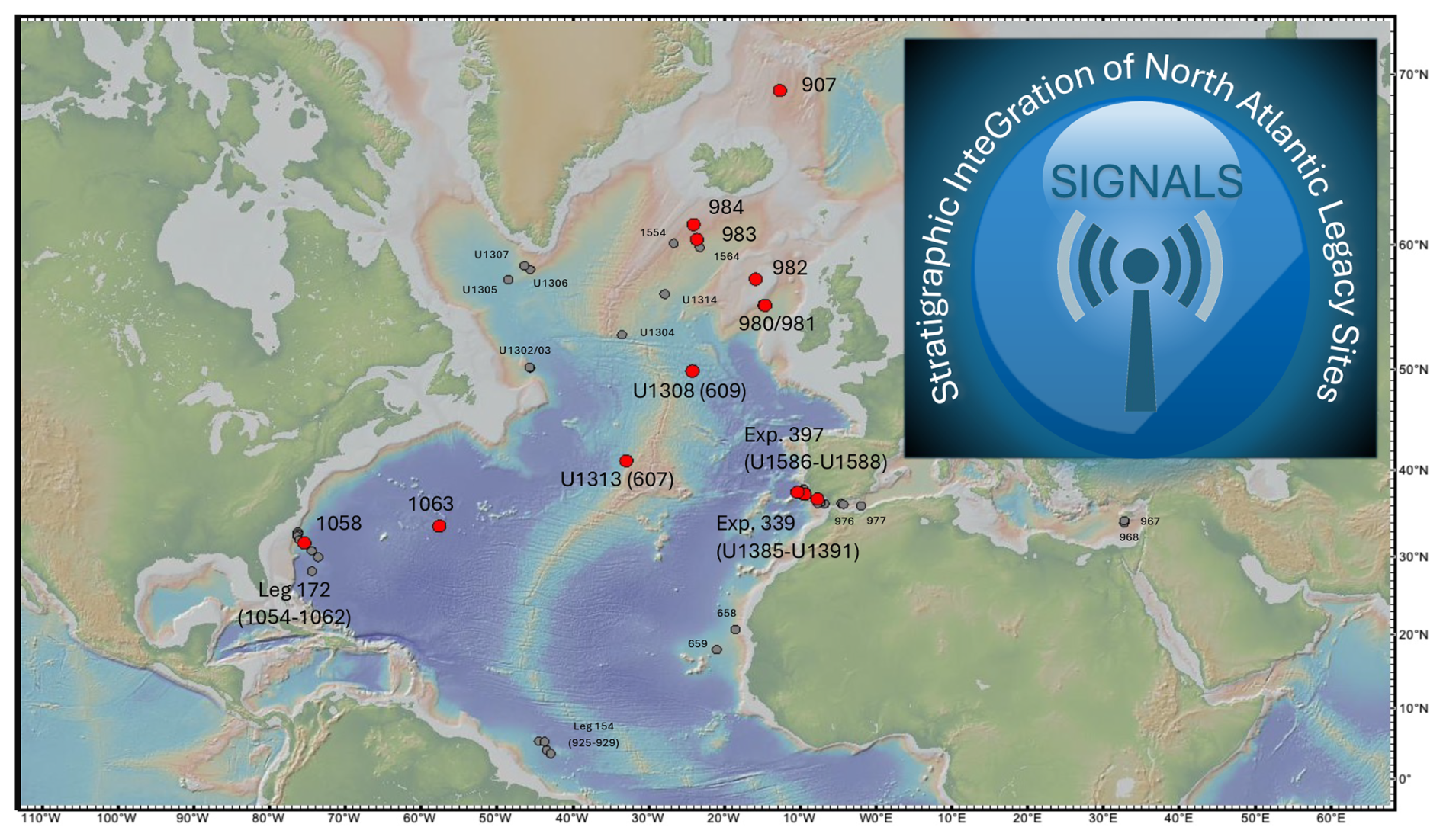
Figure 1SIGNALS sites in the North Atlantic. Red circles indicate anchor sites that will be used for establishing correlations to other sites (gray circles). All sites chosen have multiple holes drilled and spliced composite sections for stratigraphic continuity. Map was made with GeoMapApp (http://www.geomapapp.org, last access: 17 March 2026) (released September 2025).
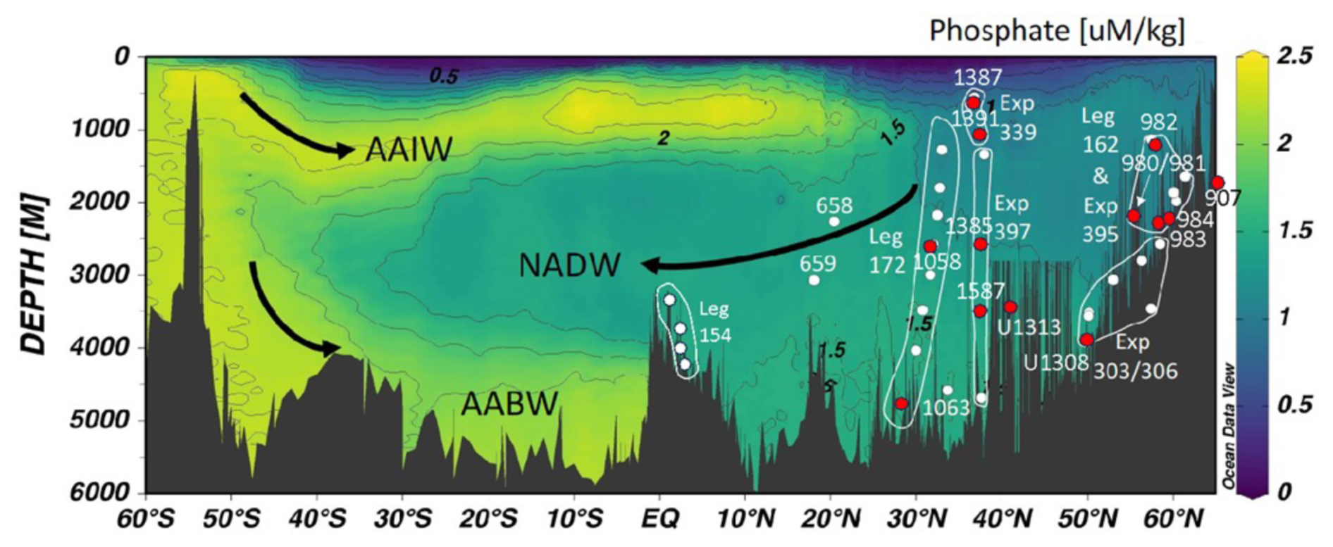
Figure 2Depth distribution of SIGNALS sites, spanning a range of water depths from 560 to 4600 m, intersecting each of the major subsurface water masses to reconstruct Atlantic intermediate- and deep-water circulation. The sites span the deep eastern and western Atlantic basins. White lines encompass ODP and/or IODP Legs and/or Expedition sites that were drilled as depth transects. Red circles represent anchor sites, as in Fig. 1. Schlitzer, Reiner, Ocean Data View, http://odv.awi.de, 2026.
Stratigraphic correlation and chronology are at the heart of the SIGNALS expedition because these are prerequisites for interpreting past climate history and identifying the forcings and dynamics of climate change. The expedition will synchronize records across multiple North Atlantic sites (Figs. 1 and 2) to answer key paleoclimate questions regarding orbital- and millennial-scale climate variability from the late Miocene to present. Climate variability will be placed in an orbitally tuned chronologic framework with robust estimates of stratigraphic and temporal uncertainty. The unified framework will provide the basis for the generation and synthesis of new and existing proxy data by members of the IODP3 Expedition 506S Science Team. It will also permit refinement of the ages of isotopic, biostratigraphic, and magnetostratigraphic chronologies across the North Atlantic and will interface with broader geochronological initiatives such as the Time Integrated Matrix for Earth Sciences (TIMES) (Westerhold et al., 2024).
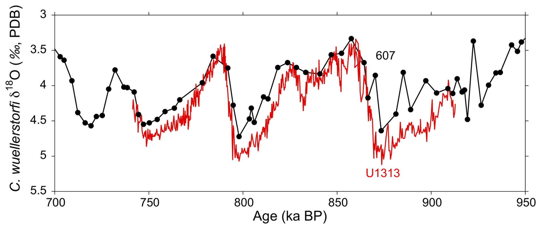
Figure 3Comparison of the original benthic oxygen isotope record of Site 607 (sampled at 15 cm resolution; Ruddiman et al., 1989) and the same interval at a higher resolution from Site U1313 (sampled at 1 cm resolution; Ferretti et al., 2015).
2.1 North Atlantic scientific drilling
Given the potential role of the North Atlantic in influencing the global climate system, scientific ocean drilling has focused on recovering deep-sea sediments that are suitable for the study of past climate change at orbital- and millennial-scale resolutions. In 1983, Deep Sea Drilling Project (DSDP) Leg 94 was a seminal expedition that used the Hydraulic Piston Corer (HPC) to recover continuous sequences from the Ice Rafted Detritus (IRD) belt of the North Atlantic (Ruddiman, 1977; Ruddiman et al., 1987), sometimes also referred to as the “Ruddiman IRD belt”. Leg-94 scientists recognized that sediment is invariably missing at core breaks and used core photographs to construct stratigraphic splices between holes (Ruddiman et al., 1987). The sites recovered during Leg 94 have become cornerstones of paleoceanographic research – so much so that three of these legacy sites (607, 608, 609) were re-occupied during Integrated Ocean Drilling Program (IODP) Expeditions 303 and 306 (U1313, U1312, and U1308, respectively). In particular, Site 607 (U1313) featured prominently in the early identification and dating of oxygen isotope stages in the late Pliocene to Pleistocene (Ruddiman et al., 1986, 1988, 1989; Raymo et al., 1989) and has been used in countless paleoceanographic studies. The resolution of the Site-607 isotope record is low by modern standards and fails to capture the full amplitude of the glacial–interglacial signal, the suborbital variability, or the true shape of the cycles (Fig. 3). New oxygen isotope results have been produced on only part of the U1313 record, focusing mainly on the Pleistocene to late Pliocene (e.g., Voelker et al., 2010; Ferretti et al., 2015; Bolton et al., 2010, 2018; Naafs et al., 2020; Catunda et al., 2021), and should be completed back into the Miocene considering the importance of this site for oxygen isotope stratigraphy.
Beginning in the early 1990s, observations of abrupt climate change during the last glacial period in Greenland (e.g., Dansgaard et al., 1993) sparked a search for similar variability in marine sediments of the North Atlantic. Millennial climate variability (MCV) in North Atlantic sediments was first identified in variations in sediment color and the abundance of the polar foraminifer Neogloboquadrina pachyderma sinistral (presented as % NPS) at DSDP Site 609 (Broecker et al., 1990; Bond et al., 1992, 1993). The continued quest for high-resolution records capable of resolving MCV led to the targeting of North Atlantic sediment drifts for drilling, which have elevated mean sedimentation rates in the range of 10–20 cm kyr−1. During ODP Leg 162, four sites (980, 981, 983, and 984) were drilled on sediment drifts south of Iceland (Feni, Björn, and Gardar Drifts). These sequences have yielded invaluable insight into the nature of MCV in the North Atlantic beyond the limits of the ice cores (Raymo et al., 1998; McManus et al., 1999; Raymo, 1999; Flower et al., 2000; Kleiven et al., 2003; Barker et al., 2021). Further south, sequences with high deposition rates were recovered during ODP Leg 172 in the northwest Atlantic between ∼ 30 and 35° N (Keigwin et al., 1998). Those sites were designed to trace orbital climate variability and MCV in the Gulf Stream region of the subtropical gyre and within the deep western boundary undercurrent (Thunell et al., 2002; Weirauch et al., 2008; Channell et al., 2012a; Billups and Scheinwald, 2014; Kaiser et al., 2019). IODP Expeditions 303 and 306 re-occupied some of the classic Leg-94 sites and further exploited other sediment drifts (particularly the Eirik and Gardar drifts) (Channell et al., 2006). It also drilled Orphan Knoll in the Labrador Sea which records Heinrich events related to surges of the Hudson Strait Ice Stream (e.g., Channell et al., 2012b). Most recently, International Ocean Discovery Program (IODP) Expedition 395 drilled contourite drift deposits on the flanks of the Reykjanes Ridge (Sites U1554 and U1562 on the Björn Drift and Site U1564 on the Gardar Drift) (Parnell-Turner et al., 2025).
Figure 4(A) Planktic (surface) and benthic (deep) oxygen isotope record of Site U1385 for the past 1500 kyr (Hodell et al., 2023, 2026b). (B) Planktic δ18O compared to the WAIS Divide methane record, which follows Northern Hemisphere temperature variations. (C) Benthic δ18O compared to the δ18O record from the WAIS Divide ice core, which reflects temperature variations in Antarctica (WAIS Divide Project Members, 2015).
North Atlantic sediment drifts have proved to be invaluable drilling targets for obtaining sedimentary sequences capable of resolving MCV over long periods of time. This strategy was extended to the SW Iberian Margin, including the Gulf of Cadiz and Portuguese Margin, which is a well-established location where sediments accumulate at high rates. IODP devoted three expeditions (339, 397, and 401) to recovering an unrivalled set of high-resolution late-Miocene–Holocene sequences, which, together, form a legacy archive. The sites form a complete depth transect from 560 to 4692 meters below sea level (m b.s.l.), spanning all of the major subsurface water masses of the eastern North Atlantic. At intermediate depths (∼ 500 to 1400 m b.s.l.), the Iberian Margin is particularly sensitive to fluctuations in Mediterranean Outflow Water, as recorded by sediment drift deposits of the Contourite Depositional System (CDS) (Hernández-Molina et al., 2006, 2016). Below 1400 m b.s.l., benthic foraminifer proxies are sensitive to changes in the temperature and ventilation of deep water, related to the relative influence of North-Atlantic- and Antarctic-sourced bottom waters. At the surface, variations in alkenone sea surface temperature (SST) and planktic foraminifer δ18O record changes in the North Atlantic subtropical gyre and resemble Greenland ice core temperatures, whereas benthic foraminifer δ18O variations resemble Antarctic ice core temperatures (Shackleton et al., 2000, 2004). In particular, IODP Site U1385 has provided a detailed record of MCV during glacial periods, spanning the last 1.5 Myr (Figs. 4 and 5), which is a critical interval for comparison to the Antarctic ice core recently recovered by the Beyond EPICA-Oldest Ice project (https://www.beyondepica.eu/en/, last access: 13 March 2026).
Previous work has documented the continuous nature of sedimentation at the sites targeted and provided high-resolution, non-destructive proxy measurements for initial stratigraphic assessments and alignments, generally reliable magnetic stratigraphies, and clear evidence of millennial and orbital variability in initial data sets (e.g., Grützner et al., 2002; Giosan et al., 2002; Channell et al., 2012a, b; Channell and Hodell, 2013; Obrochta et al., 2014; Grant et al., 2022). SIGNALS will build upon the large amount of high-quality work already produced on North Atlantic sites from the late Miocene to present by filling critical gaps at key sites with, for example, additional data such as X-ray fluorescence (XRF) scanning and additional proxy measurements.
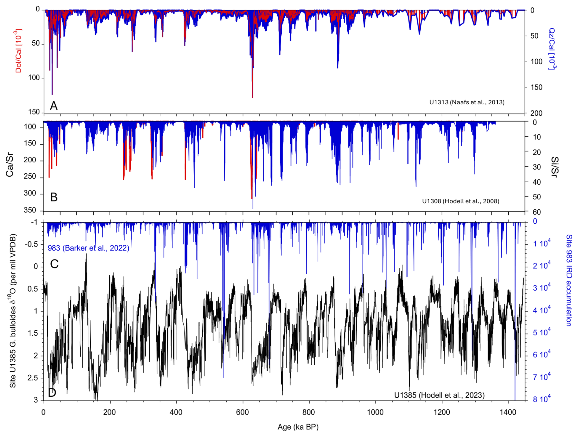
Figure 5Comparison of IRD records and proxies from Site U1313 at 41° N (A) (Naafs et al., 2013), U1308 at 50° N (B) (Hodell et al., 2008), and Site 983 at 61.4° N (C) (Barker et al., 2022) and the planktic foraminifer δ18O record of Site 339-U1385 at 37° N (D) (Hodell et al., 2023). Red proxy IRD signals in (A) and (B) indicate the presence of detrital carbonate, with the greatest peaks associated with Heinrich events.
2.2 Millennial climate variability
Quaternary marine stratigraphy has witnessed a progressive trend towards higher-resolution records spurred by the recognition of MCV in Greenland ice cores. With the move towards higher-resolution studies, a new calibre of sediment archives was required, with a high level of chronological precision. A number of IODP expeditions targeted locations where sedimentation rates were high enough to delineate millennial (or, in exceptional cases, centennial) climate variability.
Long records of IRD (or its proxies) exist for many sites across the North Atlantic, but correlation of individual events across the “Ruddiman IRD belt” remains uncertain. The occurrence of an IRD layer at a particular location is dependent on the proximity to the source and the transport of icebergs by wind and currents and their survivability, related to size, sea ice extent, and SST. The absence of IRD at one site does not necessarily preclude its presence and associated freshwater forcing elsewhere. For example, “Heinrich Events” that are rich in detrital carbonate derived from Paleozoic bedrock underlying the Hudson Strait (Heinrich, 1988; Broecker et al., 1992; Hemming, 2004) are not always present north of the IRD belt. To the south on the Iberian Margin and Bermuda Rise, IRD is only sporadically present, and, instead, stadial and/or interstadial changes are marked by changes in sediment composition and proxy micropaleontological and geochemical data (e.g., planktic foraminifer δ18O, SST, % N. pachyderma).
What is lacking is a synthesis of proxies (e.g., XRF, IRD, % N. pachyderma, planktic foraminifer δ18O, SST) that display MCV across sites in the North Atlantic. MCV at a single site may not be representative of the North Atlantic as a whole. Cores from different regions across the IRD belt may have different expressions of MCV in terms of both the magnitude and the temporal pattern of change (Fig. 5). Indeed, many long records of MCV are needed to determine the regional patterns of the time-varying climate signals across the North Atlantic.
2.3 Orbital chronostratigraphy
The recognition of pervasive orbitally induced cyclicity in sedimentation and paleoclimatic proxies revolutionized high-resolution stratigraphy and geochronology (Shackleton et al., 1990; Hilgen, 1991). Orbital stratigraphy (“astrochronology”) provides the backbone timescales for assessing rates of changes in the past and for understanding how changes in the Earth's orbit influenced climate. North Atlantic sediments often display lithological alternations suitable for orbital tuning (e.g., Wilkens et al., 2017; Crocker et al., 2022; Hodell et al., 2024). XRF and color image scanning are ideally suited for developing large, integrated databases where sites can be orbitally dated and correlated. The framework will be validated by stable isotopic, biostratigraphic, and magnetostratigraphic data. It is only with such careful stratigraphic work that important aspects such as regional versus basin-wide paleoceanographic changes can be assessed. The millennial-resolved sediment profiles are contained within the orbital chronostratigraphy in a nested hierarchy, which is pertinent to understanding how the climate system interacts across timescales.
ODP and IODP sites in the North Atlantic and Mediterranean have played a key role in the development of cyclostratigraphy. For example, long sequences recovered from the Ceara Rise (Sites 925–929: Wilkens et al., 2017), off NW Africa (Site 658: Crocker et al., 2022), and from the eastern Mediterranean (Site 967: Grant et al., 2022) have lithologic variations with strong orbital signals. More recently, the cores recovered from the Iberian Margin by IODP Expeditions 397 and 401 showed remarkable cyclicity that can be precisely tuned to the astronomical solutions.
2.4 Longer timescales (millions of years)
The North Atlantic includes several important gateways that control water exchange with other basins, including (1) the Mediterranean through the Betic–Gibraltar–Rifian seaways, (2) the Pacific through the Central American Seaway, and (3) the Norwegian–Greenland Sea via passages along the Greenland–Iceland–Scotland Ridge. The opening and closing of these gateways have been controlled by tectonics associated with compression in the Betic-Rif orogen, uplift of the Isthmus of Panama, and the Iceland plume.
The production of Mediterranean Outflow Water (MOW) adds heat and salt at intermediate depths to the Atlantic, which may affect the high-latitude meridional overturning circulation (Lozier and Stewart, 2008). Expedition 339 drilled the contourite depositional system to study the MOW in the Gulf of Cadiz and the southwestern Iberian Margin (Stow et al., 2013; Hernández-Molina et al., 2006, 2014). IODP Expeditions 397 and 401 recovered key sequences needed to study the closure of the Atlantic–Mediterranean gateway during the Messinian Salinity Crisis and its re-opening at the beginning of the Pliocene (Flecker et al., 2025).
IODP Expedition 395 drilled sediment drifts along the Reykjanes Ridge ridges south of Iceland (Parnell-Turner et al., 2025). The V-shaped ridges reflect changes in the crustal thickness and Iceland plume activity that result in uplift and subsidence of the Iceland–Faroe Ridge, which, in turn, controls deep-water exchange between the Norwegian–Greenland Sea and North Atlantic (Parnell-Turner et al., 2015). Sinnesael et al. (2025) identified a strong increase in Iceland Scotland Overflow Water at 3.6 Ma that may be linked to changes in thermohaline circulation and the early stages of the onset of Northern Hemisphere glaciation (oNHG) (McClymont et al., 2023).
A longstanding topic of discussion has been the effect that the closure of the Panamá Isthmus and the termination of water exchange between the Pacific Ocean and the Atlantic Ocean had on northward heat and salt transport via the Gulf Stream (Öğretmen et al., 2020). These changes have the potential to alter thermohaline circulation and potentially set the stage for the oNHG (e.g., Haug and Tiedemann, 1998; Driscoll and Haug, 1998). Similarly, enhanced production of Mediterranean Outflow from the mid-to-late Pliocene may have driven a sub-surface heat channel into the high-latitude North Atlantic, which delayed ice sheet growth until the end of the Pliocene (Kaboth-Bahr et al., 2021). SIGNALS has the potential to contribute to the longer-term tectonic forcing of climate background states from the late Miocene to present.
Stratigraphy is the backbone of paleoclimate research that underpins the interpretation of all proxy records. Without a robust stratigraphical framework, paleoenvironmental observations and interpretations remain ambiguous and of limited use. A precise stratigraphy is the main factor limiting our ability to determine phase relationships (lead- lags) among various variables in the atmosphere–ocean system, which is essential for testing causal mechanisms of global climate change.
IODP3 Expedition 506S aims to construct a comprehensive, 4-D stratigraphic framework to study climate variability across the North Atlantic on orbital and millennial timescales since the late Miocene. By integrating legacy data from ODP and IODP drill sites, we will refine stratigraphic correlations and chronologies and link proxy records across multiple locations along climatic and bathymetric gradients to evaluate the role of the North Atlantic in global ocean–climate interactions.
3.1 Paleoclimatic and Paleoceanographic (P) objectives
- P1.
Reconstructing North Atlantic climate evolution. We investigate how the Earth transitioned from the warm Miocene to the glacial–interglacial cycles of the Pleistocene, with a focus on orbital-scale climate variability and feedbacks in relation to forcing by tectonics and greenhouse gases.
- P2.
Causes of cyclic sedimentation. We develop process models to understand how orbitally driven climatic processes are expressed as cycles in the stratigraphic record of each site. We seek to understand how cyclicity evolved at each site or region as background conditions changed from the late Miocene to present.
- P3.
Understanding millennial-scale climate variability (MCV). We reconstruct the timing and spatial patterns of abrupt climate change since the late Pliocene intensification of Northern Hemisphere glaciation (iNHG) and their relationship to a changing AMOC.
- P4.
Climate variability across timescales. We characterize the interactions of millennial, orbital, and longer timescale climate variabilities as orbital, glacial, and tectonic boundary conditions changed from the late Miocene onwards.
- P5.
Linking surface, intermediate-, and deep-ocean changes. We examine how variations in SST, IRD deposition, and deep-water circulation influenced past climate shifts and carbon cycle dynamics. How did Mediterranean Outflow Water and AMOC affect heat and salt transport in the ocean and what was the role of the North Atlantic in triggering or amplifying global climatic changes?
- P6.
Long-term carbon cycle. We document pelagic CaCO3 export production and dissolution since the late Miocene, including interactions with evolutionary and paleoecological dynamics of calcifying phytoplankton.
Table 1List of sites with basal ages of the section, available stratigraphic control, and average sedimentation rate. All sites will be incorporated into the 4-D stratigraphic framework.
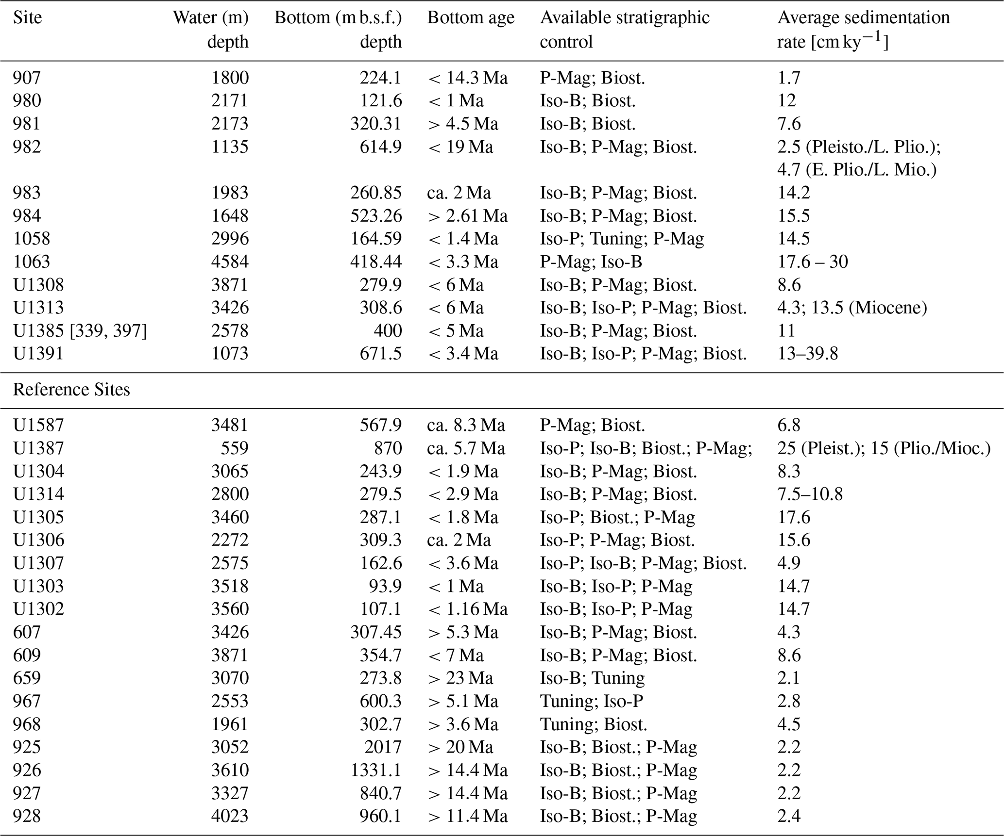
Iso-B/P: benthic/planktonic foraminifera stable isotope data. Biost.: Biostratigraphic data. P-Mag: Paleomagnetic chronostratigraphy.
3.2 Methodological (M) objectives
- M1.
Data collection. We fill data gaps at key anchor sites and provide robust frameworks to refine the existing biostratigraphic and paleomagnetic stratigraphies.
- M2.
Construct 4-D framework. We establish a synchronized, multi-proxy stratigraphic framework for North Atlantic sites, including uncertainty estimates in stratigraphic correlations and age models.
- M3.
Assess temporal resolution. We evaluate the limits of temporal resolution at each site given varying sedimentation rates, bioturbations, and sampling frequencies.
- M4.
Marine–ice–terrestrial correlations. We precisely correlate climate signals in marine sediment cores in relation to the polar ice cores and terrestrial records to link oceanic, atmospheric, and terrestrial climate and environmental changes.
- M5.
Advance stratigraphic correlation techniques. We develop and apply automated signal correlation algorithms to synchronize sediment records at orbital and suborbital timescales, along with estimated uncertainties.
- M6.
Core imaging, computer vision, and deep learning. We process high-resolution core images using neural networks to automatically segment and remove unwanted disturbances such as those resulting from bioturbation, redox changes, and core disturbance.
- M7.
Links to other initiatives. We contribute the North Atlantic data to global ocean data integration initiatives and data–paleoclimate modeling initiatives (TIMES, PAGES working groups, PMIP-Interglacials, etc.).
TIMES (Time Integrated Matrix for Earth Sciences) is a global program with the aim of synchronizing age models for particularly important geological climate records from the last 100 Ma (Westerhold et al., 2024). The current PAGES (Past Global Changes) working groups (https://pastglobalchanges.org/science/current-wg, last access: 13 March 2026) most relevant to the SIGNALS expedition are CVAS (Climate Variability across scales) and PlioMioVAR (Pliocene and Miocene climate variability over glacial–interglacial timescales).
3.3 Alignment to 2050 Science Framework
These goals address the Strategic Objectives (SOs) posed by the 2050 Science Framework, including Earth's Climate System (SO3), Feedbacks in the Earth System (SO4), Tipping Points in Earth History (SO5), and Global Cycles of Energy and Matter (SO6). Furthermore, SIGNALS is relevant to several of the Enabling Elements of the science plan, including Land to Sea (EE2) through the correlation of terrestrial and ice core sequences in relation to marine sediment records and Technology Development and Big Data Analytics (EE4) through proposed machine learning applications and automated data collection. SIGNALS will also train a new generation of early-career scientists in methods of modern stratigraphy and artificial-intelligence (AI)-assisted data generation (EE1).
4.1 Targeted legacy resources
The strategic goals of the SIGNALS expedition will be achieved using legacy core material and data covering a wide spatial and bathymetric range in the North Atlantic (Figs. 1 and 2; Table 1). We will first construct the stratigraphic framework and chronologies of North Atlantic legacy sites, followed by the integration of existing and new proxy data. The selected ODP and IODP sites range from 4.2 to 61.4° N latitude and from 74.5° W to 32.8° E longitude (Fig. 1), across the modern Polar, Subpolar, and Subtropical gyres and the glacial IRD belt of the North Atlantic. The sites span a range of water depths from 560 to 4600 m (Fig. 2) and are well placed to study how changes in intermediate- and deep-ocean circulation affect climate. For more recent IODP expeditions, we will interact and collaborate with the respective science parties to avoid overlap with ongoing research projects.
We have identified a list of sites where stratigraphic synchronization can be accomplished in a 3-year period (Table 1). Our choice of priority sites was guided by the location, age, and continuity of the stratigraphic section; availability of data from previous work; and gaps in data and/or knowledge. All sites will be incorporated into the SIGNALS stratigraphic framework, but the priority sites merit additional analysis (at minimum XRF and image processing). Some sites already have extensive work completed, including stratigraphic reanalysis and chronology back into the Pliocene or Miocene, and are designated as reference sites (Table 1). We have compiled information on all known post-cruise XRF data and identified gaps that need to be filled. Flexibility in site priority is important because it may become clear that some sites already have enough data and that others require additional work once the expedition begins. We recognize that the initial scope of work is limited to a 3-year period, but the SIGNALS expedition is a seed project that we anticipate will continue to grow beyond the current funding period as new materials and resources become available. We expect that the 4D stratigraphic framework developed as part of SIGNALS will be used to address many other research questions involving time series or time slice approaches (e.g., synchrony or diachrony of biostratigraphic events).
Multiple holes were drilled at each of the anchor sites, and shipboard composite sections were established, suggesting complete recovery of the sequences; however, revisions of splices are likely to be necessary for some sites – beyond those already known (e.g., U1313: Naafs et al., 2020; U1385: Hodell et al., 2015; U1387: Voelker et al., 2018; U1391: Abrantes et al., 2017). We will focus on archive halves (including existing u-channels of archive halves) for stratigraphic correlation using non-destructive methods (e.g., XRF scanning, core images, physical properties, paleomagnetism), supplemented by available measurements on discrete samples (e.g., stable isotope, biostratigraphic, and magnetostratigraphic signals and datums). Where material is unavailable and sediment has been depleted from primary splice sections due to heavy sampling, alternate splices will be constructed.
The SIGNALS strategy is to construct the 4-D stratigraphic framework of integrated North Atlantic sites that will then be used to host proxy data for paleoclimatic and paleoecological interpretation. In the preparation of the expedition and implementation plan, we have prepared asset tables listing the core materials needed to construct the framework, mainly consisting of new XRF analysis, line scan imaging and stable isotopes needed to supplement existing data, and images and/or physical-property measurements stored in the LIMS (https://web.iodp.tamu.edu/LORE/, last access: 13 March 2026) and JANUS (http://www-odp.tamu.edu/database/, last access: 13 March 2026) databases. Many of the high-priority sites have been partially XRF scanned, and we propose filling data gaps to the extent possible in the 3-year period. Existing u-channels of archive halves will be scanned at other XRF facilities to the extent possible to decrease pressure on the Bremen Core Repository (BCR) instrumentation (however, no new u-channels will be taken). Line scan digital images will be captured for older ODP cores. Individual sample requests by IODP3 Expedition 506S Science Team members will be made for any additional discrete samples needed for biostratigraphic or other proxy data generation. We will use samples previously taken whenever possible, and any new samples will be taken from working or non-permanent archive halves (including alternative splices).
4.2 Sampling and data-sharing strategy
All applicants applying for membership with the SPARC Expedition Science Team should refer to the Sample, Data, and Obligations Policy (https://iodp3.org/documents/sample-data-obligations-policy/, last access: 13 March 2026). This document outlines the policy for distributing scientific ocean drilling samples and data to research scientists, curators, and educators. The document also defines the obligations that recipients of samples and data incur. The SPARC Co-Chief Scientists, in discussion with the Curators of the Core Repositories, will work with the entire SPARC Expedition Science Team to develop a formal Implementation Plan once the team is assembled following the open Call for Participation. The Implementation Plan will include the following:
-
detailed plans for collaboration between SPARC Expedition Science Team members and discussions of how this will be facilitated and managed to promote focused research and progress (e.g., plans regarding in-person sampling at the Core Repositories and the frequency of dedicated virtual and in-person meetings of the Science Team) and how results will be disseminated;
-
outlining discussions held with the Curators of the Core Repositories regarding the availability of core materials and plans for accessing and using repository facilities;
-
plans for obtaining additional funding to complete the research if this cannot be achieved using the EUR 300 000 SPARC award;
-
a Gantt chart showing the timelines for the research, key milestones, and deliverables.
Every member of the SPARC Expedition Science Team will be obligated to carry out scientific research for the expedition and to publish the results by contributing to the production of the SPARC Expedition Summary and Results in the Proceedings of the International Ocean Drilling Programme and by publishing in other scientific journals. All SPARC Expedition Science Team members are required to submit their own detailed research plans and associated sample and/or data requests via the Sample, Data, and Research Request Manager (SDRM) system (https://web.iodp.tamu.edu/SDRM/#/, last access: 13 March 2026) in order to receive samples to work on. However, sample requests must be provided to the SPARC Expedition Co-Chief Scientists prior to submission to allow them to coordinate sampling efforts, avoid duplications, and resolve sampling conflicts between Science Team members. However, subsequent sharing of allocated samples between SPARC Expedition Science Team members to facilitate integrated analyses will be encouraged.
4.2.1 Virtual platform
Previous IODP expeditions have included a physical platform (R/V JOIDES Resolution, D/V Chikyu, other mission-specific platforms) where the expedition science team could interact, collect data, share experiences, and work towards accomplishing expedition goals. For IODP3 Expedition 506S, we propose a dedicated virtual workspace that will function as the expedition's platform – providing real-time communication, coordination, and data-sharing infrastructure for the Science Team. Slack® (https://slack.com, last access: 13 March 2026) is the virtual platform of preference because it offers a dynamic, searchable platform for real-time messaging, structured discussion threads, file exchange, and integration with analytical and data management tools. It will ensure that all members remain connected across time zones and institutions, fostering efficient, transparent, and inclusive collaboration.
This digital environment will provide structured channels for each working group (e.g., stratigraphic correlation, XRF data, image analysis, machine learning, chronology) for focused discussions and data sharing. Expedition documentation, meeting notes, and draft figures will be archived within relevant channels to create a centralized, searchable record of progress. Slack® will be integrated with cloud storage platforms (e.g., shared Google® Drive or institutional repositories) to facilitate data sharing and collaborative editing of documents. The Slack® workspace will also host a regularly updated expedition dashboard summarizing current milestones, deadlines, and deliverables to maintain momentum and a visible timeline.
Regular virtual meetings will be organized via video conference platforms (e.g., Zoom® or Microsoft Teams®) and announced through Slack®. These meetings will focus on reviewing progress, discussing preliminary results, and aligning analytical efforts across teams.
Slack® will thus underpin the coordination and synthesis of the overall research effort by
-
enabling rapid communication and troubleshooting across distributed teams;
-
providing a persistent record of decisions and workflows;
-
facilitating cross-disciplinary discussion between stratigraphers, developers, and data scientists;
-
ensuring all science team members have equitable access to information and updates;
-
supporting onboarding and training of early-career scientists through dedicated Q-and-A and resource channels.
This virtual collaboration model ensures that the collective expertise of the international SIGNALS Science Team is effectively harnessed, coordinated, and drawn together into a coherent research program, culminating in shared publications, data products, and open-access computational tools.
4.2.2 Virtual expedition organizational structure
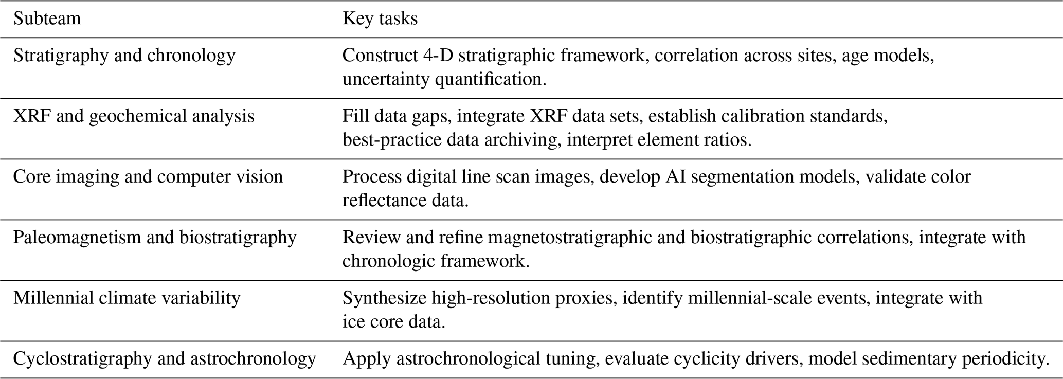
The SIGNALS Virtual Science Operations Environment will be organized around working groups with stratigraphic correlation as its central theme, supported by cyclostratigraphy, magnetostratigraphy, biostratigraphy, and stable isotope-stratigraphy. Participants are likely to be involved with several working groups with activities coordinated through the virtual Slack® workspace, linking scientists, data systems, and analytical tools in real time. The working groups will be supported by the science management team (SMT), data collection and management, the Bremen Core Repository (BCR), outreach, grant administration, training, and the development of advanced tools and technologies.
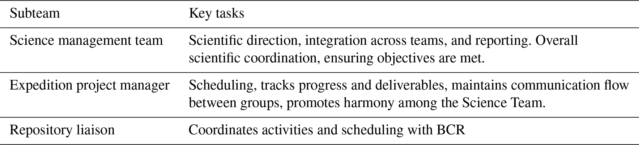
The Leadership and Coordination Group will consist of a science management team, project manager, and repository and will be responsible for coordinating the expedition and fostering communication within and among the working groups (Table 2).
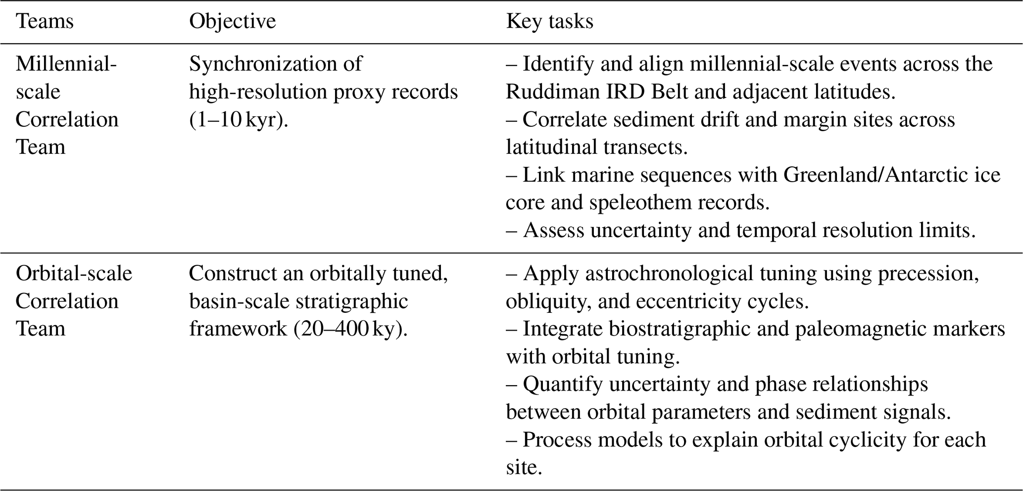
The Stratigraphic Correlation Working Group is the scientific heart of the expedition. It will be divided into two nested teams addressing different temporal scales but operating within a shared framework (Tables 3 and 4).
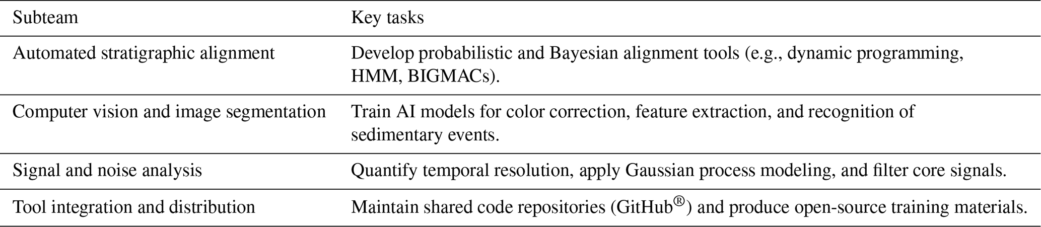
The Advanced Method Development Group is the technical part of SIGNALS. It will develop automated, quantitative, and reproducible tools that underpin stratigraphic correlation. This group works jointly with both correlation teams to ensure methodological consistency and reproducibility (Table 5).
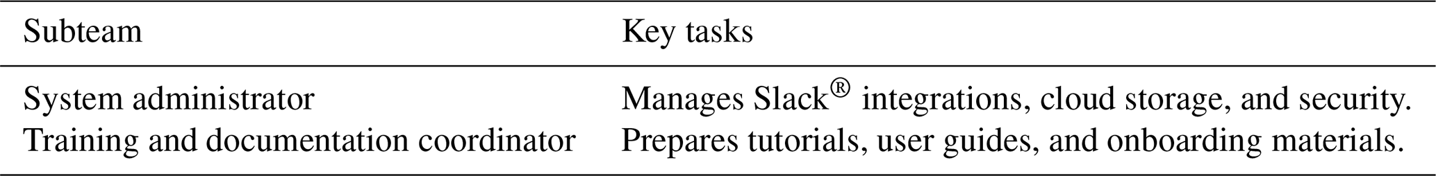
The Technical and Analytical Support Group will maintain digital infrastructure and visualization capabilities and will ensure that all analytical data and tools are well documented and that training resources are available to support all scientific and data workflows (Table 6).
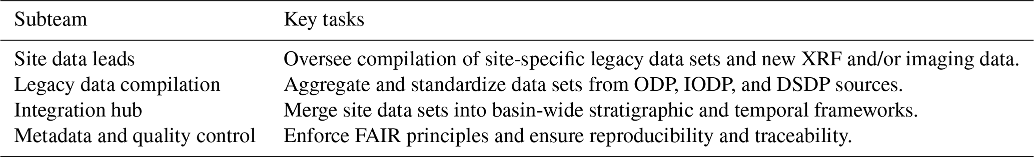
The Data Management and Integration Group will serve as the backbone of the SIGNALS network, compiling, standardizing, and integrating data from legacy and new analyses (Table 7).
The Outreach and Communication Group will disseminate scientific outputs, promote open science, and maintain community engagement (Table 8).
The Administration Group will provide financial, institutional, and logistical oversight through the grant-holding host institution, ensuring accountability, transparency, and operational support (Table 9).
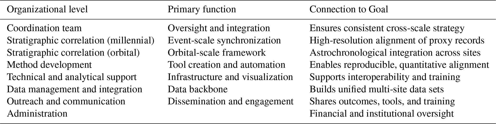
In summary, these groups will work together to accomplish the main scientific goals of IODP3 Expedition 506S (Table 10).
4.3 Analytical techniques and methodologies
Stratigraphic correlation (between holes and among sites) will be accomplished mainly using non-destructive, automated measurements used to characterize the physical properties and elemental composition of sediment cores (e.g., line scan images, color reflectance, gamma ray attenuation porosity evaluation, magnetic susceptibility, natural gamma radiation, XRF scanning, and down-hole logging).
4.3.1 XRF scanning
The introduction of commercial core scanning XRF instruments in 2003 revolutionized the stratigraphic correlation of ODP and IODP cores by allowing non-destructive analysis of the elemental composition of sediment at a high spatial resolution. In addition, XRF elemental ratios provide vital information for detecting IRD layers in North Atlantic cores (e.g., Hodell et al., 2008; Channell et al., 2012b), identifying MCV (Hodell et al., 2023) and orbital variations in sediment composition used for astronomical tuning. The JOIDES Resolution did not have an XRF core scanner on board, and, thus, data collection was a post-cruise research activity. Many of the key legacy North Atlantic sites have been partially scanned, but some remain incomplete. We compiled the information on existing published and other available XRF data (to our knowledge) and propose filling these data gaps by scanning cores for the high-priority legacy sites (to the extent possible in a 3-year period).
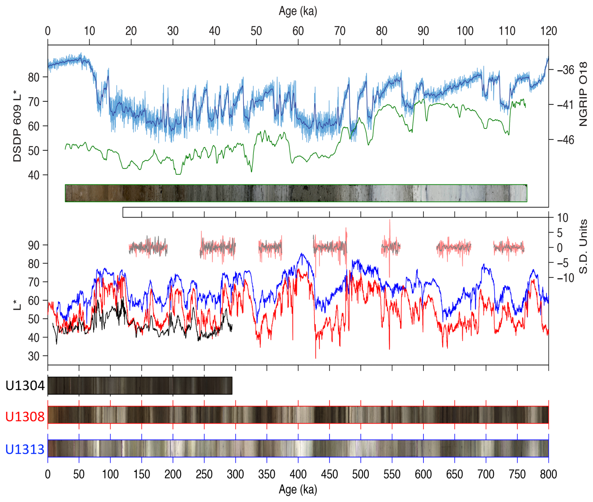
Figure 6Top panel: correlation of sediment lightness (L*) at Site 609 (later redrilled as Site U1308) to North Greenland Ice Core Project (NGRIP) δ18O with a composite image created from the “core table” photograph and manually corrected for parallax. Middle panel: comparison of sediment lightness among Sites U1313 (41° N, blue), U1308 (50° N, red), and U1304 (53° N, black). (Lower) Core images of the three sites. Note the smoothing of the 609 L* data relative to millennial variability recorded in the NGRIP δ18O record, which can be simulated using a low-pass filter of the NGRIP record (see Fig. 8).
4.3.2 Core images
Ever since ODP Leg 200, core section images have been captured using digital line scanners. Digital images provide the highest-resolution (0.1 mm) data that we will ever collect, yet this resource remains terribly underutilized (exceptions include Wilkens et al., 2017, and Crocker et al., 2022, among others). However, bioturbation, voids, cracks, redox zones, and drilling disturbance often result in noisy color signals that complicate their use in stratigraphic correlation. Advances in the field of computer vision offer the potential to automatically correct for these disturbances and vastly improve the signal-to-noise ratio of color data (e.g., Fazekas et al., 2017; Obrochta et al., 2020, 2022). SIGNALS will use deep-learning-based tools for processing line scanner core images to produce nominally undisturbed color records along the composite sections of each site (see Sect. 4.3.7 and 4.3.8). These ultra-high-resolution data will be invaluable for correlating between holes at the same site, correlating between sites (e.g., Obrochta et al., 2014; top panel of Fig. 6), and assessing the stratigraphic and temporal resolution of each site.
Prior to the introduction of a digital imaging system aboard the JOIDES Resolution, core photographs (digital or film) were taken of the sections of each core using a “core table” for older DSDP, ODP, and IODP expeditions. Although color information can be recovered from these images (e.g., Fig. 6 and Wilkens et al., 2017), inconsistent lighting and parallax make standardization difficult. Archive halves of the high-priority sites will be scanned in Bremen using a digital line scan camera system and a computer-vision-based system, developed at Akita University (Japan), which contains additional processing features.
4.3.3 Evaluation of composite sections
Shipboard stratigraphic correlation is often done under rushed conditions using physical-property data measured at varying resolutions. Post-cruise reanalysis of shipboard stratigraphic splices inevitably uncovers errors that include skipping or duplication of parts of the sequence. Furthermore, standard ODP and IODP practice involves shifting entire cores by a fixed distance and splicing sections from different holes together to form a composite section. Using this approach, cores between holes are correlated only at the splice tie points as no stretching or squeezing is permitted with the IODP Correlator software used on board at the time of the expeditions. The splice continues down-hole and accumulates offsets so that the composite depth grows significantly relative to the driller's depth, creating an artificial depth scale (meters composite depth or core composite depth below seafloor). As part of the SIGNALS project, we will use XRF scanning, core image, and physical-property data to review the splices for each site and to stretch and squeeze sections between holes to produce a revised composite depth scale (Wilkens et al., 2017). Rigorously assessing the reliability of existing composite sections is important for developing off-splice composites where primary splice sections are depleted from sampling. Data analysis may also help prioritize sites or stratigraphic intervals where more time- and resource-consuming analyses are needed (e.g., XRF, stable isotopes, SST proxies, refining biostratigraphy or magnetostratigraphy). Additionally, down-hole logs (where available) will be integrated into composite section generation (Lofi et al., 2016; de Vleeschouwer et al., 2017).
A few examples of the benefits of high-resolution stratigraphic re-analysis illustrate the potential progress to be made. Drury et al. (2018) conducted XRF scanning of ODP Site 982, a North Atlantic site containing key records of middle Miocene to present oceanographic change. The precision of XRF data allowed them to convincingly show that the shipboard splice contained both significant gaps and a major omission. The end result was a robust isotopic record that differed by several 100 kyr from what was originally thought. Wilkens et al. (2017) reviewed the splices of Leg-154 sites drilled on the Ceara Rise. Although most changes were minor, several were large enough to affect age models based on orbital tuning. Similarly, Hilgen (2025) recently used XRF scans to revise the stratigraphy of Pacific IODP Site U1337 and showed that the original splice was in error by some 400 kyr. While such large errors may not be the rule, we cannot at present align most North Atlantic records to the level of 5 kyr precision (orbital-scale processes) or better (scale of millennial processes).
4.3.4 Integrated millennial-scale stratigraphy across the North Atlantic
SIGNALS will correlate millennial events in high-sedimentation-rate sites across the North Atlantic (Fig. 1). We will synchronize these events where possible with the polar ice core records in Greenland and Antarctica (similar to approaches shown in Fig. 3) and with speleothem records from Europe and Asia using a probabilistic algorithm for continuous proxy–data alignment (Muschitiello et al., 2020; Muschitiello and Aquino-Lopez, 2024; Lee et al., 2023). As shown in Fig. 5, a similar signal is recorded in the North Atlantic across a wide range of latitudes. Some sites (e.g., 983, 1058, U1308, U1385) have very long, millennial-resolved proxy records that extend back to the early Pleistocene (Barker et al., 2021, 2022; Hodell et al., 2015, 2023; Weirauch et al., 2008; Billups and Scheinwald, 2014), but the millennial events at these sites have yet to be precisely correlated across latitudes. Integrating proxy records of MCV across the North Atlantic is vital for linking low-latitude and high-latitude processes and evaluating the role of freshwater forcing in MCV, as well as their potential impact on regional and global climate (Fig. 5). Indeed, the leading hypothesis to explain MCV is changes in the AMOC because of its sensitivity to mode jumps that can be triggered by changes in the surface water density in North Atlantic source areas of deep-water formation. Testing this hypothesis requires a network of integrated marine records across the North Atlantic (Fig. 1).
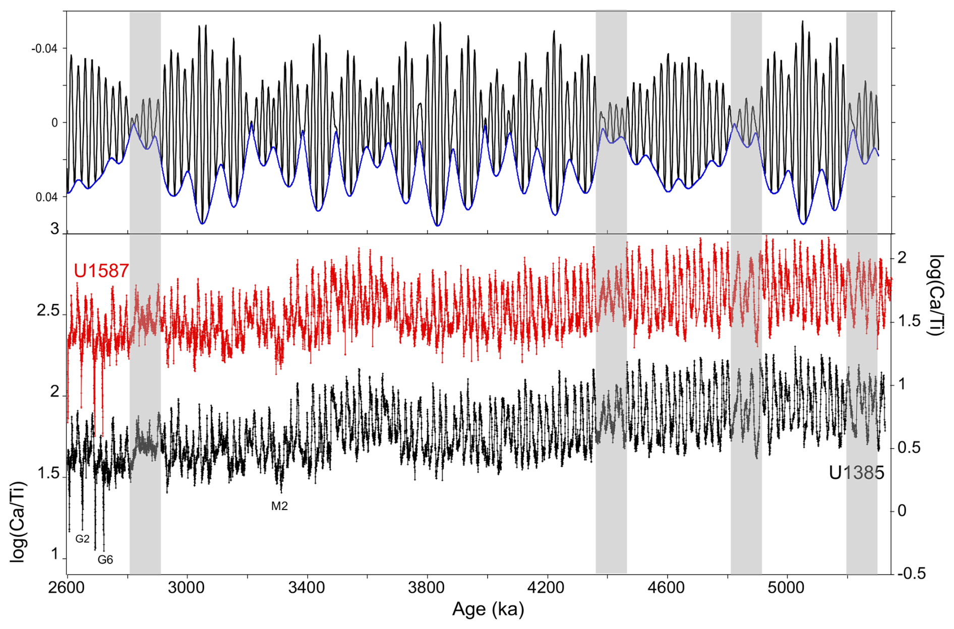
Figure 7Ca/Ti record measured by XRF at Sites 397-U1385 (black line; Hodell et al., 2026a, b) and U1587 (red line; Alvarez Zarikian et al., 2026) tuned to a precession (black line) whose amplitude is modulated by eccentricity. Gray shading highlights the prominent eccentricity minima.
4.3.5 Cyclostratigraphy and geochronology for the Quaternary–late Miocene
Most of the sedimentary sequences obtained through scientific ocean drilling in the Atlantic contain striking evidence of cyclicity paced by orbital variations. In particular, lithological cycles often mimic the eccentricity modulation expected from precessional forcing (Fig. 7), far more than might be expected from stable isotopic profiles that are typically dominated by 41 kyr obliquity cycles for most of the Miocene and Pliocene (Lisiecki and Raymo, 2005). The strong precession cycle is a boon to stratigraphy because the eccentricity-modulated signal is a far better tuning target than the rather monotonic obliquity signal (Shackleton et al., 1990; Liautaud et al., 2020). In addition, because the precessional period is 50 % shorter than obliquity, successful tuning to this rhythm inherently increases temporal precision. With a purely precession-tuned timescale, the timing of glacial terminations and inceptions in the benthic δ18O signal can be independently assessed relative to changing obliquity.
A major goal will thus be to improve the chronology of both millennial- and orbital-scale signals by means of astrochronology (see Meyers, 2019). Astrochronological tuning of sedimentary cycles promises to improve the dating of stable isotope signals, which often are quite noisy and difficult to tune or align precisely with the Pliocene prior to the iNHG. Improvements in dating will yield fresh insights into the pacing of cryospheric variation, North Atlantic circulation, benthic CO2 storage, and paleoecology and evolution.
Cyclicity in Atlantic sedimentation also raises important questions about the causal mechanism(s) by which orbitally induced changes in insolation are conferred to the sediment record. Potential processes could involve oscillations in carbonate production (e.g., latitudinal shifts in ecological provinces and/or shifts in dominant plankton groups, Lawrence et al., 2013; McIntyre et al., 1989); the corrosivity of bottom water in relation to carbonate (dissolution); and dilution by clastic material, which may be erosional, eolian, fluvial, or ice-rafted in origin (Grützner and Higgins, 2010; Hodell et al., 2008; de Castro et al., 2021; Crocker et al., 2022; Sinnesael et al., 2025). Each of these processes may change over time, along with the evolution of global climates and the growth of Northern Hemisphere ice sheets. Thus, the origin of Atlantic lithological cycles is a paleoclimatic, as well as stratigraphic, problem that needs to be explored.
The IODP3 Expedition 506S Science Team will focus on dissecting the origin of stratigraphic cycles by synthesizing existing measurements and generating new measurements to fill gaps (e.g., SST, stable isotopes, microfossil assemblages and preservation, nannofossil assemblages, detrital (clay) mineralogy and isotope geochemistry, deep-water chemical proxies) that will lead to process-based models to explain how orbitally driven climatic processes are expressed as cycles in the stratigraphic record of each site.
4.3.6 Climate interactions across timescales
Results from IODP Expedition 397 suggest that MCV began with the iNHG in Marine Isotope Stage (MIS) G6 (∼ 2.75 Ma) in the latest Pliocene (Fig. 7) and remained a persistent feature of glacial climate throughout the Quaternary (Hodell et al., 2026a, b). The MCV is nested within the orbitally driven glacial–interglacial cycles. Understanding how the climate system interacts across these timescales (both upscale and downscale) is important for understanding Ice Age climates. How do processes on orbital timescales affect MCV and, in turn, how does MCV affect orbital timescales? For example, orbital configuration may modulate the amplitude and/or frequency of MCV. Some MCV may be related to the harmonics or combination tones of the orbital cycle (Hagelberg et al., 1994; Ferretti et al., 2015). MCV provides a source of deterministic noise on orbital timescales that may be important for phase locking the climate system to the orbital cycles. As part of SIGNALS, we will apply higher-order time series techniques (bispectral analysis, etc.) to better understand energy transfer mechanisms across a broad range of timescales (e.g., Liebrand and de Bakker, 2019; Liebrand et al., 2023).
Evolving Earth boundary conditions might also underlie mode switches (frequency and/or amplitude) in the expression of orbital cyclicity. Important candidates to be investigated by SIGNALS include the late Miocene global cooling and rise on land of grassland and savanna ecosystems (Herbert et al., 2016), the isolation of the Mediterranean from ∼ 6.5 to 5.235 Ma (Messinian Salinity Crisis), uplift of the Isthmus of Panama (Haug and Tiedemann, 1998; O'Dea et al., 2016), and subsidence of the Greenland–Iceland–Scotland Ridge (Robinson et al., 2011; Parnell-Turner et al., 2015; Sinnesael et al., 2025). The expression of these events in North Atlantic temperature gradients, heat transport, and deep and intermediate circulation is not well known.
4.3.7 Long-term carbon cycling
The SIGNALS stratigraphic framework will permit the study of the carbon cycle and how it may have influenced climate evolution during the transition from the relatively warm climates of the late Miocene–Pliocene to the Quaternary icehouse (Westerhold et al., 2020). Once oxygen isotope records are synchronized, comparisons of carbon isotope signals among sites located in different subbasins and depths (Fig. 2) can reveal long-term trends in carbon mass balance and deep-water circulation and ventilation. Because both color lightness and XRF (e.g., Ca/Ti) are highly correlated to carbonate content (weight percent CaCO3) of the sediment, these measurements can be used to accurately estimate carbonate accumulation rates. Studying the long-term patterns of carbonate production and dissolution across North Atlantic sites will allow for the assessment of the role of orbital forcing (e.g., long eccentricity cycles) in pelagic carbonate export and its possible relation to calcareous nannofossil evolution (Beaufort et al., 2022; González-Lanchas et al., 2023). Eccentricity, with long periods near 100 and 400 kyr, is known to influence long-term carbon cycle changes by pacing global climate and influencing monsoon intensity, chemical weathering, and ocean nutrient supply. The timescale developed by SIGNALS will permit an evaluation of these long eccentricity cycles in proxies of the carbon system.
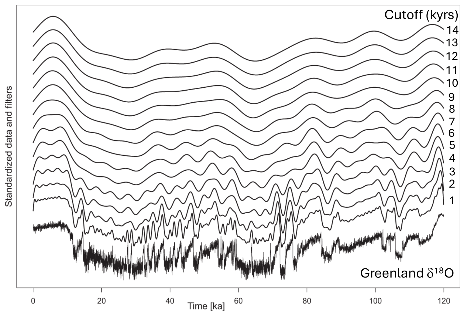
Figure 8Low-pass filters of the Greenland δ18O record with cut-off frequencies from 1 to 14 kyr (increasing from bottom to top). Sedimentation rate, bioturbation, and sampling frequency act to smooth paleoclimatic signals. Note the signal distortion marked by attenuation and the complete loss of high-frequency variations with increasing cut-off frequency, simulating a decreasing sedimentation rate and increasing bioturbation (adapted from Zeeden et al., 2020, under Creative Commons Attribution 4.0 International License (https://creativecommons.org/licenses/by/4.0/, last access: 13 March 2026).
4.3.8 Assessing signal-to-noise ratio, stratigraphic alignments, and temporal resolution
Sediment profiles represent low-pass filters of climatic and/or oceanographic signals whose cut-off frequency is dependent upon sedimentation rate, bioturbation, compaction, coring and/or drilling disturbance, and sampling frequency (Anderson, 2001; Zeeden et al., 2020; Fig. 8). Before signals can be correlated between sites and interpreted, it is essential to understand how primary stratigraphic signals are smoothed (reduced amplitude) or distorted by these processes. This will be assessed empirically by evaluating the coherency of signals within and between sites (e.g., Chapman and Shackleton, 1998) and using numerical bioturbation models (Hülse et al., 2022; Trauth, 2013).
All stratigraphic and paleoclimatic signals have uncertainties (“errors”). These uncertainties can blur the true amplitude of paleoclimatic variability, distort the alignment of records in depth and time, and limit the detection of the orbital-scale periodicity that is pervasive in marine records. We will take advantage of the new tools being applied to signal analysis under the umbrella of “Gaussian process” (GP) modeling (see Rasmussen and Williams, 2006), a form of non-parametric estimation or data prediction. This approach underpins advances in artificial intelligence (AI) and machine learning and brings about a rigorous method for identifying patterns in data with noise. The GP process is very effective at assessing the signal-to-noise ratio of proxy data. It can be used on both equally and unequally spaced data. For noisy data, the prediction value of adjacent points is poor, and the most likely estimate will lie near the mean of the measurements (Fig. 9).
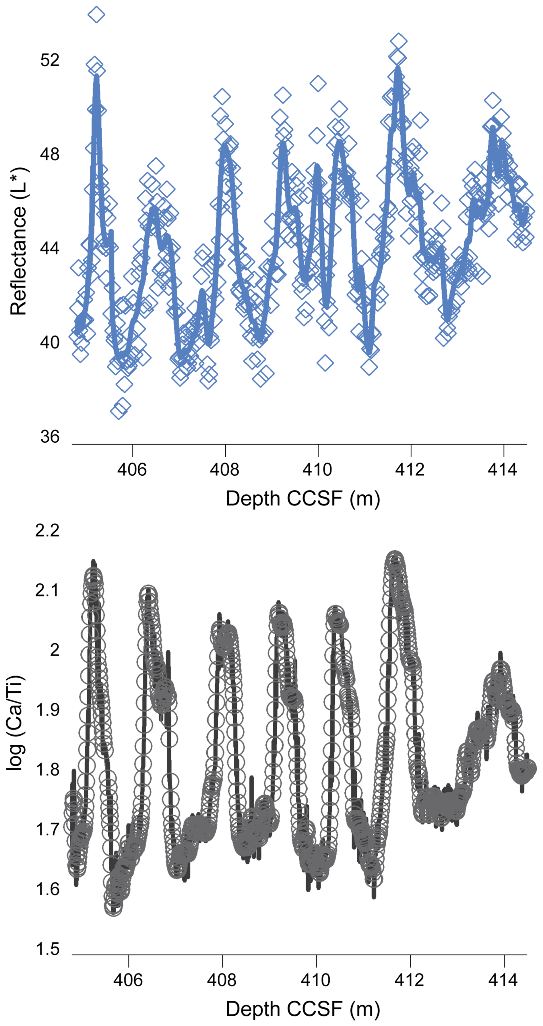
Figure 9Gaussian process modeling of two non-destructive measurements (XRF and color reflectance) of the same cored interval from Site U1587. Open symbols denote “raw” measurements, while the heavy lines show Gaussian process fits to the data (GPy Python library https://gpy.readthedocs.io/en/deploy/GPy.core.html, last access: 13 March 2026). Note that the dispersion of the measured L* parameter (color reflectance; a proxy for carbonate content) to the GP fit is greater than for the scanning XRF measurement of the log of calcium to titanium (which is also highly correlated to calcium carbonate) (from Alvarez Zarikian et al., 2026, under Creative Commons Attribution 4.0 International License https://creativecommons.org/licenses/by/4.0/, last access: 13 March 2026).
We will form a working group to advance new developments in signal alignment (see Sect. 4.2.2), building on existing methods for computer-assisted stratigraphic correlation and probabilistic alignment (Lisiecki and Lisiecki, 2002; Lisiecki and Herbert, 2007; Lin et al., 2014; Parrenin et al., 2015; Ahn et al., 2017; Muschitiello et al., 2020; Lee et al., 2023). We will adapt these and other advanced techniques and incorporate them into user-friendly software packages. Online tutorials will be developed to disseminate them to the scientific ocean drilling community and to train a new generation of early-career scientists in their use.
4.3.9 Computer vision and deep learning
SIGNALS will use deep-learning-based tools for processing line scanner core images to improve the signal-to-noise ratio and to calculate nominally undisturbed color reflectance records. Core images will be segmented using machine learning (Fazekas et al., 2017, 2023), which will automatically remove secondary color artifacts from images (i.e., different spots in the scanned image related to bioturbation, voids, drilling disturbance, iron oxides, and reduced sulfur minerals). The artifacts can make color data extremely noisy, which is why they need to be removed before further analysis. Manual removal of these imperfections is extremely time consuming, but the nature of the problem readily lends itself to automating the process using computer vision. Another issue is that the images must be precisely cropped to the curated lengths to calculate an accurate depth scale for the extracted color information. Otherwise, the color depth scale will drift away from other high-resolution data sets. It is impractical to manually do this for every core section applicable to this proposal. Thus, we used a combination of neural networks and computer vision to automate this task (Fazekas et al., 2023).
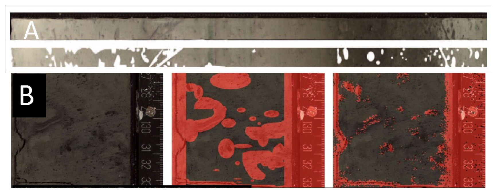
Figure 10(A) Identification of bioturbation features as part of a training set for automatic recognition using machine learning (Fazekas et al., 2017; Obrochta et al., 2020, 2022). (B) On the left is an image patch of a sediment core that was not included in the training data set but was (middle) manually masked. As shown on the right, the trained network was then used to successfully segment the image. Note that the manual masking is coarse due to the time required, but the segmentation result is finer and more precise.
The computer-vision-based method is currently available for download on GitHub (https://github.com/stephenobrochta/CoreAlign, last access: 13 March 2026). Convolutional neural networks require training and validation using images where artifacts have been manually identified (Fig. 10A). The IODP3 Expedition 506S Science Team will participate in producing these training data sets at the proposed study sites. Figure 10B shows segmentation results successfully identifying disturbed pixels in a sediment core (i.e., this image patch was not included in the training data but used to assess the validity of the segmentation). Once removed, the color data can be further cleaned using Gaussian process modeling as described above.
Computer vision is also applicable to identifying and counting particles in sediment coarse fraction. Counting IRD in sediment samples has been a mainstay of Quaternary paleoceanographic studies in the North Atlantic. Using AI models for image analysis and segmentation to automatically recognize and count IRD would add to the number of long IRD records available tremendously (e.g., Barker et al., 2021, 2022). The IODP3 Expedition 506S Science Team will produce training data sets and apply these automated methods to rapidly generate IRD records at several of the high-priority North Atlantic sites within and outside of the North Atlantic IRD belt. The records will also be used to test the reliability of using elemental ratios measured by XRF scanning as a proxy for IRD (Hodell et al., 2008).
Staffing of the IODP3 Expedition 506S Science Team involves a competitive process following an open call for participation published on the IODP3 website (https://iodp3.org, last access: 13 March 2026). Applications are evaluated by the Scientific Ocean Drilling Programme Member Offices, with staffing nominations taking into account both the scientific background of applicants; the scientific needs of the expedition; and programmatic national, gender, and career stage balances.
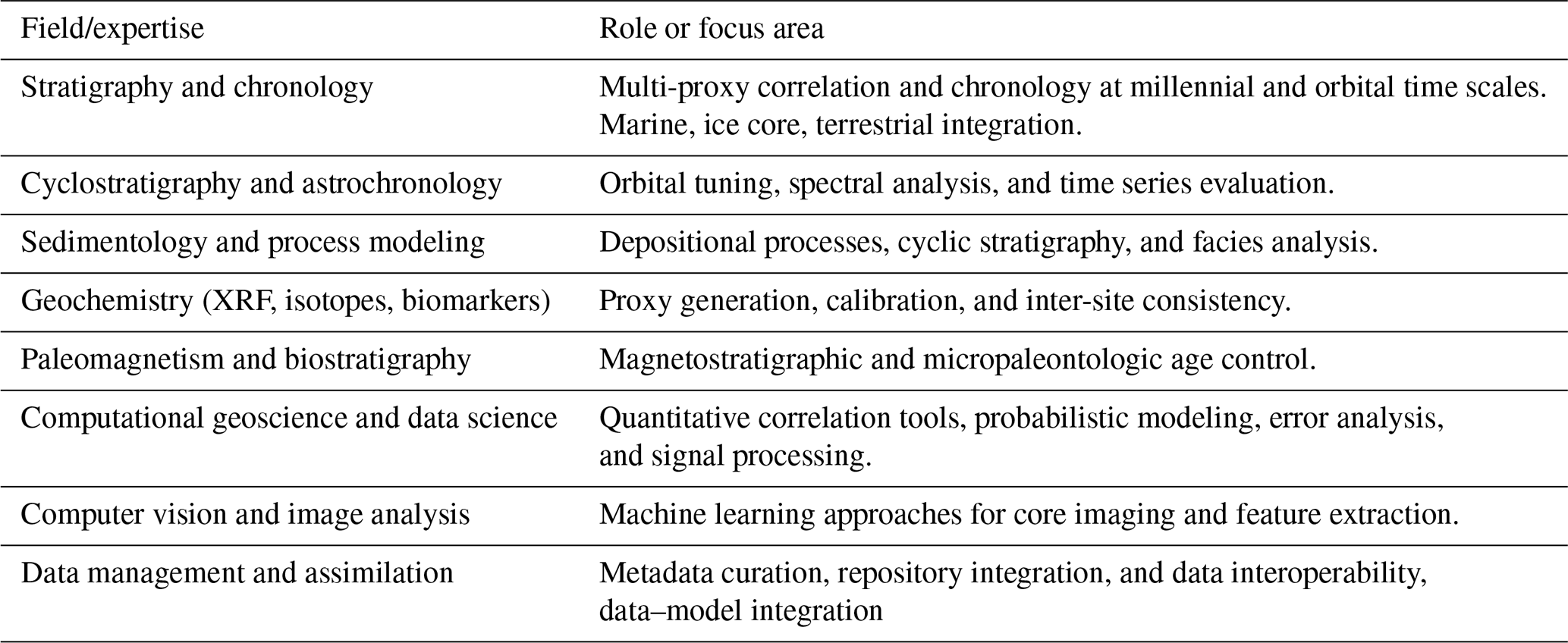
SIGNALS will bring together a multidisciplinary Science Team of researchers (Table 11). The team will include specialists spanning the full range of disciplines needed to correlate North Atlantic legacy sites across millennial and orbital timescales to create an integrated stratigraphic network. Each participant will be assigned to one or more working groups (see Sect. 4.2.2) according to expertise and interests, ensuring that both millennial and orbital correlation objectives are addressed collaboratively and coherently.
SIGNALS is committed to fostering an equitable, inclusive, and diverse research environment. Applications are welcomed from scientists of all backgrounds, career stages, and nationalities. Selection will reflect IODP3's principles of diversity, gender balance, early-career participation, and equitable access to scientific opportunities. Final staffing decisions will ensure a diverse, interdisciplinary, and balanced Science Team capable of delivering the integrated scientific objectives of the expedition. We strongly encourage applications from early-career researchers and those researchers who have worked on or still are working on the target sites listed in Table 1.
IODP3 Expedition 506S SIGNALS is the beginning of the scientific journeys outlined in this Prospectus. Staffing and meetings will be structured as much as possible to engage the next generation of scientists who may not have the opportunity to sail on a JOIDES Resolution-type vessel for some time and to catalyze multi-investigator studies that will take advantage of the stratigraphic syntheses proposed by SIGNALS using a new generation of proxy and modeling studies. Among the opportunities envisioned are “hackathons” and stratigraphic “boot camps” utilizing software and mathematical approaches developed over the course of the expedition. We aim to emulate the flow of data typical of shipboard participation and the potential for collaborations during and following SIGNALS. We will also use international meetings to highlight the work of SIGNALS and to entrain others in the community to the follow-up work that will be needed to fully accomplish the goals set by this expedition. Towards the end of the 3-year funded period, we plan to host a dedicated conference session at an international meeting (EGU, AGU) and/or a special topical conference to highlight the research outcomes of the expedition.
No data sets were used in this article.
DAH contributed to the conception and design of the expedition and drafted the prospectus. AS reviewed and edited the prospectus.
The contact author has declared that none of the authors has any competing interests.
Publisher's note: Copernicus Publications remains neutral with regard to jurisdictional claims made in the text, published maps, institutional affiliations, or any other geographical representation in this paper. The authors bear the ultimate responsibility for providing appropriate place names. Views expressed in the text are those of the authors and do not necessarily reflect the views of the publisher.
This SPARC Expedition will use legacy samples and data provided by the Deep Sea Drilling Project, Ocean Drilling Program, Integrated Ocean Drilling Program, International Ocean Discovery Program, and International Ocean Drilling Programme. SIGNALS began as an Ocean Drilling Legacy Assets Projects (LEAPs) proposal to IODP and evolved into a SPARC proposal of IODP3. We thank the proponents of the proposals and the scientific evaluation panels (SEPs) of both IODP and IODP3, who provided valuable feedback for shaping the SIGNALS project. In particular, we extend our sincere gratitude to Timothy Herbert, Stephen Obrochta, and Antje Voelker for their significant and invaluable contributions to the conception, design, and development of this expedition and prospectus. Finally, we thank Erin McClymont and Clara Bolton for their thoughtful reviews and suggestions that improved the quality of the prospectus.
This paper was edited by Simon George and reviewed by Clara Bolton and Erin McClymont.
Abrantes, F., Santos, C., Ventura, C., Voelker, A., and Röhl, U.: Data report: IODP Expedition 339 Site U1391: an improved splice and preliminary age model on the basis of XRF data, in: Proceedings of the Integrated Ocean Drilling Program, Volume 339, edited by: Stow, D. A. V., Hernández-Molina, F. J., Alvarez Zarikian, C. A., and the Expedition 339 Scientists, Integrated Ocean Drilling Program Management International, Inc., Tokyo, 1–5, https://doi.org/10.2204/iodp.proc.339.203.2017, 2017.
Ahn, S., Khider, D., Lisiecki, L., and Lawrence, C. E.: A probabilistic Pliocene-Pleistocene stack of benthic δ18O using a profile hidden Markov model, Dyn. Stat. Clim. Syst., 2, 1–16, https://doi.org/10.1093/climsys/dzx002, 2017.
Alvarez Zarikian, C. A., Herbert, T. D., Hodell, D. A., McManus, J. F., Nana-Yobo, L., Alonso-Garcia, M., Flores, J.-A., Huai-Hsuan, M., Haygood, L., Kars, M., Yeon, J., Abrantes, F., and the Expedition 397 Scientific Party: Data report: X-ray fluorescence core scanning of Pliocene–Pleistocene sediments from IODP Expedition 397 Site U1587, Iberian Margin, in: Proceedings of the International Ocean Discovery Program Volume 397, edited by: Hodell, D. A., Abrantes, F., Alvarez Zarikian, C. A., and the Expedition 397 Scientists, https://doi.org/10.14379/iodp.proc.397.203.2026, 2026.
Anderson, D. M.: Attenuation of millennial-scale events by bioturbation in marine sediments, Paleoceanography, 16, 352–357, https://doi.org/10.1029/2000PA000530, 2001.
Barker, S., Zhang, X., Jonkers, L., Lordsmith, S., Conn, S., and Knorr, G.: Strengthening Atlantic Inflow Across the Mid-Pleistocene Transition, Paleoceanogr. Paleocl., 36, e2020PA004200, https://doi.org/10.1029/2020PA004200, 2021.
Barker, S., Starr, A., van der Lubbe, J., Doughty, A., Knorr, G., Conn,S., Lordsmith, S., Owen, L., Nederbragt, A., Hemming, S., Hall, I., Levay, L., null null, Berke, M. A., Brentegani, L., Caley, T., Cartagena-Sierra, A., Charles, C. D., Coenen, J. J., Crespin, J. G., Franzese, A. M., Gruetzner, J., Han, X., Hines, S. K. V., Espejo, F. J. J., Just, J., Koutsodendris, A., Kubota, K., Lathika, N., Norris, R. D., dos Santos, T. P., Robinson, R., Rolison, J. M., Simon, M. H., Tangunan, D., Yamane, M., and Zhang, H.: Persistent influence of precession on northern ice sheet variability since the early Pleistocene, Science, 376, 961–967, https://doi.org/10.1126/science.abm4033, 2022.
Beaufort, L., Bolton, C. T., Sarr, A. C., Suchéras-Marx, B., Rosenthal, Y., Donnadieu, Y., Barbarin, N., Bova, S., Cornuault, P., Gally, Y., Gray, E., Mazur, J. C., and Tetard, M.: Cyclic evolution of phytoplankton forced by changes in tropical seasonality, Nature, 601, 79–84, https://doi.org/10.1038/s41586-021-04195-7, 2022.
Billups, K. and Scheinwald, A.: Origin of millennial-scale climate signals in the subtropical North Atlantic, Paleoceanography, 29, 612–627, https://doi.org/10.1002/2014PA002641, 2014.
Bolton, C. T., Wilson, P. A., Bailey, I., Friedrich, O., Beer, C. J., Becker, J., Baranwal, S., and Schiebel, R.: Millennial-scale climate variability in the subpolar North Atlantic Ocean during the late Pliocene, Paleoceanography, 25, PA4218, https://doi.org/10.1029/2010pa001951, 2010.
Bolton, C. T., Bailey, I., Friedrich, O., Tachikawa, K., de Garidel-Thoron, T., Vidal, L., Sonzogni, C., Marino, G., Rohling, E. J., Robinson, M. M., Ermini, M., Koch, M., Cooper, M. J., and Wilson, P. A.: North Atlantic Midlatitude Surface-Circulation Changes Through the Plio-Pleistocene Intensification of Northern Hemisphere Glaciation, Paleoceanogr. Paleocl., 33, 1186–1205, https://doi.org/10.1029/2018PA003412, 2018.
Bond, G., Heinrich, H., Broecker, W., Labeyrie, L., McManus, J., Andrews, J., Huon, S., Jantschik, R., Clasen, S., Simet, C., and Tedesco, K.: Evidence for massive discharges of icebergs into the North Atlantic Ocean during the last glacial period, Nature, 360, 245–249, https://doi.org/10.1038/360245a0, 1992.
Bond, G., Broecker, W., Johnsen, S., McManus, J., Labeyrie, L., Jouzel, J., and Bonani, G.: Correlations between climate records from North Atlantic sediments and Greenland ice, Nature, 365, 143–147, https://doi.org/10.1038/365143a0, 1993.
Broecker, W. S., Bond, G., Klas, M., Bonani, G., and Wolfli, W.: A salt oscillator in the glacial Atlantic? 1. The concept, Paleoceanography, 5, 469–477, https://doi.org/10.1029/PA005i004p00469, 1990.
Broecker, W. S., Bond, G., Klas, M., Clark, E., and McManus, J.: Origin of the North Atlantic Heinrich events, Clim. Dynam., 6, 265–273, https://doi.org/10.1007/BF00193540, 1992.
Catunda, M. C. A., Bahr, A., Kaboth-Bahr, S., Zhang, X., Foukal, N. P., and Friedrich, O.: Subsurface Heat Channel Drove Sea Surface Warming in the High-Latitude North Atlantic During the Mid-Pleistocene Transition, Geophys. Res. Lett., 48, https://doi.org/10.1029/2020GL091899, 2021.
Channell, J. E. T. and Hodell, D. A.: Magnetic signatures of Heinrich-like detrital layers in the Quaternary of the North Atlantic, Earth Planet. Sc. Lett., 369–370, 260–270, https://doi.org/10.1016/j.epsl.2013.03.034, 2013.
Channell, J. E. T., Sato, T., Kanamatsu, T., Stein, R., Malone, M., Alvarez-Zarikian, C., and the IODP Expeditions 303 and 306 Scientists: IODP Expeditions 303 and 306 Monitor Miocene- Quaternary Climate in the North Atlantic, Sci. Dril., 2, 4–10, https://doi.org/10.2204/iodp.sd.2.01.2006, 2006.
Channell, J. E. T., Hodell, D. A., and Curtis, J. H.: ODP Site 1063 (Bermuda Rise) revisited: Oxygen isotopes, excursions and paleointensity in the Brunhes Chron, Geochem. Geophy. Geosy., 13, Q02001, https://doi.org/10.1029/2011gc003897, 2012a.
Channell, J., Hodell, D., Romero, O., Hillaire-Marcel, C., de Vernal, A., Stoner, J., Mazaud, A., and Rohl, U.: A 750-kyr detrital-layer stratigraphy for the North Atlantic (IODP Sites U1302–U1303, Orphan Knoll, Labrador Sea), Earth Planet. Sc. Lett., 317–318, 218–230, https://doi.org/10.1016/j.epsl.2011.11.029, 2012b.
Chapman, M. R. and Shackleton, N. J.: What level of resolution is attainable in a deep-sea core? Results of a spectrophotometer study, Paleoceanography, 13, 311–315, https://doi.org/10.1029/98PA01067, 1998.
Crocker, A. J., Naafs, B. D. A., Westerhold, T., James, R. H., Cooper, M. J., Röhl, U., Pancost, R. D., Xuan, C., Osborne, C. P., Beerling, D. J., and Wilson, P. A.: Astronomically controlled aridity in the Sahara since at least 11 million years ago, Nat. Geosci., 15, 671–676, https://doi.org/10.1038/s41561-022-00990-7, 2022.
Dansgaard, W., Johnsen, S. J., Clausen, H. B., Dahl-Jensen, D., Gundestrup, N. S., Hammer, C. U., Hvidberg, C. S., Steffensen, J. P., Sveinbjörnsdottir, A. E., Jouzel, J., and Bond, G.: Evidence for general instability of past climate from a 250-kyr ice-core record, Nature, 364, 218–220, https://doi.org/10.1038/364218a0, 1993.
de Castro, S., Hernández-Molina, F. J., de Weger, W., Jiménez-Espejo, F. J., Rodríguez-Tovar, F. J., Mena, A., Llave, E., and Sierro, F. J.: Contourite characterization and its discrimination from other deep-water deposits in the Gulf of Cadiz contourite depositional system, Sedimentology, 68, 987–1027, https://doi.org/10.1111/sed.12813, 2021.
de Vleeschouwer, D., Dunlea, A. G., Auer, G., Anderson, C. H., Brumsack, H., de Loach, A., Gurnis, M., Huh, Y., Ishiwa, T., Jang, K., Kominz, M. A., März, C., Schnetger, B., Murray, R. W., Pälike, H., and Expedition 356 Shipboard Scientists: Quantifying K, U, and Th contents of marine sediments using shipboard natural gamma radiation spectra measured on DV JOIDES Resolution, Geochem. Geophy. Geosy., 18, 1053–1064, https://doi.org/10.1002/2016GC006715, 2017.
Driscoll, N. W. and Haug, G. H.: A short circuit in thermohaline circulation: A cause for Northern Hemisphere Glaciation?, Science, 282, 436–438, https://doi.org/10.1126/science.282.5388.436, 1998.
Drury, A. J., Westerhold, T., Hodell, D., and Röhl, U.: Reinforcing the North Atlantic backbone: revision and extension of the composite splice at ODP Site 982, Clim. Past, 14, 321–338, https://doi.org/10.5194/cp-14-321-2018, 2018.
Fazekas, S. Z., Obrochta, S. P., Sato, T., and Yamamura, Y.: Segmentation of coring images using fully convolutional neural networks, ICITEE, 9, 1–5, https://doi.org/10.1109/ICITEED.2017.8250490, 2017.
Fazekas, S. Z., Isawa, S., and Obrochta, S. P.: Automated extraction of sediment core and scale segments from core scanner images, ICITEE, 15, 1–6, https://doi.org/10.1109/ICITEE59582.2023.10317723, 2023.
Ferretti, P., Crowhurst, S. J., Naafs, B. D. A., and Barbante, C.: The Marine Isotope Stage 19 in the mid-latitude North Atlantic Ocean: astronomical signature and intra-interglacial variability, Quaternary Sci. Rev., 108, 95–110, https://doi.org/10.1016/j.quascirev.2014.10.024, 2015.
Flecker, R., Ducassou, E., Williams, T., and the Expedition 401 Scientists: Mediterranean–Atlantic Gateway Exchange. Proceedings of the International Ocean Discovery Program, 401: College Station, TX (International Ocean Discovery Program), https://doi.org/10.14379/iodp.proc.401.2025, 2025.
Flower, B. P., Oppo, D. W., McManus, J. F., Venz, K. A., Hodell, D. A., and Cullen, J.: North Atlantic intermediate to deep water circulation and chemical stratification during the past 1 Myr, Paleoceanography, 15, 388–403, https://doi.org/10.1029/1999PA000430, 2000.
Giosan, L., Flood, R. D., Grützner, J., and Mudie, P.: Paleoceanographic significance of sediment color on western North Atlantic Drifts: II. Late Pliocene-Pleistocene sedimentation, Mar. Geol., 189, 43–61, https://doi.org/10.1016/S0025-3227(02)00322-5, 2002.
González-Lanchas, A., Rickaby, R. E. M., Sierro, F. J., Rigual-Hernández, A. S., Alonso-García, M., and Flores, J.-A.: Globally enhanced calcification across the coccolithophore Gephyrocapsa complex during the mid-Brunhes interval, Quaternary Science Reviews, 108375, https://doi.org/10.1016/j.quascirev.2023.108375, 2023.
Grant, K. M., Amarathunga, U., Amies, J. D., Hu, P., Qian, Y., Penny, T., Rodriguez-Sanz, L., Zhao, X., Heslop, D., Liebrand, D., Hennekam, R., Westerhold, T., Gilmore, S., Lourens, L. J., Roberts, A. P., and Rohling, E. J.: Organic carbon burial in Mediterranean sapropels intensified during Green Sahara Periods since 3.2 Myr ago, Commun. Earth Environ., 3, 11, https://doi.org/10.1038/s43247-021-00339-9, 2022.
Grützner, J. and Higgins, S. M.: Threshold behavior of millennial scale variability in deep water hydrography inferred from a 1.1 Ma long record of sediment provenance at the southern Gardar Drift, Paleoceanography, 25, https://doi.org/10.1029/2009pa001873, 2010.
Grützner, J., Giosan, L., Franz, S. O., Tiedemann, R., Cortijo, E., Chaisson, W. P., Flood, R. D., Hagen, S., Keigwin, L. D., and Poli, S.: Astronomical age models for Pleistocene drift sediments from the western North Atlantic (ODP Sites 1055-1063), Mar. Geol., 189, 5–23, https://doi.org/10.1016/S0025-3227(02)00320-1, 2002.
Hagelberg, T. K., Bond, G., and deMenocal, P.: Milankovitch band forcing of sub-Milankovitch climate variability during the Pleistocene, Paleoceanography, 9, 545–558, https://doi.org/10.1029/94PA00443, 1994.
Haug, G. H. and Tiedemann, R.: Effect of the formation of the Isthmus of Panama on Atlantic Ocean thermohaline circulation, Nature, 393, 673–676, https://doi.org/10.1038/31447, 1998.
Heinrich, H.: Origin and consequences of cyclic ice rafting in the Northeast Atlantic Ocean during the past 130,000 years, Quaternary Res., 29, 142–152, https://doi.org/10.1016/0033-5894(88)90057-9, 1988.
Hemming, S. R.: Heinrich events: Massive late Pleistocene detritus layers of the North Atlantic and their global climate imprint, Rev. Geophys., 42, https://doi.org/10.1029/2003RG000128, 2004.
Herbert, T. D., Lawrence, K. T., Tzanova, A., Peterson, L. C., Caballero-Gill, R., and Kelly, C. S.: Late Miocene global cooling and the rise of modern ecosystems, Nature Geoscience, 9, 843–847, https://doi.org/10.1038/ngeo2813, 2016.
Hernández-Molina, F. J., Llave, E., Stow, D. A. V., García, M., Somoza, L., Vázquez, J. T., Lobo, F. J., Maestro, A., Díaz del Río, V., León, R., Medialdea, T., and Gardner, J.: The contourite depositional system of the Gulf of Cádiz: A sedimentary model related to the bottom current activity of the Mediterranean outflow water and its interaction with the continental margin, Deep-Sea Res. Pt. II, 53, 1420–1463, https://doi.org/10.1016/j.dsr2.2006.04.016, 2006.
Hernández-Molina, F. J., Stow, D. A. V., Alvarez-Zarikian, C. A., Acton, G., Bahr, A., Balestra, B., Ducassou, E., Flood, R., Flores, J.-A., Furota, S., Grunert, P., Hodell, D., Jimenez-Espejo, F., Kim, J. K., Krissek, L., Kuroda, J., Li, B., Llave, E., Lofi, J., Lourens, L., Miller, M., Nanayama, F., Nishida, N., Richter, C., Roque, C., Pereira, H., Sanchez Goñi, M. F., Sierro, F. J., Singh, A.D., Sloss, C., Takashimizu, Y., Tzanova, A., Voelker, A., Williams, T., and Xuan, C.: Onset of Mediterranean outflow into the North Atlantic, Science, 344, 1244–1250, https://doi.org/10.1126/science.1251306, 2014.
Hernández-Molina, F. J., Sierro, F. J., Llave, E., Roque, C., Stow, D. A. V., Williams, T., Lofi, J., Van der Schee, M., Arnáiz, A., Ledesma, S., Rosales, C., Rodríguez-Tovar, F. J., Pardo-Igúzquiza, E., and Brackenridge, R. E.: Evolution of the Gulf of Cadiz margin and southwest Portugal contourite depositional system: Tectonic, sedimentary and paleoceanographic implications from IODP expedition 339, Mar. Geol., 377, 7–39, https://doi.org/10.1016/j.margeo.2015.09.013, 2016.
Hilgen, F. J.: Astronomical Calibration of Gauss to Matuyama Sapropels in the Mediterranean and Implication for the Geomagnetic Polarity Time Scale, Earth Planet. Sc. Lett., 104, 226–244, https://doi.org/10.1016/0012-821X(91)90206-W, 1991.
Hilgen, F.: Revised astrochronology for the Lower to Middle Miocene of IODP site U1337. Implications for the Cenozoic megasplice (CENOGRID), Palaeogeogr. Palaeocl., 662, 112748, https://doi.org/10.1016/j.palaeo.2025.112748, 2025.
Hodell, D. A., Channell, J. E. T., Curtis, J. H., Romero, O. E., and Rohl, U.: Onset of “Hudson Strait” Heinrich events in the eastern North Atlantic at the end of the middle Pleistocene transition (640 ka)?, Paleoceanography, 23, https://doi.org/10.1029/2008PA001591, 2008.
Hodell, D., Lourens, L., Crowhurst, S., Konijnendijk, T., Tjallingii, R., Jiménez-Espejo, F., Skinner, L., Tzedakis, P. C., Abrantes, F., Acton, G. D., Alvarez Zarikian, C. A., Bahr, A., Balestra, B., Barranco, E. L., Carrara, G., Ducassou, E., Flood, R. D., Flores, J.-A., Furota, S., Grimalt, J., Grunert, P., Hernández-Molina, J., Kim, J. K., Krissek, L. A., Kuroda, J., Li, B., Lofi, J., Margari, V., Martrat, B., Miller, M. D., Nanayama, F., Nishida, N., Richter, C., Rodrigues, T., Rodríguez-Tovar, F. J., Roque, A. C. F., Sanchez Goñi, M. F., Sierro Sánchez, F. J., Singh, A. D., Sloss, C. R., Stow, D. A. V., Takashimizu, Y., Tzanova, A., Voelker, A., Xuan, C., and Williams, T.: A reference time scale for Site U1385 (Shackleton Site) on the SW Iberian Margin, Global Planet. Change, 133, 49–64, https://doi.org/10.1016/j.gloplacha.2015.07.002, 2015.
Hodell, D. A., Crowhurst, S. J., Lourens, L., Margari, V., Nicolson, J., Rolfe, J. E., Skinner, L. C., Thomas, N. C., Tzedakis, P. C., Mleneck-Vautravers, M. J., and Wolff, E. W.: A 1.5-million-year record of orbital and millennial climate variability in the North Atlantic, Clim. Past, 19, 607–636, https://doi.org/10.5194/cp-19-607-2023, 2023.
Hodell, D. A., Abrantes, F., Alvarez Zarikian, C. A., Brooks, H. L., Clark, W. B., Dauchy-Tric, L. F. B., dos Santos Rocha, V., Flores, J.-A., Herbert, T. D., Hines, S. K. V., Huang, H.-H. M., Ikeda, H., Kaboth-Bahr, S., Kuroda, J., Link, J. M., McManus, J. F., Mitsunaga, B. A., Nana Yobo, L., Pallone, C. T., Pang, X., Peral, M. Y., Salgueiro, E., Sanchez, S., Verma, K., Wu, J., Xuan, C., and Yu, J.: Expedition 397 summary, in: Iberian Margin Paleoclimate, edited by: Hodell, D. A., Abrantes, F., Alvarez Zarikian, C. A., and the Expedition 397 Scientists, Proceedings of the International Ocean Discovery Program, 397, College Station, TX (International Ocean Discovery Program), https://doi.org/10.14379/iodp.proc.397.101.2024, 2024.
Hodell, D. A., Abrantes, F., Alvarez Zarikian, C. A., Herbert, T. D., Du, M., Crowhurst, S. J., Mleneck-Vautravers, M., Rolfe, J. E., Chen, X., Brooks, H. L., Clark, W. B., Dauchy-Tric, L. F. B., dos Santos Rocha, V., Flores, J.-A., Hines, S. K. V., Huang, H.-H. M., Ikeda, H., Kaboth-Bahr, S., Kuroda, J., Link, J. M., McManus, J. F., Mitsunaga, B. A., Yobo, L. N., Pallone, C. T., Pang, X., Péral, M. Y., Salgueiro, E., Sanchez, S., Verma, K., Wu, J., Xuan, C., Yu, J., Haygood, L. A., Liebrand, D., Magalhães, V., Alonso-Garcia, M., Duque-Castaño, M., Ferreira, F., Freitas, M., Cordeiro, L. G., Gil, I., González-Martín, M., Lopes, A., Lopes, C., Margari, V., Martín-García, L., Matos, L., Mega, A., Molina, G., Naughton, F., Oliveira, D., Rebotim, A., Rodrigues, T., Santana, A., Trejos-Tamayo, R., and Tzedakis, P. C.: Onset of glacial millennial climate variability with the Intensification of Northern Hemisphere glaciation, Science, https://doi.org/10.1126/science.ady7970, 2026a.
Hodell, D. A., Crowhurst, S. C., Vautravers, M. J., Rolfe, J. A., Du, M., Herbert, T. D., Huang, H.-H. M., Abrantes, F., Alvarez Zarikian, C. A., and the Expedition 397 Scientists: Data Report: Revised Composite Section and Chronology of Site 339-U1385 and 397-U1385 based on Postcruise XRF Analysis, in: Proceedings of the International Ocean Discovery Program Volume 397, edited by: Hodell, D. A., Abrantes, F., Alvarez Zarikian, C. A., and the Expedition 397 Scientists, https://doi.org/10.14379/iodp.proc.397.204.2026, 2026b.
Hülse, D., Vervoort, P., van de Velde, S. J., Kanzaki, Y., Boudreau, B., Arndt, S., Bottjer, D. J., Hoogakker, B., Kuderer, M., Middelburg, J. J., Volkenborn, N., Kirtland Turner, S., and Ridgwell, A.: Assessing the impact of bioturbation on sedimentary isotopic records through numerical models, Earth Sci. Rev., 234, 104213, https://doi.org/10.1016/j.earscirev.2022.104213, 2022.
Kaboth-Bahr, S., Bahr, A., Stepanek, C., Catunda, M. C. A., Karas, C., Ziegler, M., García-Gallardo, Á., and Grunert, P.: Mediterranean heat injection to the North Atlantic delayed the intensification of Northern Hemisphere glaciations, Commun. Earth Environ., 2, 158, doi.org:10.1038/s43247-021-00232-5, 2021.
Kaiser, E. A., Caldwell, A., and Billups, K.: North Atlantic Upper-Ocean Hydrography During the Mid-Pleistocene Transition Evidenced by Globorotalia truncatulinoides Coiling Ratios, Paleoceanogr. Paleocl., 34, 658–671, https://doi.org/10.1029/2018PA003502, 2019.
Keigwin, L. D., Rio, D., Acton, G. D., Bianchi, G. G., Borowski, W., Çagatay, N., Chaisson, W. P., Clement, B. M., Cortijo, E., Dunbar, G. B., Flood, R. D., Franz, S.-O., Giosan, L., Grützner, J., Hagen, S., Haskell, B., Horowitz, M. J., Laine, E. P., Lund, S. P., Okada, M., Poli, M.-S., Raffi, I., Reuer, M. K., Ternois, Y. G., Williams, T., Winter, D. M., and Yokokawa, M. E.: Proceedings of the Ocean Drilling Program Initial Reports Volume 172, College Station, TX (Ocean Drilling Program), https://doi.org/10.2973/odp.proc.ir.172.1998, 1998.
Kleiven, H. F., Jansen, E., Curry, W. B., Hodell, D. A., and Venz, K.: Atlantic Ocean thermohaline circulation changes on orbital to suborbital timescales during the mid-Pleistocene, Paleoceanography, 18, https://doi.org/10.1029/2001PA000629, 2003.
Lawrence, K. T., Sigman, D. M., Herbert, T. D., Riihimaki, C. A., Bolton, C. T., Martinez-Garcia, A., Rosell-Mele, A., and Haug, G. H.: Time-transgressive North Atlantic productivity changes upon Northern Hemisphere glaciation, Paleoceanography, 28, 2013PA002546, https://doi.org/10.1002/2013PA002546, 2013.
Lee, T., Rand, D., Lisiecki, L. E., Gebbie, G., and Lawrence, C.: Bayesian age models and stacks: combining age inferences from radiocarbon and benthic δ18O stratigraphic alignment, Clim. Past, 19, 1993–2012, https://doi.org/10.5194/cp-19-1993-2023, 2023.
Liautaud, P. R., Hodell, D. A., and Huybers, P. J.: Detection of significant climatic precession variability in early Pleistocene glacial cycles, Earth Planet. Sc. Lett., 536, 116–137, https://doi.org/10.1016/j.epsl.2020.116137, 2020.
Liebrand, D. and de Bakker, A. T. M.: Bispectra of climate cycles show how ice ages are fuelled, Clim. Past, 15, 1959–1983, https://doi.org/10.5194/cp-15-1959-2019, 2019.
Liebrand, D., de Bakker, A. T. M., Johnstone, H. J. H., and Miller, C. S.: Disparate energy sources for slow and fast Dansgaard–Oeschger cycles, Clim. Past, 19, 1447–1459, https://doi.org/10.5194/cp-19-1447-2023, 2023.
Lin, L., Khider, D., Lisiecki, L. E., and Lawrence, C. E.: Probabilistic sequence alignment of stratigraphic records, Paleoceanography, 29, 976–989, https://doi.org/10.1002/2014PA002713, 2014.
Lisiecki, L. E. and Herbert, T. D.: Automated composite depth scale construction and estimates of sediment core extension, Paleoceanography, 22, https://doi.org/10.1029/2006PA001401, 2007.
Lisiecki, L. E. and Lisiecki, P. A.: Application of dynamic programming to the correlation of paleoclimate records, Paleoceanography, 17, 1049, https://doi.org/10.1029/2001PA000733, 2002.
Lisiecki, L. E. and Raymo, M. E.: A Pliocene-Pleistocene stack of 57 globally distributed benthic δ18O records, Paleoceanography, 20, https://doi.org/10.1029/2004PA001071, 2005.
Lofi, J., Voelker, A. H. L., Ducassou, E., Hernández-Molina, F. J., Sierro, F. J., Bahr, A., Galvani, A., Lourens, L. J., Pardo-Igúzquiza, E., Pezard, P., Rodríguez-Tovar, F. J., and Williams, T.: Quaternary chronostratigraphic framework and sedimentary processes for the Gulf of Cadiz and Portuguese Contourite Depositional Systems derived from natural gamma ray records, Mar. Geol., 377, 40–57, https://doi.org/10.1016/j.margeo.2015.12.005, 2016.
Lozier, M. S. and Stewart, N. M.: On the Temporally Varying Northward Penetration of Mediterranean Overflow Water and Eastward Penetration of Labrador Sea Water, J. Phys. Oceanogr., 38, 2097–2103, https://doi.org/10.1175/2008JPO3908.1, 2008.
McClymont, E. L., Ho, S. J., Ford, H. L., Bailey, I., Berke, M. A., Bolton, C. T., De Schepper, S., Grant, G. R., Groeneveld, J., Inglis, G. N., Karas, C., Patterson, M. O., Swann, G. E. A., Thirumalai, K., White, S. M., Alonso-Garcia, M., Anand, P., Hoogakker, B. A. A., Littler, K., Petrick, B. F., Risebrobakken, B., Abell, J. T., Crocker, A. J., de Graaf, F., Feakins, S. J., Hargreaves, J. C., Jones, C. L., Markowska, M., Ratnayke, A. S., Stepanek, C., and Tangunun, D.: Climate evolution through the onset and intensification of Northern Hemisphere Glaciation, Rev. Geophys., 61, e2022RG000793, https://doi.org/10.1029/2022RG000793, 2023.
McIntyre, A., Ruddiman, W. F., Karlin, K., and Mix, A. C.: Surface water response of the equatorial Atlantic Ocean to orbital forcing, Paleoceanography, 4, 19–55, https://doi.org/10.1029/PA004i001p00019, 1989.
McManus, J. F., Oppo, D. W., and Cullen, J. L.: A 0.5 million year record of millennial-scale climate variability in the North Atlantic, Science, 283, 971–975, https://doi.org/10.1126/science.283.5404.971, 1999.
Meyers, S. R.: Cyclostratigraphy and the problem of astrochronologic testing, Earth Sci. Rev., 190, 190–223, https://doi.org/10.1016/j.earscirev.2018.11.015, 2019.
Muschitiello, F. and Aquino-Lopez, M. A.: Continuous synchronization of the Greenland ice-core and U–Th timescales using probabilistic inversion, Clim. Past, 20, 1415–1435, https://doi.org/10.5194/cp-20-1415-2024, 2024.
Muschitiello, F., O'Regan, M., Martens, J., West, G., Gustafsson, Ö., and Jakobsson, M.: A new 30 000-year chronology for rapidly deposited sediments on the Lomonosov Ridge using bulk radiocarbon dating and probabilistic stratigraphic alignment, Geochronology, 2, 81–91, https://doi.org/10.5194/gchron-2-81-2020, 2020.
Naafs, B. D. A., Hefter, J., and Stein, R.: Millennial-scale ice rafting events and Hudson Strait Heinrich(-like) Events during the late Pliocene and Pleistocene: A review, Quaternary Sci. Rev., 80, 1–28, https://doi.org/10.1016/j.quascirev.2013.08.014, 2013.
Naafs, B. D. A., Voelker, A. H. L., Karas, C., Andersen, N., and Sierro, F. J.: Repeated Near-Collapse of the Pliocene Sea Surface Temperature Gradient in the North Atlantic, Paleoceanogr. Paleocl., 35, https://doi.org/10.1029/2020PA003905, 2020.
Obrochta, S. P., Crowley, T. J., Channell J. E. T., Hodell, D. A., Baker P. A., Seki, A., and Yokoyama, Y.: Climate variability and ice-sheet dynamics during the last three glaciations, Earth Planet. Sc. Lett., 406, 198–212, https://doi.org/10.1016/j.epsl.2014.09.004, 2014.
Obrochta, S., Fazekas, S., and Morén, J.: Using computer vision and deep learning for acquisition and processing of low-distortion sediment core images, EGU General Assembly 2020, Online, 4–8 May 2020, EGU2020-20954, https://doi.org/10.5194/egusphere-egu2020-20954, 2020.
Obrochta, S. P., Fazekas, S. Z., and Morén, J.: Acquisition and processing of low-distortion sediment core images with computer vision and deep learning, AGU Fall Meeting 2022, Chicago, 12–16 December 2022, https://agu.confex.com/agu/fm22/meetingapp.cgi/Paper/1140373 (last access: 17 March 2026), 2022.
O'Dea, A., Lessios, H. A., Coates, A. G., Eytan, R. I., Restrepo-Moreno, S. A., Cione, A. L., Collins, L. S., de Queiroz, A., Farris, D. W., Norris, R. D., Stallard, R. F., Woodburne, M. O., Aguilera, O., Aubry, M.-P., Berggren, W. A., Budd, A. F., Cozzuol, M. A., Coppard, S. E., Duque-Caro, H., Finnegan, S., Gasparini, G. M., Grossman, E. L., Johnson, K. G., Keigwin, L. D., Knowlton, N., Leigh, E. G., Leonard-Pingel, J. S., Marko, P. B., Pyenson, N. D., Rachello-Dolmen, P. G., Soibelzon, E., Soibelzon, L., Todd, J. A., Vermeij, G. J., and Jackson, J. B. C.: Formation of the Isthmus of Panama, Sci. Adv., 2, e1600883, https://doi.org/10.1126/sciadv.1600883, 2016.
Öğretmen, N., Schiebel, R., Jochum, K. P., Stoll, B., Weis, U., Repschläger, J., Jentzen, A., Galer, S., and Haug, G. H.: Deep thermohaline circulation across the closure of the Central American Seaway, Paleoceanogr. Paleocl., 35, e2020PA004049, https://doi.org/10.1029/2020PA004049, 2020.
Otto-Bliesner, B. L., Jahn, A., Feng, R., Brady, E. C., Hu, A., and Löfverström, M.: Ampli?ed North Atlantic warming in the late Pliocene by changes in Arctic gateways, Geophys. Res. Lett., 44, 957–964, https://doi.org/10.1002/2016GL071805, 2017.
Parnell-Turner, R., White, N. J., McCave, I. N., Henstock, T. J., Murton, B., and Jones, S. M.: Architecture of North Atlantic contourite drifts modified by transient circulation of the Icelandic mantle plume, Geochem. Geophy. Geosy., 16, 3414–3435, https://doi.org/10.1002/2015GC005947, 2015.
Parnell-Turner, R. E., Briais, A., LeVay, L. J., and the Expedition 395 Scientists: Reykjanes Mantle Convection and Climate, Proceedings of the International Ocean Discovery Program, 395, https://doi.org/10.14379/iodp.proc.395.2025, 2025.
Parrenin, F., Bazin, L., Capron, E., Landais, A., Lemieux-Dudon, B., and Masson-Delmotte, V.: IceChrono1: a probabilistic model to compute a common and optimal chronology for several ice cores, Geosci. Model Dev., 8, 1473–1492, https://doi.org/10.5194/gmd-8-1473-2015, 2015.
Rasmussen, C. E. and Williams, C. K. I.: Gaussian Processes for Machine Learning, MIT Press, ISBN 026218253X, 2006.
Raymo, M. E.: Appendix. New insights into Earth's history: an introduction to Leg 162 postcruise research published in journals, in: Proc. ODP, Sci. Results, edited by: Raymo, M. E., Jansen, E., Blum, P., and Herbert, T. D., 162: College Station, TX (Ocean Drilling Program), 273–275, https://doi.org/10.2973/odp.proc.sr.162.039.1999, 1999.
Raymo, M. E., Ruddiman, W. F., Backman, J., Clement, B. M., and Martinson, D. G.: Late Pliocene variation in northern hemisphere ice sheets and North Atlantic deep water circulation, Paleoceanography, 4, 413–446, https://doi.org/10.1029/PA004i004p00413, 1989.
Raymo, M., Ganley, K., Carter, S., Oppo, D. W., and McManus, J.: Millennial-scale climate instability during the early Pleistocene epoch, Nature, 392, 699–702, https://doi.org/10.1038/33658, 1998.
Robinson, M. M., Valdes, P. J., Haywood, A. M., Dowsett, H. J., Hill, D. J., and Jones, S. M.: Bathymetric controls on Pliocene North Atlantic and Arctic sea surface temperature and deepwater production, Palaeogeogr. Palaeocl., 309, 92–97, https://doi.org/10.1016/j.palaeo.2011.01.004, 2011.
Ruddiman, W. F.: Late Quaternary deposition of ice-rafted sand in the subpolar North Atlantic (lat 40° to 65° N), Geol. Soc. Am. Bull., 88, 1813–1827, https://doi.org/10.1130/0016-7606(1977)88<1813:LQDOIS>2.0.CO;2, 1977.
Ruddiman, W. F., Raymo, M., and McIntyre, A.: Matuyama 41,000-year cycles: North Atlantic Ocean and northern hemisphere ice sheets, Earth Planet. Sc. Lett., 80, 117–129, https://doi.org/10.1016/0012-821X(86)90024-5, 1986.
Ruddiman, W. F., Cameron, D., and Clement, B. M.: Sediment Disturbance and Correlation of Offset Holes Drilled with the Hydraulic Piston Corer: Leg 94, Initial Rep. Deep Sea Drill. Proj., 94, 615–674, https://doi.org/10.2973/dsdp.proc.94.111.1987, 1987
Ruddiman, W. F., Raymo, M. E., Lamb, H. H., and Andrews, J. T.: Northern Hemisphere climate régimes during the past 3 Ma: possible tectonic connections, Philos. T. Roy. Soc. B, 318, 411-430, https://doi.org/10.1098/rstb.1988.0017, 1988.
Ruddiman, W. F., Raymo, M. E., Martinson, D. G., Clement, B. M., and Backman, J.: Pleistocene evolution: Northern hemisphere ice sheets and North Atlantic Ocean, Paleoceanography, 4, 353–412, https://doi.org/10.1029/PA004i004p00353, 1989.
Shackleton, N., Berger, A., and Peltier, W.: An alternative astronomical calibration of the lower Pleistocene timescale based on ODP Site 677, T. RSE Earth, 81, 251–261, https://doi.org/10.1017/S0263593300020782, 1990.
Shackleton, N. J., Hall, M. A., and Vincent, E.: Phase relationships between millennial-scale events 64,000–24,000 years ago, Paleoceanography, 15, 565–569, https://doi.org/10.1029/2000PA000513, 2000.
Shackleton, N. J., Fairbanks, R. G., Chiu, T.-C., and Parrenin, F.: Absolute calibration of the Greenland time scale: implications for Antarctic time scales and for Δ14C, Quaternary Sci. Rev., 23, 1513–1522, https://doi.org/10.1016/j.quascirev.2004.03.006, 2004.
Sinnesael, M., Karatsolis, B.-T., Pearson, P. N., Briais, A., Hemming, S. R., LeVay, L. J., Dunkley Jones, T., Cui, Y., Di Chiara, A., Dodd, J. P., Dwyer, D., Eason, D. E., Friedman, S. A., Hanson, E., Hochmuth, K., Ibrahim, H. E., Jasper, C. E., Lee-Takeda, S., LeBlanc, D. E., Lindsay, M. R., McNamara, D. D., Modestou, S. E., Morris, M. A., Murton, B. J., Oconnell, S., Pasquet, G., Qian, S.-P., Rosenthal, Y., Satolli, S., Suzuki, T., Thulasi, T., Wade, B. S., White, N. J., Wu, T., Yang, A. Y., and Parnell-Turner, R. E.: Onset of strong Iceland-Scotland overflow water 3.6 million years ago, Nat. Commun., 16, 4323, https://doi.org/10.1038/s41467-025-59265-5, 2025.
Stow, D. A. V., Hernández-Molina, F. J., Alvarez Zarikian, C. A., and the Expedition 339 Scientists: Proceedings of the Integrated Ocean Drilling Program, Volume 339, Tokyo (Integrated Ocean Drilling Program Management International, Inc.), https://doi.org/10.2204/iodp.proc.339.2013, 2013.
Thunell, R. C., Poli, M. S., and Rio, D.: Changes in deep and intermediate water properties in the western North Atlantic during marine isotope stages 11-12: evidence from ODP Leg 172, Mar. Geol., 189, 63–77, https://doi.org/10.1016/S0025-3227(02)00323-7, 2002.
Trauth, M. H.: TURBO2: A MATLAB simulation to study the effects of bioturbation on paleoceanographic time series, Comput. Geosci., 61, 1–10, https://doi.org/10.1016/j.cageo.2013.05.003, 2013.
Voelker, A. H. L., Rodrigues, T., Billups, K., Oppo, D., McManus, J., Stein, R., Hefter, J., and Grimalt, J. O.: Variations in mid-latitude North Atlantic surface water properties during the mid-Brunhes (MIS 9–14) and their implications for the thermohaline circulation, Clim. Past, 6, 531–552, https://doi.org/10.5194/cp-6-531-2010, 2010.
Voelker, A. H. L., Jimenez-Espejo, F. J., Bahr, A., Rebotim, A., Cavaleiro, C., Salgueiro, E., and Röhl, U.: Data report: IODP Site U1387: the revised splice between Sections U1387B-18X-3 and U1387C-8R-3 (>171.6 mcd), in: Proceedings of the Integrated Ocean Drilling Program, Volume 339, edited by: Stow, D. A. V., Hernández-Molina, F. J., Alvarez Zarikian, C. A., and the Expedition 339 Scientists, Integrated Ocean Drilling Program Management International, Inc., Tokyo, 1–11, https://doi.org/10.2204/iodp.proc.339.204.2018, 2018.
WAIS Divide Project Members: Precise interpolar phasing of abrupt climate change during the last ice age, Nature, 520, 661–665, https://doi.org/10.1038/nature14401, 2015.
Weirauch, D., Billups, K., and Martin, P.: Evolution of millennial-scale climate variability during the Mid Pleistocene, Paleoceanogr., 23, https://doi.org/10.1029/2007PA001584, 2008.
Westerhold, T., Marwan, N., Drury, A. J., Liebrand, D., Agnini, C., Anagnostou, E., Barnet, J. S. K., Bohaty, S. M., De Vleeschouwer, D., Florindo, F., Frederichs, T., Hodell, D. A., Holbourn, A. E., Kroon, D., Lauretano, V., Littler, K., Lourens, L. J., Lyle, M., Pälike, H., Röhl, U., Tian, J., Wilkens, R. H., Wilson, P. A., and Zachos, J. C.: An astronomically dated record of Earth's climate and its predictability over the last 66 million years, Science, 369, 1383–1387, https://doi.org/10.1126/science.aba6853, 2020.
Westerhold, T., Agnini, C., Anagnostou, E., Hilgen, F., Hönisch, B., Meckler, A. N., Pälike, H., Wade, B., Sosdian, S., and Kasbohm, J.: Timing is everything, Paleoceanogr. Paleocl., 39, e2024PA004932, https://doi.org/10.1029/2024PA004932, 2024.
Wilkens, R. H., Westerhold, T., Drury, A. J., Lyle, M., Gorgas, T., and Tian, J.: Revisiting the Ceara Rise, equatorial Atlantic Ocean: isotope stratigraphy of ODP Leg 154 from 0 to 5 Ma, Clim. Past, 13, 779–793, https://doi.org/10.5194/cp-13-779-2017, 2017.
Zeeden, C., Obreht, I., Veres, D., Kaboth-Bahr, S., Hošek, J., Marković, S. B., Bösken, J., Lehmkuhl, F., Rolf, C., and Hambach, U.: Smoothed millennial-scale palaeoclimatic reference data as unconventional comparison targets: Application to European loess records, Sci. Rep., 10, 5455, https://doi.org/10.1038/s41598-020-61528-8, 2020.