
the Creative Commons Attribution 4.0 License.
the Creative Commons Attribution 4.0 License.
 | 01 Sep 2026
IODP3 Expedition 507 “Late Cenozoic Glaciers, LAndscapes, Climates, and Ecosystems of the North Sea (GLACE-NS)” Scientific Prospectus

Freek S. Busschers
Ulysses S. Ninnemann
Margaret A. Stewart
Intensification of glacial–interglacial cycles at the Pleistocene onset (∼ 2.6 Ma) was a critical transition in Earth's climate history. The increased severity of cold conditions triggered the development of continental-scale ice sheets, which then affected the global climate system through complex ocean–atmosphere–cryosphere linkages. Besides estimates of global ice volume with poor spatio-temporal control, little is known about late Plio-Pleistocene ice sheet fluctuations during the transition from late Pliocene warmth to intensified Pleistocene glaciations, or the apparent change to greater ice volumes during the Middle Pleistocene Transition (∼ 1.2–0.8 Ma). Our inability to reconstruct the extent of ice sheets through these major climate shifts limits our understanding of the causes of long-term climate change and the ways in which ice sheet feedback loops influence environmental change. The North Sea Basin (NSB) contains a ∼ 1.2 km thick marine record of the late Plio-Pleistocene that, unlike the land-based record, preserves an almost complete archive of erosion and deposition by Europe's ice sheets and large river systems. Thus, the sequence preserved in the NSB is a significant palaeoclimate archive of late Plio-Pleistocene climate–environmental linkages. While the NSB is extensively covered by industry data, the late Plio-Pleistocene interval lacks samples providing geological control on existing palaeoclimate interpretations. The International Ocean Drilling Programme (IODP3) Expedition 507 will unravel how glaciers, landscapes, climate, and ecosystems evolved and interacted through the late Plio-Pleistocene. The expedition will contribute knowledge on natural climate variability, analogues of past warmer climates, tipping points, and rates of change. The mid-latitude location of the NSB allows for linkages between low- and high-latitude records, and potential feedbacks and teleconnections of north-west European climate with other parts of the climate system – e.g. European ice sheet influence on North Atlantic storm tracks. A particular focus on ecosystem evolution will reveal climate- and biology-related feedbacks, resilience, recovery, and carbon cycle dynamics. The results will tie into the 2050 Science Framework through Strategic Objectives 3–5 and Flagship Initiative 1 (ground-truthing future climate change) and will contribute to better calibration of numerical Earth-system models, knowledge on climate sensitivity and variability, and a wider appreciation of feedbacks within the Earth system.
- Article
(9791 KB) - Full-text XML
- BibTeX
- EndNote


IODP3 Expedition 507 is provisionally scheduled to take place in spring 2027, with the final drill site to be determined based on scientific objectives, the type of vessel used, and permitting (as of April 2026). The tendering process for a suitable vessel is ongoing, and the expedition will use either a geotechnical-type vessel or a liftboat/jackup rig.
Intensification of global glacial–interglacial cycles, marked by the onset of the Pleistocene (∼ 2.6 Ma), was a critical climate transition as increasingly severe cold conditions triggered continental-scale Northern Hemisphere glaciation. While the last glacial cycle (peaking at ∼ 25–21 ka) is increasingly well-understood, the nature of prior glaciations remains less comprehensive, with little information about ice sheet margins, the underlying glacial- and morpho-dynamic controls, and how glacial variability was linked with climate and ecosystem changes. There is piecemeal evidence for some of these unknowns – e.g. landforms on the glaciated terrains of north-west Europe and North America suggest that, in some instances, Early Pleistocene ice sheets may have been comparable in size to those in the Late Pleistocene (Balco and Rovey, 2010; Rea et al., 2018). However, with Early Pleistocene sea level lowstand estimates generally, but not always, ∼ 50 %–60 % of those in the Late Pleistocene (Miller et al., 2011; Jakob et al., 2020), such observations provide uncertainty as to how they match up and, more broadly, the nature of Pleistocene climate–cryosphere evolution and its feedbacks relative to the preceding Pliocene global warmth. If we cannot fully understand the nuances of such discrepancies, then it provides a limit on how effectively the past can be used as an analogue for the future.
The ∼ 600 km long North Sea Basin (NSB) transitioned through ∼ 50 glacial–interglacial cycles – of varying lengths between the worlds dominated by the 41 and 100 kyr cycles (Fig. 1) – as it was infilled by an offset-stacked succession of largely muddy deep-to-shallow marine and terrestrial sediments (Lamb et al., 2018). Ample accommodation and high sediment fluxes combined to preserve a unique ∼ 1.2 km thick late Plio-Pleistocene succession that captures the co-evolution of glaciation and Europe's largest river systems in a shallow marine basin (Gibbard, 1988; Rea et al., 2018). Importantly, the depocentre architecture indicates that northward progradation between 3.3 and 1.7 Ma is recorded within dominantly muddy, high-sedimentation-rate (> 0.6 m kyr−1) deposits in the central and southern NSB, while younger muddy sequences from 1.7 to 0.5 Ma in the northern basin preserve the record at similarly high resolution (>0.5 m kyr−1). The 0.5 Ma–Holocene sequence is 250–300 m thick in both areas, yielding ice proximal and distal records of overlapping ages. These sediments record palaeoenvironment signatures from all over north-west Europe as they were sourced by multiple rivers and ice sheets connecting middle and high latitudes (Fig. 2). Thus, the NSB Pleistocene sequence and the late Pliocene succession capturing the transition into it provide a unique land-to-sea-to-ocean palaeoclimate archive across millions of years (Donders et al., 2018). The geological setting of the NSB means there are few, if any, better settings in which to collect such a high-resolution temporal record for this interval across north-west Europe. Despite thousands of exploration wells, industry rarely collected materials from the upper ∼ 1.5 km, meaning this climate archive lacks samples to date and corroborate hypotheses.
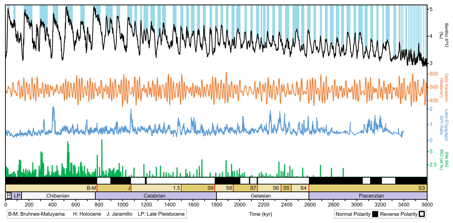
Figure 1Proxy records – black graph shows the global oxygen isotope record (Lisiecki and Raymo, 2005), with blue bands indicating ice ages. Orange graph shows orbital variation influence on insolation that triggered glacial–interglacial cycles (Laskar et al., 2004). Blue graph is the productivity record at Lake El'gygytgyn, Siberia (Brigham-Grette et al., 2013). Green bars show ice-rafted detritus documented on the mid-Norwegian margin at ODP Site 642 (Krissek, 1989). Seismic units (brown boxes) and age of key surfaces (labels with red lines) from Fig. 4 are shown.
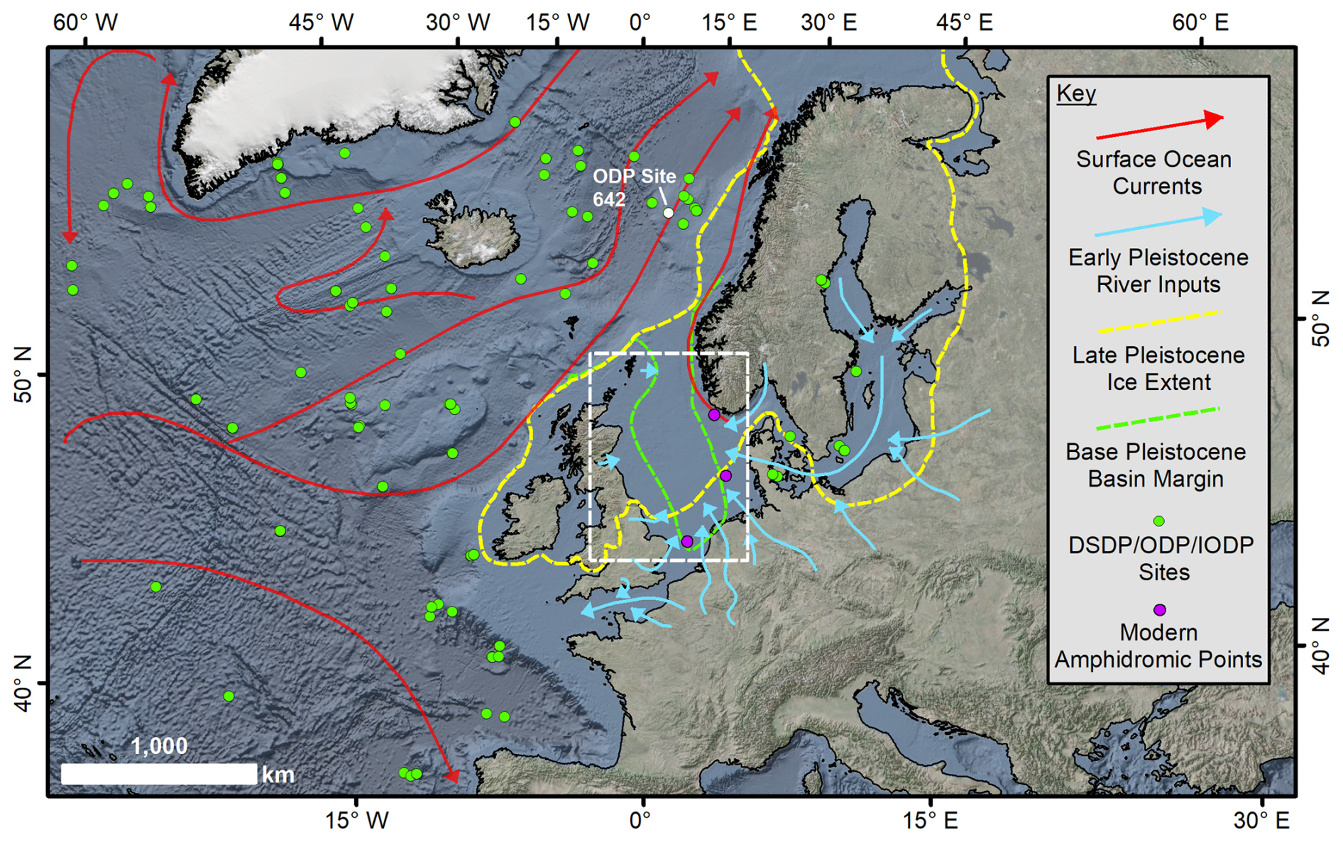
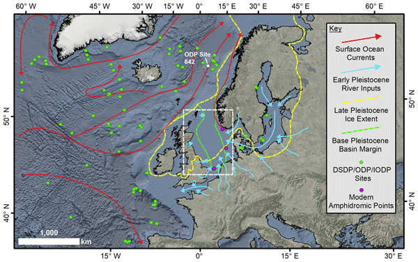
Figure 2Study site – regional context showing Early Pleistocene river inflow into the North Sea (Gibbard, 1988), Last Glacial Maximum ice extent (Hughes et al., 2016), and contemporary ocean surface currents. Purple dots show modern amphidromic points (Sinha and Pingree, 1997). The map highlights the large geographical extent of NSB sediment transport pathways. Green dots show existing ocean drilling sites – note the North Sea absence. White box shows location of Fig. 3. Ocean Drilling Program (ODP) Site 642 from Fig. 1 is highlighted. Basemap is from ArcGIS Pro mapping software. Basemap © Esri, Garmin, GEBCO, NOAA NGDC, and other contributors.
2.1 Geological setting
The NSB structural configuration results primarily from Late Jurassic to Early Cretaceous rifting and later regional uplift, followed by thermal cooling and subsidence (Jarsve et al., 2014). The basin is surrounded by land, except for a persistent northern link with the north-east Atlantic and a connection to the Channel region that only developed during the last 500 ka. Since the Neogene, up to 2 km of sediment has accumulated in the Central Graben, of which up to ∼ 1.2 km is Quaternary aged (Fig. 3) and is largely undisturbed, except near salt diapirs (Knutz, 2010). Basin-scale 3D seismic data show that at ∼ 2.6 Ma the North Sea formed an elongate depression with a narrow marine connection to the north (Lamb et al., 2018). North-westward progradation of shelf deltaic systems in the south and glaciogenic-linked progradation in the central/northern North Sea gradually infilled the Early Pleistocene basin with sediments from glaciation and the Baltic/Rhine–Meuse river systems (Lamb et al., 2017, 2018; Ottesen et al., 2018) (Fig. 2). Basin-scale age models have been developed from limited core materials (Kuhlmann and Wong, 2008; Knutz, 2010; Lamb et al., 2018) and allow for subdivision of Early Pleistocene stratigraphy, from inception at ∼ 2.6 Ma to the Middle Pleistocene Transition (MPT – ∼ 1.2-0.8 Ma).
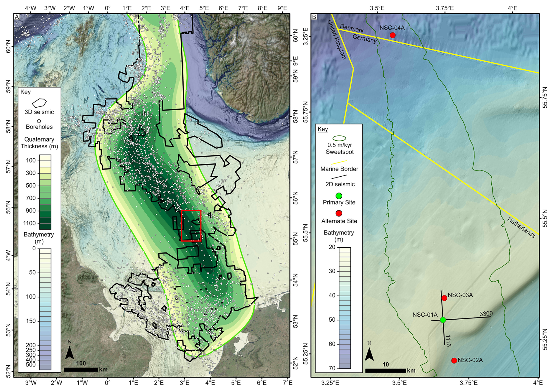
Figure 3Quaternary context – (A) thickness map of NSB Quaternary depocentre and the extent of industry data used to plan drill sites. 2D seismic data are not displayed for clarity but cover the entire basin. Red outline shows the location of panel (B). Note the non-linear colour scale for the bathymetry to highlight shallower morphology. (B) Map showing the location of the primary study site (NSC-01A), with the location of the seismic lines shown in Fig. 4, and the alternate sites. The green outline shows the area of maximum sedimentation rates for the targeted units – i.e. the “sweetspot” – and within this the geohazard workflow was deployed to identify potential drill sites. Bathymetry data from the EMODnet Bathymetry Consortium (2018) and the satellite imagery is the World Imagery layer on ArcMap Online. Bathymetry data © EMODnet Bathymetry Consortium, 2018. World Imagery © Esri, Maxar, Earthstar Geographics, and the GIS user community.
The Plio-Pleistocene intensification of glaciation, which strengthened during the MPT, is preserved within the NSB. While direct glacial evidence is scarce (e.g. Graham et al., 2011), 3D seismic data reveal extensive Early Pleistocene glacial landforms on buried clinoform surfaces (e.g. Knutz, 2010; Rea et al., 2018). The limited chronological control from borehole A15-03 (Kuhlmann et al., 2006) means that these features have led to contrasting interpretations. The “extensive ice sheets” model puts the earliest ice advance from the British Ice Sheet into the central basin early in the Pleistocene at ∼ 2.53 Ma, with the confluence of the British and Fennoscandian ice sheets in the North Sea at ∼ 1.87 Ma (Rea et al., 2018). In contrast, the “restricted ice sheets” model suggests that while the earliest Pleistocene Fennoscandian Ice Sheet reached the palaeoshelf break beyond western Norway (Ottesen et al., 2018; Løseth et al., 2020), this ice sheet did not reach the centre of the basin until ∼ 1.1 Ma (Ottesen et al., 2024). The contrasting interpretations provide significant uncertainty as to glaciation extent and timing, limiting our ability to interrogate the causes and consequences of global climate shifts such as the MPT. The NSB succession is largely unsampled by exploration wells but is well-imaged and sporadically sampled by site surveys (Buckley, 2017). Thus, some information exists for the Middle–Late Pleistocene (since ∼ 0.5 Ma), but it remains far from ideal for dedicated palaeoenvironmental analysis. From limited samples, key associations have been derived between ice sheet growth/decay and changes in sea surface temperatures, ecosystem extent (e.g. arboreal vegetation), and migration of Arctic surface water masses (Donders et al., 2018). In contrast to the Pleistocene, limited samples from the Pliocene show significant warmth compared to present (Kuhlmann et al., 2006; Dearing Crampton-Flood et al., 2020) with different flora and fauna that provide fundamental insights into a warm-state end member for the NSB and an analogue for climates under CO2 levels similar to today.
2.2 Seismic studies
Basin-wide seismic data and hundreds of boreholes allow for a 3D chronostratigraphic framework of the late Plio-Pleistocene to be mapped over areas up to ∼ 100 km2 (Fig. 3). The chronostratigraphy hinges on just one detailed seismic-well tie in exploration well A15-03 (biostratigraphy, palynology, palaeomagnetism) (Fig. 4), and wireline data calibration points (see Kuhlmann et al., 2006; Harding, 2015). Seismic reflections can be mapped around A15-03 and correlated outwards to create regional time-representative surfaces (Lamb et al., 2018; Busschers et al., 2025). These two-way-time surfaces have been depth-converted (Lamb et al., 2018), with subsequent thickness maps and the A15-03 age constraints being used to create sedimentation rate maps. Areas with high sedimentation rates (≥ 0.3 m kyr−1) were further investigated to identify mud-prone clinothem foresets/toesets with good continuity of desirable seismic facies that were calibrated against nearby borehole data (cuttings and wireline logs) to show potential drill site areas. Drill site locations were de-risked by documentation of drilling hazards and exclusion zones using a geohazard workflow (Cox et al., 2020). Cenozoic shallow gas occurrences in the southern North Sea were calibrated in nearby boreholes and, where possible, documentation of drilling hazards from well reports were integrated within the workflow. Further consideration was given to the depth of the target interval and the full overburden characteristics to maximise continuity of the record, such that it accurately reflected the depositional history of the interval of interest while minimising potential drilling challenges. The spatial distribution of geohazard zones, stratigraphic targets, and known hazardous objects (e.g. pipelines) was used to identify suitable primary (Fig. 4) and alternate drill site locations that were compatible with the broader scientific objectives of IODP3 Expedition 507 (next section).
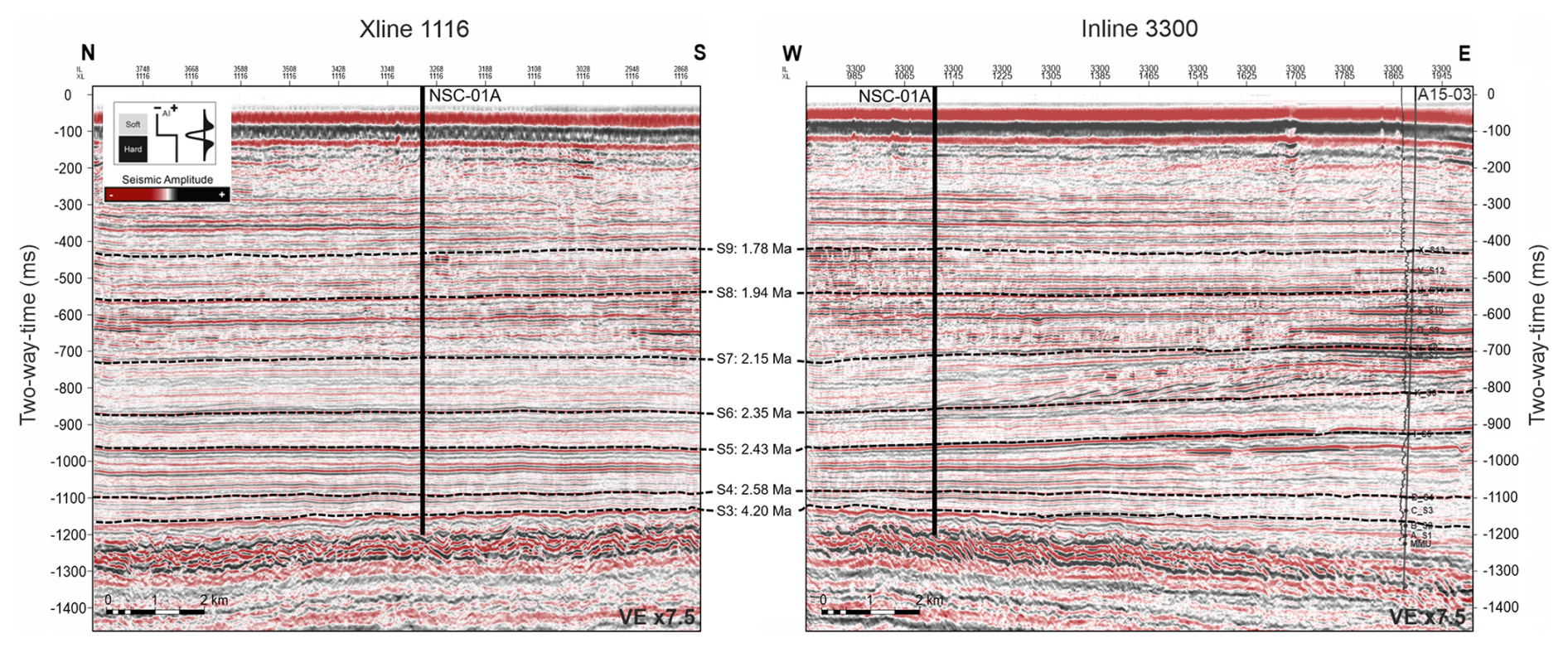
Figure 4Drill site profiles – seismic lines showing the seismic stratigraphy of the primary site, NSC-01A (vertical black line). Dashed black lines show key seismic unit reflectors with the associated dates from the A15-03 geochronology. Location of borehole A15-03 is also shown. Locations of the lines shown in Fig. 3.
The NSB mid-latitude location, latitudinal range, complete 3D seismic stratigraphic framework, and the multiple catchments and processes feeding materials into a subsiding basin at different times with high sedimentation rates provide a unique opportunity to unravel the palaeoclimatic and oceanographic evolution of north-west Europe in unprecedented detail. This campaign will help elucidate how glaciers, landscapes, climates, and shallow marine and coastal ecosystems evolved through a period of high-amplitude climate variability (Fig. 1). The current North Sea has warmed at twice the global average and, therefore, has a non-linear response to climate forcing that needs quantification (Edwards et al., 2021; Holland et al., 2023). The regional climatic state drives cascading effects on nutrient cycling, ecosystem evolution, sediment transport, and carbon cycling in the North Sea (Fig. 5) and requires a greater knowledge on how these systems evolved through time periods of variable baseline characteristics (i.e. orbital parameters, ice sheets, climate, tipping points). This will improve knowledge on the fundamental mechanisms governing these processes, with strong relevance to contemporary and future change.
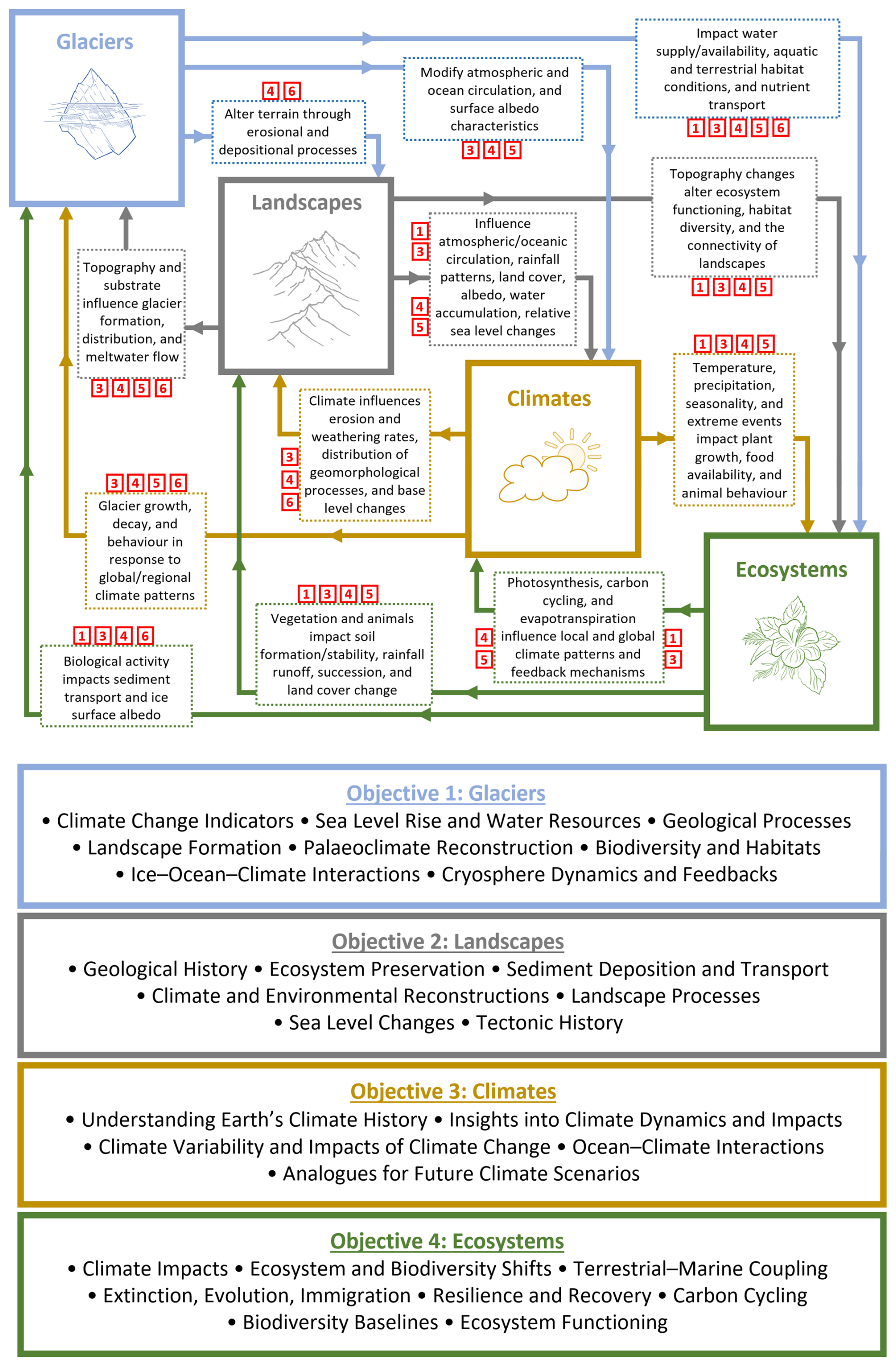
Figure 5Interlinked systems – flowchart summarising bi-directional relationships between glaciers, landscapes, climates, and ecosystems. Red numbered squares document how these links relate to Strategic Objectives in the 2050 Science Framework. The lower boxes provide a summary of broad topics that relate to each of the IODP3 Expedition 507 objectives.
3.1 Objective 1: Glaciers – when, where, and how did ice sheets develop around the NSB?
Knowledge on the evolution of Earth's contemporary ice sheets is limited by the observational time frame in which processes and rates of change can be documented. Reconstruction of palaeoice sheets provides information on initiation, growth, retreat, disappearance, and interaction with other parts of the Earth system – all are relevant for using past warm periods as future analogues. In the NSB, conflicting ideas on the Early Pleistocene glaciations are presented above – i.e. “extensive” vs. “restricted” – but the lack of empirical validation allows for the coexistence of both ideas; both may even be correct and represent ice sheets through different glacials (Newton et al., 2024). Regardless of different interpretations, ice advance beyond north-west European coastlines in the Early Pleistocene is unequivocal.
During the last glacial cycle, the European ice sheet contained 15–25 m global sea level equivalent (Simms et al., 2019). For the Pleistocene glaciations it is assumed the North American ice sheet dominated global sea level fluctuations (Lisiecki and Raymo, 2005; Spratt and Lisiecki, 2016). However, with Early Pleistocene fluctuations often ∼ 50 %–60 % lower in magnitude than the Middle–Late Pleistocene, landform evidence from north-west Europe means that the North American ice sheet was not always dominant and/or the magnitude of Early Pleistocene sea level changes may be incorrect (Newton et al., 2024). These uncertainties raise complications for our wider understanding of Pleistocene ice sheet history and how European ice sheets are accounted for in sea level reconstructions. In a global context this is an increasingly problematic observation because evidence for extensive Early Pleistocene ice sheets has grown for all glaciated margins, while the magnitudes of the associated sea level changes have generally not (Newton et al., 2024).
While there is limited knowledge on NSB sediment provenance during the earliest glacial–interglacial cycles (Kuhlmann et al., 2004), the lack of core material means we do not know the timing of the first ice advance into the centre of the NSB, nor how many times ice advanced afterwards or where it came from. Seismic geomorphology provides insights, but without materials to constrain these observations our knowledge remains limited on how ice sheets varied through 41 and 100 kyr glacial–interglacial cycles. We also do not know how ice sheets responded to changes in boundary conditions, such as infill of the NSB, or changes in oceanography.
Summary
Beyond the fact that icebergs and grounded ice occasionally entered the NSB, we know little about timing, origin, and characteristics. This uncertainty is important because ice sheet volumes impact global sea level reconstructions, our understanding of NSB connectivity with the North Atlantic, and how sensitive ice sheets were to different orbital and landscape settings. These are existential gaps in our knowledge of European palaeoglaciology that profoundly impact our understanding of global Pleistocene glaciation. The first objective of a successful drilling campaign will be to provide knowledge on when Pleistocene ice sheet glaciations occurred in north-west Europe, where the ice sheets were centred, and how these ice sheets and their associated feedbacks evolved.
3.2 Objective 2: Landscapes – how did the landscapes around the NSB evolve?
Landscape evolution of the North Sea region is complex because it is subject to reciprocal changes in glaciology, climatology, and ecology. The depositional environment of the NSB has transitioned through different landscape types: from shelf-deltaic to glaciogenic and contouritic (Ottesen et al., 2018). Up to ∼ 1.2 km of sediments have been deposited over ∼ 2.6 Myr, which provides the opportunity to explore land-to-sea coupling by documenting changing sources and catchment hydrology of north-west Europe's major river systems (Donders et al., 2018; Dearing Crampton-Flood et al., 2020). Coring will provide information on provenance, fluxes, and transport history of fluvio-deltaic and glaciogenic deposition in the NSB, with changes associated with climatic, hydrological, and glaciological evolution across the north-west European continent. Sedimentological analyses will provide insights into the relative contributions of glacial and fluvial processes, and their evolution across, and within, glacial–interglacial cycles (Kuhlmann et al., 2004).
Infill of the NSB has been hypothesised as a contributing factor facilitating ice sheet confluence in the central North Sea during the latest Early Pleistocene and the MPT (Ottesen et al., 2018), while regolith around the basin may have influenced ice sheet flow and geometry (Rea et al., 2018). Both ideas are important for understanding the triggers of major environmental changes across north-west Europe, but they lack empirical validation. The proposed coring site will be able to document regolith within the stratigraphy, determine what its source area was, when it first appeared in the depocentre, and when it disappeared as materials became fresher in origin through time. This will provide evidence for testing ideas on the relationship between regolith and ice sheet geometries (Clark and Pollard, 1998).
An improved chronology will capture short-term (∼ 10 kyr) and long-term (∼ 100 kyr) cycles of erosion-deposition around the North Sea. The erosion of the Fennoscandian mountains and subsequent accumulation of materials within the NSB have previously been linked with isostatic changes to explain tectonic-scale uplift (Nielsen et al., 2009). Such ideas have proven contentious but are important for understanding the efficacy of erosion and isostatic compensation. Additionally, estimates of subsidence in the NSB vary substantially (Arfai et al., 2018; Rea et al., 2018), and an improved knowledge on erosion cycles will contribute to these debates by providing insights into erosion rates and its wider impact on landscape evolution.
Summary
The scale of the drainage networks flowing into the NSB from across north-west Europe, coupled with repeated glaciation, means that a coring campaign will provide insight into landscape evolution and its links with climatic changes across the European continent. The results will feed into conceptual discussions of global significance on topics such as the role of regolith in ice sheet development, the influence of ice sheets on tectonic movements, and the characteristics of the MPT. The second objective of a successful drilling campaign in the NSB will be to provide knowledge on how landscapes around the NSB evolved and impacted other parts of the Earth system through the late Plio-Pleistocene.
3.3 Objective 3: Climate – how did climate evolve across different timescales?
The conceptual picture of late Plio-Pleistocene climate change is relatively simple: decreased pCO2 levels lowered global temperature and the climate became more responsive to orbitally driven insolation changes (Fig. 1). The knowledge of these changes is poorly understood at different spatio-temporal scales (Tzedakis et al., 2017). Understanding climate evolution across multiple scales is important because it directly relates to ice sheet development and landscape modification (Objectives 1 and 2). We know global atmospheric and oceanographic changes occurred across the Plio-Pleistocene boundary and likely impacted European climate (Bridges et al., 2023; McClymont et al., 2023), but we have limited information on what form these impacts took due to a fragmented onshore record and the lack of materials collected from the offshore realm.
An improved understanding of north-west European Pleistocene climate would allow us to study how climate could facilitate or restrict ice sheet growth around the NSB (Sánchez Goñi et al., 2023). We would learn whether climate conditions could support ice sheets during a 41 kyr glacial–interglacial cycle that were comparable in size to 100 kyr cycles (Rea et al., 2018). There are complex feedbacks between different parts of the Earth system, and understanding climate evolution at scales beyond a single glacial–interglacial cycle would allow for exploration of how climate, landscapes, ecosystems, and glaciers interacted (e.g. Toucanne et al., 2009).
The final timescale would explore how climate evolved within, and between, different glacial–interglacial cycles, including super-interglacials (Brigham-Grette et al., 2013) (Fig. 1). This is important because some Pleistocene interglacials are viewed as potential analogues for future climate change (e.g. Marine Isotope Stages 11, 19, 31, 81, 91, 93). Successful drilling would provide insights into whether there is evidence for rapid climate changes or polar amplification during deglaciations and at what stage of a climate cycle, if any, feedback loops reached tipping points and broke down. Study of key interglacials would allow for an assessment of whether the super-interglacial signatures observed at Lake El'gygytgyn, Siberia, were replicated in north-west Europe and what potential implications this would have for global vs. regional climate responses. An improved knowledge on climate variation across glacial–interglacial cycles would elucidate what factors provided important controls on ice sheet growth and decay. Such an understanding is crucial for European climate reconstructions and how regional changes might impact, or be impacted by, changes elsewhere (Brovkin et al., 2021).
Improving knowledge on oceanic connections between the NSB to the North Atlantic is significant. If there was a gateway – i.e. an ice sheet did not block the northern North Sea – fluvial and glacial freshwater from the NSB could flow into the North Atlantic and impact the Atlantic Meridional Overturning Circulation. Such connections could influence the position of Northern Hemisphere pressure systems and jet stream positioning, impacting precipitation and temperature patterns. This knowledge could improve our understanding of the impact and evolution of teleconnections across glacial–interglacial cycles.
Summary
Insights into climate variability and vulnerability to perturbations, the large-scale structure of atmospheric–oceanographic circulation systems, rates/magnitudes of change, and how different Earth spheres interacted across different timescales are all relevant to contextualising contemporary climate change and are of regional and global significance. The third objective of a successful drilling campaign in the NSB will be to provide knowledge on north-west European climate evolution over different climatological timescales, from within and across glacial–interglacial cycles and major global transitions like the MPT.
3.4 Objective 4: Ecosystems – how did ecosystems respond to climate changes and what can this tell us about thresholds relevant for contemporary and future biodiversity?
The increasingly intense glacial cycles during the Pliocene-Pleistocene transition significantly impacted marine and terrestrial ecosystems and biodiversity. Prior to 3.3 Ma, the North Sea was a warm-temperate mesophotic ecosystem with high diversity on the shelf areas and in surrounding lowlands. In the early Quaternary these ecosystems became dominated by low diversity and more cold-adapted biota. There is little knowledge on the exact timing and trajectories of biodiversity and ecosystem turnover during this period. A successful drilling campaign would establish baseline variability, identify regime shifts, and examine climatic triggers from biotic proxies. Furthermore, a high stratigraphic resolution will enable a better understanding of terrestrial–marine ecosystem feedback loops (Donders et al., 2018) and help document carbon and nutrient fluxes over glacial cycles, as well as how these changed over time.
An important component of this objective is to investigate how super-interglacials (Brigham-Grette et al., 2013; Oliveira et al., 2017; Tzedakis et al., 2017) are recorded in the NSB. High-resolution temporal records in the NSB will provide insight into how resilient communities were during the super-interglacials and whether there is evidence for biodiversity evolution and, importantly, tipping points that might have led to marine death zone development, which may be relevant for contemporary (and future) warming. Comparison of individual interglacials and super-interglacials will provide wider knowledge on the pace of turnovers, timescales of ecosystem resilience or failure, thresholds in ecosystem structure, and what the characteristics of ecosystem diversification and evolution were through climate changes of different durations and magnitudes, in both marine and terrestrial habitats. This improved understanding of the marine and terrestrial species in the NSB will provide broader insights into what the oceanic, atmospheric, and hydrologic systems looked like at various stages through the late Plio-Pleistocene (e.g. Lee et al., 2006). Knowledge on these ecosystem characteristics is important because it will help to elucidate the driving mechanisms of change, the feedbacks between different ecosystems, and the associations with the glacial and deltaic processes that operated. These relationships are important for characterising the dynamics of the regional carbon cycle, as well as wider biogeochemical cycling as ecosystems responded to variable depositional-erosional processes, and hydrological, climatic, and oceanographic regimes.
Summary
Documenting the timing, duration, and nature of ecosystem turnover events, and understanding the role of climatic change in triggering threshold responses, is important for establishing when and why ecosystems undergo fundamental reorganisation. Climate records derived from proxies such as dust, pollen, leaf waxes, and micropalaeontology – which have been effective in the NSB (Noorbergen et al., 2015; Donders et al., 2018) – all provide information linked with other parts of the Earth system (e.g. Objectives 1–3). This has direct implications for our understanding of the habitability of life on Earth and how this may relate to future ecosystem changes. The fourth objective of a successful drilling campaign in the NSB will be to provide knowledge on how ecosystems responded to past climatic tipping points and longer-term climatic changes.
3.5 Summary
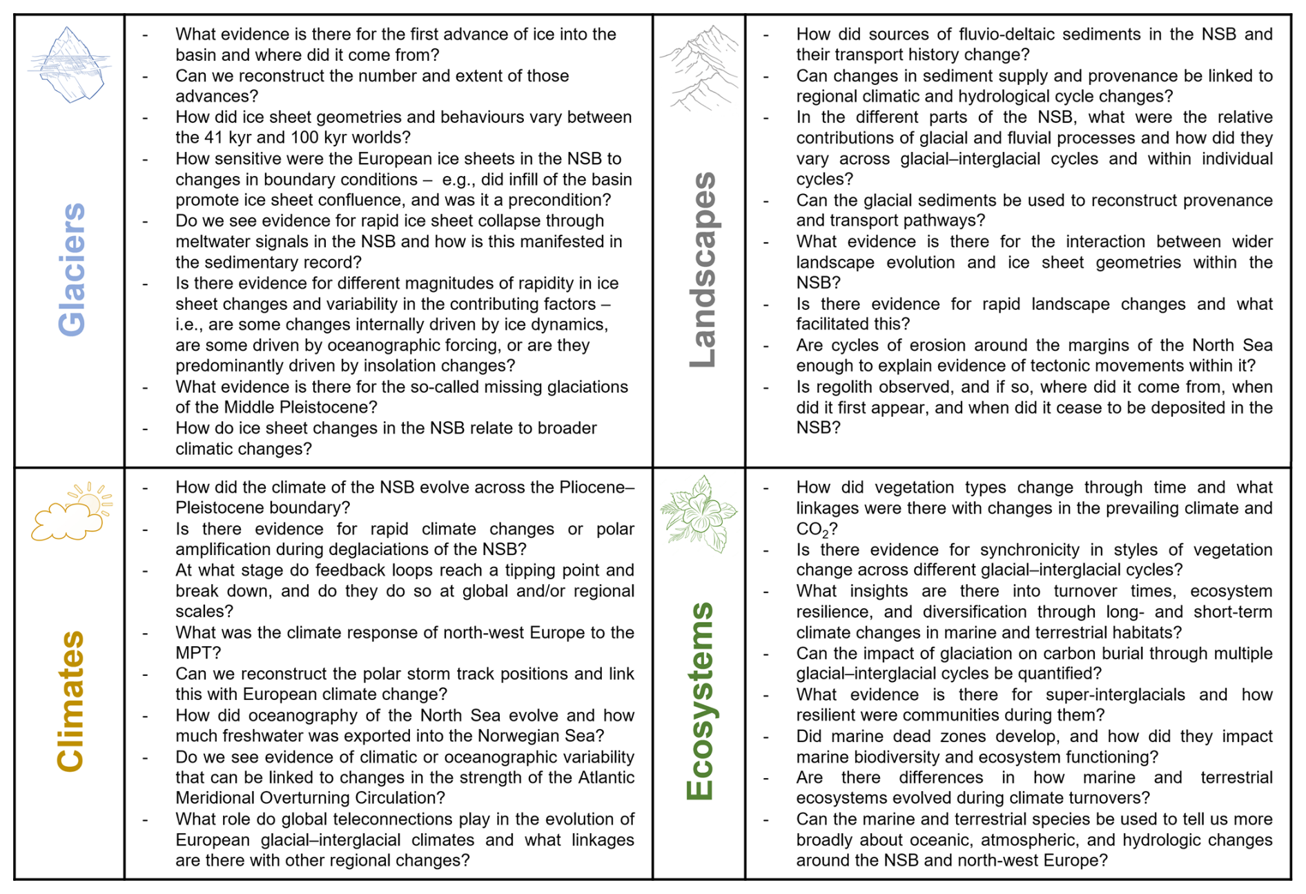
A successful coring campaign will deliver on the bullet points below, with specific research questions presented in Fig. 6:
-
a late Pliocene and Pleistocene chronostratigraphic record of the NSB;
-
reconstruction of glaciation in the NSB, including the nature and extent of these glaciations;
-
insights into the landscape dynamics and how infill of the NSB impacted other parts of the Earth system, such as ice sheets and the Baltic river system;
-
knowledge on how north-west European climate evolved through glacial–interglacial cycles, within individual cycles, the potential for tipping points, and analogues for how warmer European climate functioned;
-
ecosystem reconstructions through different environmental changes, providing insights into speciation, extinction, longevity, turnover times, and response;
-
insight into how different Earth-system components interacted and their sensitivity through the transition into the Pleistocene glaciation and the subsequent glacial–interglacial cycles.
-
These outcomes will provide the world's most integrated record of glaciological, geological, climatological, and biological changes for the late Plio-Pleistocene period.
3.6 IODP3 Expedition 507 and the 2050 Science Framework (2050-SF)
3.6.1 Strategic Objectives (SO)
Habitability of life will be explored through investigating how NSB ecosystems evolved through climatic changes of the late Plio-Pleistocene. The environmental conditions of this period include fluctuations through glacial–interglacial cycles, super-interglacials, and significant coastline migrations. This will provide knowledge on limits to and changes in productivity, food web structures, and biodiversity in the NSB and feedbacks with carbon cycling, climate change, and ocean health (SO-1 of the 2050-SF). This also aligns with SO-6 by contributing to an improved understanding of biogeochemical cycles and their relation to CO2 sequestration, microbial processes, and transport of matter between different reservoirs. Earth's climate system, feedbacks within it, and potential for tipping points are integral to SO-3-5. Drilling the NSB would contribute new insights into how variable and susceptible natural systems were to major global climatic changes. Analogues of past warmer climates and how they can be used to understand the drivers of tipping points, rates of change, and the spatial scale of their influence will be studied – all are important for future projections. IODP3 Expedition 507 will build knowledge on how tipping points were triggered, whether it was global, regional, or local processes, the length of time for stability to arise after tipping points were crossed, and what that new stability looked like. The drilling will provide new understanding of ecosystem health and stability through time, the level of resilience, and the consequences for adaptation, speciation, and recovery. The land-to-sea evolution of the NSB will provide insight into biologically driven feedbacks, the consequences and recovery of biodiversity under different perturbations, and impacts on carbon dynamics. The mid-latitude location allows for assessment of linkages with other latitudes and studying polar amplification during mid-latitude glaciation and its impact on sea level. It will provide insight into potential feedbacks of north-west European climate – e.g. North Sea influence on Nordic seas circulation, North Atlantic primary productivity, and the influence of European ice sheets on storm tracks. Improved knowledge on glacial–interglacial cycling in time periods with different boundary conditions will allow for the impact of those conditions on ice sheet evolution to be investigated. Tectonic feedbacks will be studied through glacial erosion and deposition, regolith transport, and how these processes relate to regional isostatic compensation.
3.6.2 Flagship Initiatives (FI)
The results will tie with 2050-SF FI-1 (ground-truthing future climate change) by providing empirical data for testing numerical Earth-system models, improving knowledge of climate sensitivity and variability, and contributing to a wider appreciation of Earth-system feedbacks. FI-4 will be addressed by exploring how productivity, geochemical characteristics (e.g. pH, oxygen levels), nutrient availability, and biodiversity of the North Sea changed through different glacial–interglacial cycles. The ability to cover such a wide range of themes, at a scale capturing changes across north-west Europe that are regionally and globally important, can only be achieved through continuous coring and logging of this unique succession. That such insight can be generated from a modest amount of drilling emphasises why this region is especially well-suited to ocean research drilling.
3.6.3 Enabling elements (EE)
The objectives of this expedition will provide knowledge on an array of topics relating to the impact of scientific drilling, such as improving climate models, assessing ocean health, and documenting biosphere evolution, all of which help to contextualise contemporary environmental change. IODP3 Expedition 507 will unite colleagues from numerous disciplines across NSB member states and the IODP3 community. This will ensure knowledge gained from the expedition will be used as effectively as possible – a key requirement of EE-1 in the 2050-SF. The nature of basin infill means the NSB geological record will provide insights into late Plio-Pleistocene sea level changes and its interaction with other parts of the Earth system. Proponents on this project are also working with materials from onshore drilling (e.g. the Netherlands) that will allow for an integrated land-to-sea insight; this relates to EE-2. Finally, the variety of information on past environments that will be extracted from the NSB means that a drilling campaign will contribute to EE-4 by providing geophysical, geochemical, and biological data that help improve future climate projections. This is crucial because the NSB region has never been drilled by IODP3 (or previous iterations), and, although it has been drilled by industry, there are no cores or data of the scale and quality that are required for ground-truthing climate models.
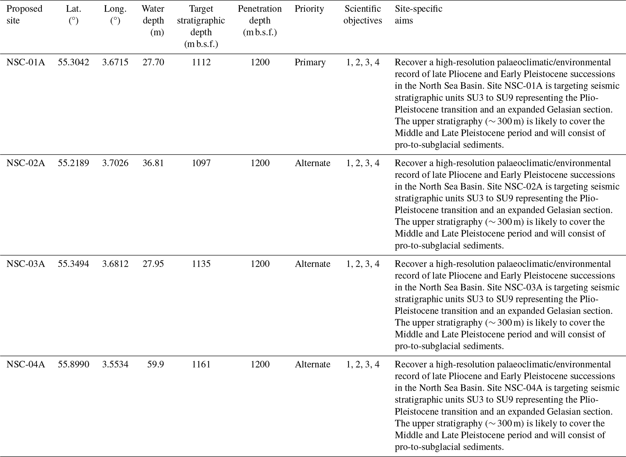
4.1 Proposed drill sites
One primary site (NSC-01A) and three alternate sites (NSC-02A, NSC-03A, and NSC-04A) have been identified to capture the depositional and climatic history of the North Sea Basin since the late Pliocene and into the Early Pleistocene (Table 1). Integrated seismic reflection and borehole data were used to target a thick, stratigraphically continuous, fine-grained succession spanning seismic units SU3–SU9 while avoiding structurally complex or gas-charged intervals, other geohazards, and existing infrastructure. Alternate sites provide comparable scientific relevance and operational suitability should permitting or site-specific drilling conditions preclude use of NSC-01A. All sites were evaluated using the same scientific, safety, and operational criteria (Newton et al., 2026). Primary Site NSC-01A (Fig. 4) targets high-resolution records of the late Pliocene and Early Pleistocene intervals, potentially extending from ∼ 3.3 Ma. Seismic geometries and nearby well data indicate predominantly muddy to fine-grained marine (shelf deltaic) sediments with upward coarsening due to progradation. The upper succession (above ∼ 1.78 Ma) likely comprises unconsolidated fine- to medium-grained sands interbedded with clays, whereas intervals below 400 m below sea floor (m b.s.f.) are expected to consist of interbedded silty clays, silts, and very fine- to medium-grained sands, with occasional limestone stringers. Ice-rafted debris may occur within Early Pleistocene topset strata (2.1–1.7 Ma). The uppermost 300 m is interpreted as a heterolithic sequence spanning the last ∼ 800 kyr.
4.2 Drilling strategy
Recent drilling of glaciated continental margins, including International Ocean Discovery Program (IODP) Expedition 400 (north-west Greenland), has demonstrated the operational challenges of penetrating compacted subglacial sediments using advanced piston coring (APC) systems (Knutz et al., 2024). Comparable subglacial facies are anticipated in the uppermost intervals of the primary site, where recovery may vary. To maximise efficiency and recovery, rotary core barrel (RCB) coring will be prioritised to reach the full target depth at the site with good recovery. Although RCB coring may reduce recovery of sand-rich intervals, it is expected to optimise recovery of the deeper, mud-dominated units that form the primary scientific targets of the expedition. APC coring will be available and may be deployed depending on geological context. Current estimates provided by the European Consortium for Ocean Research Drilling (ECORD) Science Operator indicate an average coring rate of approximately 30–50 m per day – this is subject to revision once the final drilling vessel/platform is selected. Drilling will proceed through successive coring and downhole logging phases. Based on previous IODP experience, expected recovery of glaciogenic sediments ranges from 13 %–65 %, though the deeper, mud-dominated strata targeted here are likely to yield significantly higher recoveries (> 70 %) owing to compaction and reduced sand content.
4.3 Logging strategy
Integrated downhole logging and core–log–seismic correlation will be applied to maintain stratigraphic continuity and ensure robust age control throughout the hole. The drilling programme will include a comprehensive suite of downhole logging operations designed to obtain a continuous, high-resolution record of the lithological, physical, and structural characteristics of the recovered sequences. Planned measurements include spectral gamma ray, sonic velocity, electrical resistivity, porosity, borehole imaging, and magnetic susceptibility. Although existing boreholes in the region provide partial control on subsurface velocity, they are typically located several kilometres from the proposed site and optimised for greater depths than those targeted by IODP3 Expedition 507. Consequently, check shot surveys are considered essential, and the preferred programme will include a suite of vertical seismic profiling, where operationally feasible. These measurements will provide the velocity control required to generate synthetic seismograms and establish a robust core, log, and seismic tie to the regional 3D seismic framework. The final configuration of the logging strategy will be refined once the vessel, source availability, hole conditions, and operational parameters are confirmed.
IODP3 Expedition 507 will be implemented as a Mission Specific Platform (MSP) operation comprising one primary borehole and three designated alternates. Operational and environmental risks are expected to fall within the standard range for MSP activities and will be managed following ECORD and IODP3 operational safety and risk protocols, as also assessed by the IODP3 Safety and Environment (SEA) Group. Potential risks include adverse weather, equipment downtime, and variable subsurface conditions affecting core recovery and drilling. These risks will be mitigated through flexible scheduling, continuous monitoring of weather windows, and maintaining critical spares and backup systems onboard. All operational plans will incorporate buffer time to accommodate short delays without compromising the achievement of scientific objectives. If drilling conditions, technical constraints, or time limitations prevent full core recovery or continuity, downhole logging will be used to supplement data acquisition. Alternate sites may also be utilised to ensure that a representative stratigraphic sequence is obtained. Current operational assessments indicate that the full target depth can be achieved within the provisional timeline.
The offshore and onshore phases of the IODP3 Expedition 507 programme are designed to operate as a continuous analytical workflow. Offshore activities will focus on non-destructive measurements and limited sampling from cut ends to establish preliminary age control and environmental context. These initial results will inform the prioritisation of sampling and analysis once the cores are split onshore. The onshore phase will then expand upon these foundations through comprehensive palaeontological, sedimentological, geochemical, and chronological studies, ensuring that the full scientific potential of the recovered material is realised. The offshore and onshore programmes are designed to be adaptable, enabling modifications and additions that best leverage the collective expertise of the final expedition participants once they have been selected. A summary of methods is provided in Fig. 7.
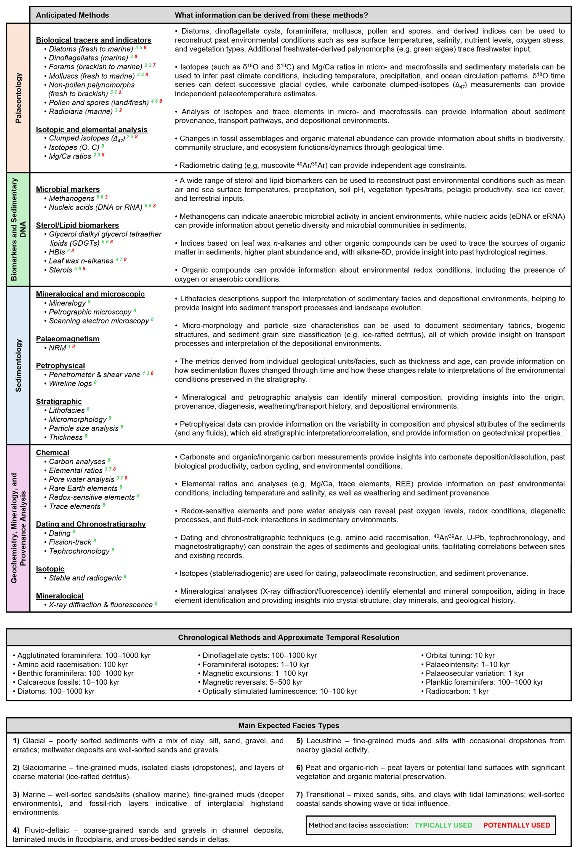
Figure 7Research priorities – summary of methods to be used. Superscript numbering in the top table relates to facies in the bottom table and shows which methods are typically (green numbers) used for studying that facies – e.g. dinoflagellates are typically used to investigate marine facies. Red numbering represents facies that may potentially be studied using that method, depending upon what materials are present. Number 8 represents methods that might potentially be applied to all the facies listed.
6.1 Expected offshore measurements
As the core will not be split offshore, sampling opportunities will be limited to the cut ends of each section. The offshore analytical plan focuses on limited discrete measurements that can guide early interpretation and planning of onshore work.
6.1.1 Sedimentology
Recovered core will capture the progradation and infill history of the North Sea Basin (NSB), providing a continuous record of depositional environments across the terrestrial–marine transition. Preliminary core description, undertaken through the intact core liner, will allow for documentation of the anticipated range of lithofacies, including terrestrial, coastal, shallow-marine, deeper-marine, and glacimarine units. As core sections arrive on deck, standard non-destructive core scanning techniques will be applied to measure key physical properties using the offshore Multi-Sensor Core Logger (MSCL), providing offshore datasets of parameters such as magnetic susceptibility, density, and P-wave velocity. Core photography will also be carried out to provide basic information on lithology and curation in a visual format and to provide information for onshore operations.
6.1.2 Chronology
A crucial deliverable for the IODP3 Expedition 507 is to develop a high-resolution chronology for the existing 3D seismic stratigraphic scheme of the North Sea. Sampled ends may be used to document planktic and benthic foraminifera, coccoliths, diatoms, and nannofossils. Documentation of organic-walled microfossils, such as dinoflagellate cysts, acritarchs, pollen, spores, and other microfossils with organic constituents, will also be compared with existing biostratigraphic schemes of the North Atlantic (e.g. De Schepper and Head, 2009). This analysis is expected to be provisional in nature while offshore to ensure that while approaching the base of the sequence the key Plio-Pleistocene transition is recovered. Some samples may be taken offshore and analysed immediately after the expedition to help target analysis during the onshore operations.
6.1.3 Palaeoenvironments
Micro/macrofossil assemblages will provide insight into how water conditions varied, the relative fluxes of freshwater into the NSB, the temperature ranges associated with glacial–interglacial cycles, sea-surface temperatures, sea ice cover, ecosystem changes, and productivity. Documentation of pollen and spores will elucidate details on the terrestrial environment as well as, potentially, initial insights into the hydrological regimes draining into the NSB and links with broader climatic patterns, such as the position of the North Atlantic storm front. From the sampled ends, these onboard microfossil assemblages (e.g. foraminifera) could also facilitate early estimates on palaeowater depths. Efforts will also be made to study pore fluid extractions, as well as specific protocols for ensuring microbiological work conducted onshore is not impacted by contamination (e.g. Knutz et al., 2024) – i.e. depending upon the final science team, some bespoke protocols may be put in place to allow for the preservation of materials if required for future DNA/biomarker work.
6.1.4 Wireline logging
The expedition expects to utilise a full suite of wireline logging measurements. This can be adjusted to expedition needs and will likely include porosity, resistivity, magnetic susceptibility, spectral gamma ray, sonic, and formation imaging. While significant efforts have been made to target mud-dominated strata that should facilitate excellent recovery rates, the nature of intermittent glaciogenic deposition in the region means that some intervals could have lower recovery rates. This means that wireline logs will provide a crucial insight into any intervals with poor recovery. The general operational plan will be to conduct the wireline logging after drilling, assuming that hole conditions permit. Check-shot and vertical seismic profiling acquisition will be undertaken alongside the logging programme, subject to vessel configuration, source availability, and hole conditions, to support the core, log, and seismic tie.
6.2 Onshore and post-expedition analyses
During the onshore operations stage, usually held 3–4 months after the offshore expedition, the cores will be split and undergo a suite of standard IODP3 physical measurements (e.g. magnetic susceptibility, porosity, shear strength, density, moisture, standard geochemistry). Further measurements and samples will be taken depending on personal sample requests in order to develop a more complex range of methods and build upon any initial interpretations and chronologies developed offshore or between the onshore and offshore operations. The plan outlined below identifies the priority methods that would ideally be employed. It is intended as an aspirational framework rather than a prescriptive set of requirements, thus it will evolve as techniques develop and the expertise of the expedition participants is confirmed – e.g. DNA methods are relatively new and have seen significant progress in recent years. For personal sample requests, samples will be taken during the onshore operations and analysed later by members of the Science Team. The analytical programme links directly to the four scientific objectives: provenance and glacial indicators will reconstruct ice-sheet source and extent (Objective 1); facies, sediment flux, and core, log, and seismic integration will resolve landscape and depositional evolution (Objective 2); the integrated age model and climate and ocean proxies will reconstruct variability across timescales (Objective 3); and fossil, biomarker, sedimentary ancient DNA, and biogeochemical records will document ecosystem change (Objective 4).
6.2.1 Palaeontology
Any initial foraminifera and dinoflagellate analyses conducted directly after the offshore operations will be advanced further by documenting other micro/macroscopic fossil assemblages to determine palaeoenvironmental conditions. Layers with a sufficient abundance of benthic and/or planktic species will be used for further isotopic analyses (e.g. δ18O and δ13C) and development of temperature proxies (Mg Ca, Δ47) through time to reconstruct water temperature and salinity. The fossil assemblages will be used to further develop the preliminary biostratigraphy. Analysis will also include the identification of pollen and non-pollen palynomorphs that might be used to reconstruct past vegetation, relative sea level, and climate dynamics. These will be combined with siliceous (diatoms) and organic-walled microfossils (e.g. dinoflagellate cysts, acritarchs, ciliates, freshwater algae) to elucidate information on sea-surface conditions – e.g. stratification, circulation, salinity, temperature, and freshwater flux. These methods will be complemented by foraminifera analyses, providing information on sub-surface and bottom water conditions, including the potential use of isotopic signatures to differentiate between fluvial and glacial meltwater inputs. These methods will be combined with the biomarkers outlined below.
6.2.2 Biomarkers and sedimentary ancient DNA
A wide range of biomarkers have been developed in recent years, with many of them potentially applicable to the suite of post-cruise analyses proposed here. The following is not an exhaustive list but presents key priorities that would be targeted. Highly branched isoprenoids (HBIs) can be used as an indicator of sea ice extent and variability through time (Belt and Müller, 2013). Sterols, found in a range of organisms, can be used as biomarkers for pelagic productivity and possible terrestrial inputs to the marine environment from sources such as land plants and soils (e.g. Köseoğlu et al., 2018). Glycerol dialkyl glycerol tetraether lipids (GDGTs) are lipid molecules that can be used as biomarkers within sediments less than ∼ 140 Myr old (Schouten et al., 2013) and have been used on many glaciated margins to produce temperature reconstructions, including of offshore north-west Europe (e.g. Sinninghe Damsté et al., 2022). Leaf wax n-alkanes can be well-preserved in sedimentary successions and have previously been used in the North Sea region to reconstruct past vegetation types and their associated climatic conditions (e.g. precipitation) (Eglinton and Eglinton, 2008; Donders et al., 2018). These biomarkers, plus others, can be combined to help gauge a range of environmental characteristics, such as temperature, pH, vegetation types, and terrestrial/marine conditions and bacterial communities (Summons et al., 2021). Sedimentary ancient DNA has emerged as a unique tool in unravelling past ecosystems, and DNA has been retrieved from in situ marine sediments going back ∼ 1 Myr (Armbrecht et al., 2022) and from permafrost (including raised marine deposits) going back ∼ 2 Myr. A strict sampling procedure with contamination control will allow for these analyses to be undertaken (e.g. Knutz et al., 2024). This will involve using metabarcoding and/or metagenomics to characterise the eukaryote community structure and diversity. This approach allows for inclusion of many organisms, including those that do not form micro/macrofossils, into the ecosystem assessment.
6.2.3 Core characterisation and stratigraphic framework
After the sampling has taken place, it is expected that standard sedimentological techniques, such as particle size analysis, petrographic microscopy, thin-section analysis, X-ray diffraction, and scanning electron microscopy will be used to identify mineral composition, texture, shape, sedimentary structure, and any microscopic features (e.g. solution features) that may be indicative of weathering histories (e.g. fresh vs. aged). This will provide insights into the origin, transport history, facies types, and changes in the depositional settings that are captured on the coring campaign. A new high-resolution stratigraphy will be derived from these methods, and new geochronological constraints will be developed to provide a wider palaeoenvironmental framework for changes through the late Plio-Pleistocene. Age constraints will also be used with thickness measurements of different facies to calculate sedimentation rates and how their flux changes through time, adding greater detail to the stratigraphic scheme and its interpretations. Geotechnical properties will be measured through density, gamma ray, and resistivity logging, as well as shear vane and penetrometer to document changes in sediment properties, compaction, and layering. This will provide insight into any potential examples of over-compaction that might be associated with burial beneath palaeoice sheets. Palaeomagnetic analyses will be undertaken during the onshore phase, after the cores have been split. Natural remanent magnetisation (NRM) will be measured using non-destructive stepwise alternating field demagnetisation. As is standard practice, a cube sample will be extracted from the working half of each core section to determine NRM directions and comparison with existing geomagnetic excursions and major polarity chrons of the Pleistocene (Ogg, 2020). The high sedimentation rates targeted by the expedition should maximise the potential to resolve shorter-duration excursions. NRM intensities normalised by magnetic susceptibility and, where appropriate, laboratory-induced remanences may also be used to develop a relative palaeointensity record, building on previous palaeomagnetic work in the NSB (Stoker et al., 1983). The depositional age model will integrate seismic sequence stratigraphy, biostratigraphic datums, palaeomagnetic polarity reversals and excursions, stable-isotope stratigraphy where suitable foraminifera are preserved, and correlation of high-resolution physical-property and palaeoenvironmental proxy series with orbital forcing and the global marine isotope record. Calibrated lithological, chronological, and palaeoenvironmental interpretations will then be extended away from the borehole using mapped horizons, seismic facies, and attributes from the basin-wide seismic database. This will transform the one-dimensional core record into a spatial framework for assessing the distribution, geometry, and volume of fluvial, glaciogenic, and marine deposits and quantifying changes in sediment routing and deposition across the NSB through time.
6.2.4 Geochemistry, mineralogy, and provenance
A wide range of geochemical methods will be utilised in the post-cruise sediment analyses. This will include trace elements, isotopes (e.g. oxygen, carbon, nitrogen, sulfur), rare Earth elements, carbonate content (grain or compound-specific isotope analysis), and elemental ratios to interpret past environmental conditions, sediment sources, and processes. Radiogenic isotope analysis, detrital zircon U–Pb and muscovite 40Ar 39Ar dating, and Sm Nd isotopes will facilitate tracing sediment sources and characterising source-terrain evolution. More broadly, provenance analysis and lithological fingerprinting will distinguish sediment supplied by the British–Irish and Fennoscandian ice sheets, allowing for changes in their relative contributions, extents, and episodes of confluence to be reconstructed. Changes in organic carbon and total organic carbon content, as well as biogenic silica content of the sediments, will be combined with biomarkers (outlined above) to document how organic matter composition, environments, water properties, vegetation, and productivity changed through glacial–interglacial cycles and throughout the late Plio-Pleistocene. Mineral identification via X-ray diffraction for clay mineral analysis, magnetic susceptibility, and pore water analysis will help determine elemental concentrations, isotope composition, and oxidation-reduction conditions through the analysis of redox sensitive elements such as iron and manganese, facilitating an understanding of sediment sources, redox conditions, ages, and environmental changes. Some of these assessments will also contribute to understanding any diagenesis and post depositional transformations.
6.3 Data management
A comprehensive data management plan for the IODP3 Expedition 507 will be established following finalisation of data requirements, sampling strategies, and operational logistics. The plan will define the procedures for data acquisition, processing, quality control, storage, and dissemination to ensure consistency and traceability across all operational phases. The ECORD Science Operator (ESO) will oversee the use of the expedition mobile Drilling Information System (mDIS) as the primary data capture and management platform. All geological, geophysical, and operational metadata will be recorded in mDIS, enabling real-time input, visualisation, and reporting. Supplementary files, including imagery and analytical datasets not directly stored in mDIS, will be maintained on dedicated ESO file servers for archiving and long-term access. Following completion of offshore operations, the expedition database and file systems will be transferred to the Bremen Core Repository to support onshore core description, sampling, and analysis. Data access for the Science Team will be provided through a secure web-based interface during the moratorium period. After completion of quality assurance and review, all data and metadata will be archived within the appropriate IODP3 and ECORD repositories and made publicly accessible to ensure long-term preservation and scientific legacy.
6.4 Outreach
An outreach plan for the IODP3 Expedition 507 will be developed in collaboration with project partners and communications offices once operational and scientific details are finalised. While the timeline is restricted, the plan will aim to promote awareness of the expedition and its scientific objectives within the international research community, educational sectors, and the wider public. Depending upon feasibility, proposed activities may include coordinated media releases, web-based updates, and engagement through institutional and ECORD communication platforms. All outreach activities will adhere to ECORD and IODP3 communication guidelines to ensure consistency, accessibility, and maximum visibility of the scientific outcomes of the expedition. The legacy of the expedition will be supported through open access to data and imagery to encourage long-term knowledge exchange.
All applicants applying for membership of the Expedition Science Team should refer to the Sample, Data, and Obligations Policy (https://iodp3.org/documents/sample-data-obligations-policy/, last access: 1 April 2026). This document outlines the policy for distributing scientific ocean drilling samples and data to research scientists, curators, and educators. The document also defines the obligations that recipients of samples and data incur. The Sample Allocation Committee (SAC, composed of the Co-Chief Scientists, Expedition Project Manager, and IODP3 Curator or curatorial representative on board the ship) will work with the entire Expedition Science Team to formulate a formal expedition-specific sampling plan for shipboard and post-cruise sampling.
Shipboard scientists are expected to submit sample requests (at https://web.iodp.tamu.edu/SDRM/; 1 April 2026) ∼ 6 months before the beginning of the expedition. Based on sample requests (shore based and shipboard) submitted by this deadline, the SAC will prepare a tentative sampling plan, which will be revised on the ship as dictated by core recovery and cruise objectives. The sampling plan will be subject to modification depending upon the actual material recovered and collaborations that may evolve between scientists during the expedition. Modification of the strategy during the expedition must be approved by the Co-Chief Scientists, Expedition Project Manager, and curatorial representative on board the ship.
The minimum permanent archive will be the standard archive half of each core. All sample frequencies and sizes must be justified on a scientific basis and will depend on core recovery, the full spectrum of other requests, and the cruise objectives. Some redundancy of measurement is unavoidable, but minimising the duplication of measurements among the shipboard Science Team and identified shore-based collaborators will be a factor in evaluating sample requests.
If some critical intervals are recovered, there may be considerable demand for samples from a limited quantity of cored material. These intervals may require special handling, a higher sampling density, reduced sample size, sharing of samples, or continuous core sampling by a single investigator. A sampling plan coordinated by the SAC may be required before critical intervals are sampled.
Every member of the Expedition Science Team will be obligated to carry out scientific research for the expedition and publish the results, by contributing to the production of the Expedition Summary, Methods, and Site Reports in the Proceedings of the International Ocean Drilling Programme and by publishing in other scientific journals.
Staffing of the Expedition Science Team involves a competitive process following an open Call for Participation published on the IODP3 website (https://iodp3.org, last access: 1 April 2026). Applications are evaluated by the scientific ocean drilling Programme Member Offices, with staffing nominations taking into account both the scientific background of applicants, the scientific needs of the expedition, and programmatic national, gender, and career-stage balances.
Seismic reflection data used to determine site locations are available through national data repositories for North Sea states. Other data, such as the palaeoclimate proxies presented in Fig. 1, are available through the associated references.
AMWN prepared the initial draft of this document and figures, with further support and review from MAS, FSB, and USN.
The contact author has declared that none of the authors has any competing interests.
Publisher's note: Copernicus Publications remains neutral with regard to jurisdictional claims made in the text, published maps, institutional affiliations, or any other geographical representation in this paper. The authors bear the ultimate responsibility for providing appropriate place names. Views expressed in the text are those of the authors and do not necessarily reflect the views of the publisher.
The authors are grateful to proponents on the original proposal, especially Georgina Heldreich, Jane Huuse, Mads Huuse, Katrine Juul Andresen, and Heather Stewart for the site survey work that underpinned site selection. The Natural Environment Research Council are also thanked for financial support. Myriam Kars, Karsten Gohl, and Christoph Beier are thanked for comments and support during preparation and revision of the article.
This research has been supported by the Natural Environment Research Council (grant no. NE/W004925/1).
This paper was edited by Eun Young Lee and reviewed by Karsten Gohl and Christoph Beier.
Arfai, J., Franke, D., Lutz, R., Reinhardt, L., Kley, J., and Gaedicke, C.: Rapid Quaternary subsidence in the northwestern German North Sea, Sci. Reports, 8, 11524, https://doi.org/10.1038/s41598-018-29638-6, 2018.
Armbrecht, L., Weber, M. E., Raymo, M. E., Peck, V. L., Williams, T., Warnock, J., Kato, Y., Hernández-Almeida, I., Hoem, F., Reilly, B., Hemming, S., Bailey, I., Martos, Y. M., Gutjahr, M., Percuoco, V., Allen, C., Brachfeld, S., Cardillo, F. G., Du, Z., Fauth, G., Fogwill, C., Garcia, M., Glüder, A., Guitard, M., Hwang, J. H., Iizuka, M., Kenlee, B., O'Connell, S., Pérez, L. F., Ronge, T. A., Seki, O., Tauxe, L., Tripathi, S., and Zheng, X.: Ancient marine sediment DNA reveals diatom transition in Antarctica, Nat. Commun., 13, 5787, https://doi.org/10.1038/s41467-022-33494-4, 2022.
Balco, G. and Rovey, C. W.: Absolute chronology for major Pleistocene advances of the laurentide ice Sheet, Geology, 38, 795–798, https://doi.org/10.1130/G30946.1, 2010.
Belt, S. T. and Müller, J.: The Arctic sea ice biomarker IP25: a review of current understanding, recommendations for future research and applications in palaeo sea ice reconstructions, Quaternary Sci. Rev., 79, 9–25, https://doi.org/10.1016/J.QUASCIREV.2012.12.001, 2013.
Bridges, J. D., Tarduno, J. A., Cottrell, R. D., and Herbert, T. D.: Rapid strengthening of westerlies accompanied intensification of Northern Hemisphere glaciation, Nat. Commun., 14, 3905 , https://doi.org/10.1038/s41467-023-39557-4, 2023.
Brigham-Grette, J., Melles, M., Minyuk, P., Andreev, A., Tarasov, P., DeConto, R., Koenig, S., Nowaczyk, N., Wennrich, V., Rosén, P., Haltia, E., Cook, T., Gebhardt, C., Meyer-Jacob, C., Snyder, J., and Herzschuh, U.: Pliocene warmth, polar amplification, and stepped pleistocene cooling recorded in NE Arctic Russia, Science, 340, 1421–1427, https://doi.org/10.1126/science.1233137, 2013.
Brovkin, V., Brook, E., Williams, J. W., Bathiany, S., Lenton, T. M., Barton, M., DeConto, R. M., Donges, J. F., Ganopolski, A., McManus, J., Praetorius, S., de Vernal, A., Abe-Ouchi, A., Cheng, H., Claussen, M., Crucifix, M., Gallopín, G., Iglesias, V., Kaufman, D. S., Kleinen, T., Lambert, F., van der Leeuw, S., Liddy, H., Loutre, M. F., McGee, D., Rehfeld, K., Rhodes, R., Seddon, A. W. R., Trauth, M. H., Vanderveken, L., and Yu, Z.: Past abrupt changes, tipping points and cascading impacts in the Earth system, Nat. Geosci., 14, 550–558, https://doi.org/10.1038/s41561-021-00790-5, 2021.
Buckley, F. A.: A glaciogenic sequence from the Early Pleistocene of the Central North Sea, J. Quaternary Sci., 32, 145–168, https://doi.org/10.1002/jqs.2867, 2017.
Busschers, F. S., Cohen, K., Wesselingh, F., Bakker, M., Schokker, J., van Balen, R., and van Heteren, S.: Quaternary, in: Geology of the Netherlands, 2nd edn., edited by: ten Veen, J., Vis, G.-J., de Jager, J., and Wong, T., Taylor and Francis, 333–392, https://doi.org/10.5117/9789463728362_ch10, 2025.
Clark, P. U. and Pollard, D.: Origin of the middle Pleistocene transition by ice sheet erosion of regolith, Paleoceanography, 13, 1–9, https://doi.org/10.1029/97PA02660, 1998.
Cox, D. R., Knutz, P. C., Campbell, D. C., Hopper, J. R., Newton, A. M. W., Huuse, M., and Gohl, K.: Geohazard detection using 3D seismic data to enhance offshore scientific drilling site selection, Sci. Dril., 28, 1–27, https://doi.org/10.5194/sd-28-1-2020, 2020.
Dearing Crampton-Flood, E., Noorbergen, L. J., Smits, D., Boschman, R. C., Donders, T. H., Munsterman, D. K., ten Veen, J., Peterse, F., Lourens, L., and Sinninghe Damsté, J. S.: A new age model for the Pliocene of the southern North Sea basin: a multi-proxy climate reconstruction, Clim. Past, 16, 523–541, https://doi.org/10.5194/cp-16-523-2020, 2020.
De Schepper, S. and Head, M. J.: PLIOCENE AND PLEISTOCENE DINOFLAGELLATE CYST AND ACRITARCH ZONATION OF DSDP HOLE 610A, EASTERN NORTH ATLANTIC, Palynology, 33, 179–218, https://doi.org/10.2113/gspalynol.33.1.179, 2009.
Donders, T. H., van Helmond, N. A. G. M., Verreussel, R., Munsterman, D., ten Veen, J., Speijer, R. P., Weijers, J. W. H., Sangiorgi, F., Peterse, F., Reichart, G.-J., Sinninghe Damsté, J. S., Lourens, L., Kuhlmann, G., and Brinkhuis, H.: Land–sea coupling of early Pleistocene glacial cycles in the southern North Sea exhibit dominant Northern Hemisphere forcing, Clim. Past, 14, 397–411, https://doi.org/10.5194/cp-14-397-2018, 2018.
Edwards, M., Hélaouët, P., Goberville, E., Lindley, A., Tarling, G. A., Burrows, M. T., and Atkinson, A.: North Atlantic warming over six decades drives decreases in krill abundance with no associated range shift, Commun. Biol., 4, 1–10, https://doi.org/10.1038/s42003-021-02159-1, 2021.
Eglinton, T. I. and Eglinton, G.: Molecular proxies for paleoclimatology, Earth Planet. Sc. Lett., 275, 1–16, https://doi.org/10.1016/J.EPSL.2008.07.012, 2008.
EMODnet Bathymetry Consortium: EMODnet Digital Bathymetry (DTM), EMODnet Bathymetry, https://doi.org/10.12770/18ff0d48-b203-4a65-94a9-5fd8b0ec35f6, 2018.
Gibbard, P. L.: The history of the great northwest European rivers during the past three million years, Philos. Trans. R. Soc. London. B, Biol. Sci., 318, 559–602, 1988.
Graham, A. G. C., Stoker, M. S., Lonergan, L., Bradwell, T., and Stewart, M. A.: The pleistocene glaciations of the North Sea basin, in: Developments in Quaternary Science, edited by: Ehlers, J., Gibbard, P. L., and Hughes, P. D., Elsevier, 261–278, https://doi.org/10.1016/B978-0-444-53447-7.00021-0, 2011.
Harding, R.: Evolution of the Giant Southern North Sea Shelf-Prism: Testing Sequence Stratigraphic Concepts and the Global Sea Level Curve With Full-Three Dimensional Control, University of Manchester, 296 pp., https://research.manchester.ac.uk/en/studentTheses/evolution-of -the-giant-southern-north-sea-shelf-prism-testing-seq/ (last access: 21 August 2026), 2015.
Holland, M. M., Louchart, A., Artigas, L. F., Ostle, C., Atkinson, A., Rombouts, I., Graves, C. A., Devlin, M., Heyden, B., Machairopoulou, M., Bresnan, E., Schilder, J., Jakobsen, H. H., Llody-Hartley, H., Tett, P., Best, M., Goberville, E., and McQuatters-Gollop, A.: Major declines in NE Atlantic plankton contrast with more stable populations in the rapidly warming North Sea, Sci. Total Environ., 898, 165505, https://doi.org/10.1016/j.scitotenv.2023.165505, 2023.
Hughes, A. L. C., Gyllencreutz, R., Lohne, Ø. S., Mangerud, J., and Svendsen, J. I.: The last Eurasian ice sheets – a chronological database and time-slice reconstruction, DATED-1, Boreas, 45, 1–45, https://doi.org/10.1111/BOR.12142, 2016.
Jakob, K. A., Wilson, P. A., Pross, J., Ezard, T. H. G., Fiebig, J., Repschläger, J., and Friedrich, O.: A new sea-level record for the Neogene/Quaternary boundary reveals transition to a more stable East Antarctic Ice Sheet, P. Natl. Acad. Sci. USA, 117, 30980–30987, https://doi.org/10.1073/pnas.2004209117, 2020.
Jarsve, E. M., Faleide, J. I., Gabrielsen, R. H., and Nystuen, J. P.: Mesozoic and cenozoic basin configurations in the North Sea, in: From Depositional Systems to Sedimentary Successions on the Norwegian Continental Margin, Wiley Blackwell, 9781118920, 417–452, https://doi.org/10.1002/9781118920435.ch15, 2014.
Knutz, P. C.: Channel structures formed by contour currents and fluid expulsion: significance for Late Neogene development of the central North Sea basin, in: Petroleum Geology: From Mature Basins to New Frontiers – Proceedings of the 7th Petroleum Geology Conference, edited by: Vining, B. A. and Pickering, S. C., Geological Society, London, 77–94, https://doi.org/10.1144/0070077, 2010.
Knutz, P. C., Jennings, A., Childress, L. B., and the Expedition 400 Scientists: Expedition 400 Preliminary Report: NW Greenland Glaciated Margin, International Ocean Discovery Program, https://doi.org/10.14379/iodp.pr.400.2024, 2024.
Köseoğlu, D., Belt, S. T., Smik, L., Yao, H., Panieri, G., and Knies, J.: Complementary biomarker-based methods for characterising Arctic sea ice conditions: A case study comparison between multivariate analysis and the PIP25 index, Geochim. Cosmochim. Ac., 222, 406–420, https://doi.org/10.1016/J.GCA.2017.11.001, 2018.
Krissek, L. A.: Late Cenozoic records of ice-rafting at ODP sites 642, 643, and 644, Norwegian Sea: onset, chronology, and characteristics of glacial/interglacial fluctuations, in: Proc. ODP. Sci. Results 10, edited by: Eldholm, O., Thiede, J., Taylor, E., and Al., E., ODP, 61–74, 1989.
Kuhlmann, G. and Wong, T. E.: Pliocene paleoenvironment evolution as interpreted from 3D-seismic data in the southern North Sea, Dutch offshore sector, Mar. Petrol. Geol., 25, 173–189, https://doi.org/10.1016/j.marpetgeo.2007.05.009, 2008.
Kuhlmann, G., de Boer, P. L., Pedersen, R. B., and Wong, T. E.: Provenance of Pliocene sediments and paleoenvironmental changes in the southern North Sea region using Samarium–Neodymium (Sm/Nd) provenance ages and clay mineralogy, Sediment. Geol., 171, 205–226, https://doi.org/10.1016/J.SEDGEO.2004.05.016, 2004.
Kuhlmann, G., Langereis, C., Munsterman, D., Jan van Leeuwen, R., Verreussel, R., Meulenkamp, J., and Wong, T.: Chronostratigraphy of Late Neogene sediments in the southern North Sea Basin and paleoenvironmental interpretations, Palaeogeogr. Palaeocl., 239, 426–455, https://doi.org/10.1016/j.palaeo.2006.02.004, 2006.
Lamb, R. M., Huuse, M., and Stewart, M.: Early Quaternary sedimentary processes and palaeoenvironments in the central North Sea; Early Quaternary sedimentary processes and palaeoenvironments in the central North Sea, J. Quaternary Sci., 32, 127–144, https://doi.org/10.1002/jqs.2894, 2017.
Lamb, R. M., Harding, R., Huuse, M., Stewart, M., and Brocklehurst, S. H.: The early quaternary North Sea basin, J. Geol. Soc. London., 175, 257–290, https://doi.org/10.1144/jgs2017-057, 2018.
Laskar, J., Robutel, P., Joutel, F., Gastineau, M., Correia, A. C. M., and Levrard, B.: A long-term numerical solution for the insolation quantities of the Earth, Astron. Astrophys., 428, 261–285, 2004.
Lee, J. R., Rose, J., Candy, I., and Barendregt, R. W.: Sea-level changes, river activity, soil development and glaciation around the western margins of the southern North Sea Basin during the Early and early Middle Pleistocene: evidence from Pakefield, Suffolk, UK, J. Quaternary Sci., 21, 155–179, https://doi.org/10.1002/JQS.957, 2006.
Lisiecki, L. E. and Raymo, M. E.: A Pliocene-Pleistocene stack of 57 globally distributed benthic δ18O records, Paleoceanography, 20, PA1003, https://doi.org/10.1029/2004PA001071, 2005.
Løseth, H., Dowdeswell, J. A., Batchelor, C. L., and Ottesen, D.: 3D sedimentary architecture showing the inception of an Ice Age, Nat. Commun., 11, 1–7, https://doi.org/10.1038/s41467-020-16776-7, 2020.
McClymont, E. L., Ho, S. L., Ford, H. L., Bailey, I., Berke, M. A., Bolton, C. T., De Schepper, S., Grant, G. R., Groeneveld, J., Inglis, G. N., Karas, C., Patterson, M. O., Swann, G. E. A., Thirumalai, K., White, S. M., Alonso-Garcia, M., Anand, P., Hoogakker, B. A. A., Littler, K., Petrick, B. F., Risebrobakken, B., Abell, J. T., Crocker, A. J., de Graaf, F., Feakins, S. J., Hargreaves, J. C., Jones, C. L., Markowska, M., Ratnayake, A. S., Stepanek, C., and Tangunan, D.: Climate Evolution Through the Onset and Intensification of Northern Hemisphere Glaciation, Rev. Geophys., 61, e2022RG000793, https://doi.org/10.1029/2022RG000793, 2023.
Miller, K., Mountain, G., Wright, J., and Browning, J.: A 180-Million-Year Record of Sea Level and Ice Volume Variations from Continental Margin and Deep-Sea Isotopic Records, Oceanography, 24, 40–53, https://doi.org/10.5670/oceanog.2011.26, 2011.
Newton, A., Heldreich, G., Huuse, M., Huuse, J., Stewart, H., Stewart, M., Andresen, K. J., Busschers, F. S., Ten Veen, J., Verweij, H., Trinhammer, P., and Nørmark, E.: A workflow for optimising scientific drilling in the North Sea: IODP Expedition 507, 87th EAGE Annual Conference & Exhibition, 2026, 1–5, https://doi.org/10.3997/2214-4609.2026101833, 2026.https://www.earthdoc.org/content/papers/10.3997/2214-4609.2026101833
Newton, A. M. W., Montelli, A., Batchelor, C. L., Bellwald, B., Harding, R., Huuse, M., Dowdeswell, J. A., Ottesen, D., Johansen, S. E., and Planke, S.: Glacial seismic geomorphology and Plio-Pleistocene ice sheet history offshore northwest Europe, Geol. Soc. London, Spec. Publ., 525, https://doi.org/10.1144/SP525-2023-117, 2024.
Nielsen, S. B., Gallagher, K., Leighton, C., Balling, N., Svenningsen, L., Jacobsen, B. H., Thomsen, E., Nielsen, O. B., Heilmann-Clausen, C., Egholm, D. L., Summerfield, M. A., Clausen, O. R., Piotrowski, J. A., Thorsen, M. R., Huuse, M., Abrahamsen, N., King, C., and Lykke-Andersen, H.: The evolution of western Scandinavian topography: A review of Neogene uplift versus the ICE (isostasy–climate–erosion) hypothesis, J. Geodyn., 47, 72–95, https://doi.org/10.1016/J.JOG.2008.09.001, 2009.
Noorbergen, L. J., Lourens, L. J., Munsterman, D. K., and Verreussel, R. M. C. H.: Stable isotope stratigraphy of the early Quaternary of borehole Noordwijk, southern North Sea, Quatern. Int., 386, 148–157, https://doi.org/10.1016/J.QUAINT.2015.02.045, 2015.
Ogg, J. G.: Geomagnetic Polarity Time Scale,in: Geol. Time Scale 2020, Elsevier, 159–192, https://doi.org/10.1016/B978-0-12-824360-2.00005-X, 2020.
Oliveira, D., Sánchez Goñi, M. F., Naughton, F., Polanco-Martínez, J. M., Jimenez-Espejo, F. J., Grimalt, J. O., Martrat, B., Voelker, A. H. L., Trigo, R., Hodell, D., Abrantes, F., and Desprat, S.: Unexpected weak seasonal climate in the western Mediterranean region during MIS 31, a high-insolation forced interglacial, Quaternary Sci. Rev., 161, 1–17, https://doi.org/10.1016/J.QUASCIREV.2017.02.013, 2017.
Ottesen, D., Batchelor, C. L., Dowdeswell, J. A., and Løseth, H.: Morphology and pattern of Quaternary sedimentation in the North Sea Basin (52–62° N), Mar. Petrol. Geol., 98, 836–859, https://doi.org/10.1016/j.marpetgeo.2018.08.022, 2018.
Ottesen, D., Batchelor, C. L., Løseth, H., and Brunstad, H.: 3D seismic evidence for a single Early Pleistocene glaciation of the central North Sea, Sci. Adv., 10, eadq6089, https://doi.org/10.1126/SCIADV.ADQ6089, 2024.
Rea, B. R., Newton, A. M. W., Lamb, R. M., Harding, R., Bigg, G. R., Rose, P., Spagnolo, M., Huuse, M., Cater, J. M. L., Archer, S., Buckley, F., Halliyeva, M., Huuse, J., Cornwell, D. G., Brocklehurst, S. H., and Howell, J. A.: Extensive marine-terminating ice sheets in Europe from 2.5 million years ago, Sci. Adv., 4, eaar8327, https://doi.org/10.1126/sciadv.aar8327, 2018.
Sánchez Goñi, M. F., Extier, T., Polanco-Martínez, J. M., Zorzi, C., Rodrigues, T., and Bahr, A.: Moist and warm conditions in Eurasia during the last glacial of the Middle Pleistocene Transition, Nat. Commun., 14, 1–10, https://doi.org/10.1038/s41467-023-38337-4, 2023.
Schouten, S., Hopmans, E. C., and Sinninghe Damsté, J. S.: The organic geochemistry of glycerol dialkyl glycerol tetraether lipids: A review, Org. Geochem., 54, 19–61, https://doi.org/10.1016/J.ORGGEOCHEM.2012.09.006, 2013.
Simms, A. R., Lisiecki, L., Gebbie, G., Whitehouse, P. L., and Clark, J. F.: Balancing the last glacial maximum (LGM) sea-level budget, Quaternary Sci. Rev., 205, 143–153, https://doi.org/10.1016/J.QUASCIREV.2018.12.018, 2019.
Sinha, B. and Pingree, R. D.: The principal lunar semidiurnal tide and its harmonics: baseline solutions for M2 and M4 constituents on the North-West European Continental Shelf, Cont. Shelf Res., 17, 1321–1365, https://doi.org/10.1016/S0278-4343(97)00007-1, 1997.
Sinninghe Damsté, J. S., Warden, L. A., Berg, C., Jürgens, K., and Moros, M.: Evaluation of the distributions of hydroxylated glycerol dibiphytanyl glycerol tetraethers (GDGTs) in Holocene Baltic Sea sediments for reconstruction of sea surface temperature: the effect of changing salinity, Clim. Past, 18, 2271–2288, https://doi.org/10.5194/cp-18-2271-2022, 2022.
Spratt, R. M. and Lisiecki, L. E.: A Late Pleistocene sea level stack, Clim. Past, 12, 1079–1092, https://doi.org/10.5194/cp-12-1079-2016, 2016.
Stoker, M. S., Skinner, A. C., Fyfe, J. A., and Long, D.: Palaeomagnetic evidence for early Pleistocene in the central and northern North Sea, Nature, 304, 332–334, https://doi.org/10.1038/304332a0, 1983.
Summons, R. E., Welander, P. V., and Gold, D. A.: Lipid biomarkers: molecular tools for illuminating the history of microbial life, Nat. Rev. Microbiol., 20, 174–185, https://doi.org/10.1038/s41579-021-00636-2, 2021.
Toucanne, S., Zaragosi, S., Bourillet, J. F., Gibbard, P. L., Eynaud, F., Giraudeau, J., Turon, J. L., Cremer, M., Cortijo, E., Martinez, P., and Rossignol, L.: A 1.2 Ma record of glaciation and fluvial discharge from the West European Atlantic margin, Quaternary Sci. Rev., 28, 2974–2981, https://doi.org/10.1016/J.QUASCIREV.2009.08.003, 2009.
Tzedakis, P. C., Crucifix, M., Mitsui, T., and Wolff, E. W.: A simple rule to determine which insolation cycles lead to interglacials, Nature, 542, 427–432, https://doi.org/10.1038/nature21364, 2017.
- Abstract
- Schedule for IODP3 Expedition 507
- Introduction
- Background
- Scientific objectives
- Operational strategy
- Risk and contingency
- Science operations
- Sampling and data sharing strategy
- Staffing
- Code and data availability
- Author contributions
- Competing interests
- Disclaimer
- Acknowledgements
- Financial support
- Review statement
- References
- Abstract
- Schedule for IODP3 Expedition 507
- Introduction
- Background
- Scientific objectives
- Operational strategy
- Risk and contingency
- Science operations
- Sampling and data sharing strategy
- Staffing
- Code and data availability
- Author contributions
- Competing interests
- Disclaimer
- Acknowledgements
- Financial support
- Review statement
- References