the Creative Commons Attribution 4.0 License.
the Creative Commons Attribution 4.0 License.
 | 05 Feb 2026
IODP3 Expedition 502 “Impact of Petit-Spot Magmatism on Subduction Zone Seismicity and Global Geochemical Cycles” Scientific Prospectus
Asuka Yamaguchi
Hiroko Kitajima
Natsumi Okutsu
The International Ocean Drilling Programme (IODP3) Expedition 502 will explore the nature of the acoustic basement in the outer-rise area of the NW Pacific subduction system, where the seismic-layer-1 pelagic sediment cover of the subducting old (120–130 Ma) Pacific Plate is expected to be anomalously thin. Drilling will test our hypothesis that layer 1 is due to the intrusion of basaltic sills or the eruption of sheet-flow lavas into and onto the pelagic sediments fed by petit-spot magmatism. If our hypothesis is correct, petit-spot magmatism at the outer rise may be more widely distributed than previously thought. More extensive petit-spot volcanism could strongly impact our understanding of subduction systems, including rupture nucleation and slip propagation of plate boundary megathrust earthquakes. It will also require adjustments to the geochemical budgets of arc magmatism and global volatile cycles due to changes in the inventory of materials associated with the subducting oceanic plates. Testing this hypothesis will shed light on the impacts of subduction inputs and help to determine the global role of petit-spot magmatism.
- Article
(7277 KB) - Full-text XML
- BibTeX
- EndNote


The International Ocean Drilling Programme (IODP3) Expedition 502 is based on IODP drilling proposal no. 939-APL (available at https://www.iodp.org/docs/proposals/679-939-apl3-yamaguchi-cover-1/file, last access: 4 January 2026). Following evaluation by the IODP Scientific Advisory Structure, the expedition is scheduled for the D/V Chikyu, operated under a contract with the Institute for Marine-Earth Exploration and Engineering (MarE3) at the Japan Agency for Marine-Earth Science and Technology (JAMSTEC). At the time of the publication of this Scientific Prospectus, the expedition is scheduled from 31 October to 24 November 2025. A total of 24 d (not including port call) will be available for the transit, drilling, and coring, described here in this report. The expedition will start and end with a port call at the Port of Sendai in Miyagi Prefecture, Japan. Due to the expected short transit times, there is a possibility that some core measurements, including non-time-sensitive measurements and personal sampling, may need to be done at the Kochi Core Center (KCC) in Kochi, Japan. Further details on Chikyu can be found here: https://www.jamstec.go.jp/mare3/e/ships/research_vessel/chikyu.html (last access: 4 January 2026).
The Pacific Plate in the NW Pacific Ocean contains a layer of pelagic sediment that is a few hundred metres thick, representing the typical structure of an old oceanic plate (120–130 Ma). Recent seismic reflection studies, however, show remarkable variation in the thickness of the sediment layer on the outer rise (Fig. 1). The typical thickness of the sediment layer is roughly 300–400 m, yet wide regions have a sediment thickness of only 50 m or less, while their surface topography is not clearly anomalous. The sedimentation rate in this region is ∼ 5–25 cm kyr−1 (Yamaguchi et al., 2017), suggesting that all sediments overlying the acoustic basement have been deposited over the course of 1 million years.
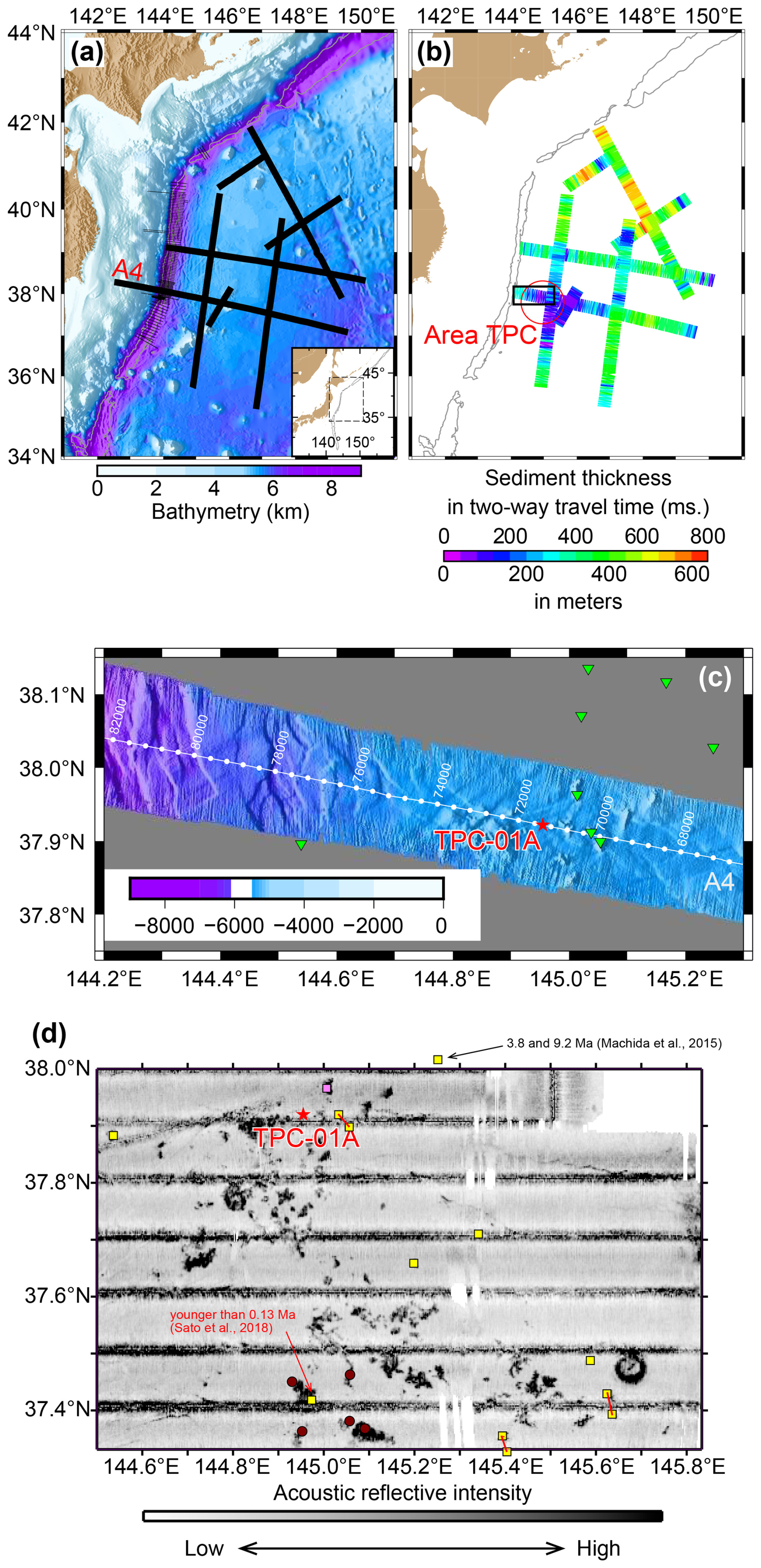
Figure 1Map of the study area. (A) Bathymetric map of the NW Pacific with seismic survey lines (black lines), including line A4, and (B) map showing variations in thickness of sediment above the acoustic basement in the area (modified from Fujie et al., 2020). The two-way travel time (in milliseconds) corresponding to the sediment layer is derived from multi-channel seismic reflection profiles, and the layer thickness (in metres) is estimated from the constant P-wave velocity of 1.6 km s−1. (C) Detailed bathymetric map along seismic survey line A4, obtained using a multi-narrow beam echo sounder during the seismic survey (modified from Fujie et al., 2020). Green triangles show previous dive sites of the human-occupied submersible (HOV) Shinkai-6500. Proposed Site TPC-01A is our primary drilling site. There are several small knolls around TPC-01A, suggesting the presence of petit-spot volcanoes. Based on this rough seafloor topography, Hirano (2011) suggested that there are more than 80 petit-spot volcanoes in this area. This is corroborated by the recent volcanic activity in this area. (D) Backscatter map covering Proposed Site TPC-01A, modified from Hirano et al. (2008). Yellow squares, a pink square, and brown circles indicate HOV Shinkai-6500 dive sites during the YK14-05 cruise, an ROV (remotely operated vehicle) Kaiko-7000 dive site during Kairei cruise KR07-07, and dredge sites from Shinsei-Maru cruise KS18-09, respectively. The youngest and most strongly alkaline lavas were recovered from the sites located south of TPC-01A (younger than 0.13 Ma; Sato et al., 2018), whereas two older eruption ages of 3.8 and 9.2 Ma were reported at the sites located northeast of TPC-01A (Machida et al., 2015).
We hypothesise that the thin acoustic layer is formed because the originally thicker pelagic sediment layer was disturbed and metamorphosed due to the intrusion of basaltic sills or the eruption of sheet lavas within and/or above it and that the intrusive and extrusive events were fed by petit-spot volcanism that occurred around the outer rise (Fig. 2). Petit-spots are a recently discovered volcanic system characterised by highly alkalic and CO2-rich basalt that is generated by a low degree of partial melting of the asthenosphere. These deep mantle melts have been proposed to form and upwell due to the flexure of the oceanic Pacific Plate aged 120–130 Myr prior to subduction (Hirano et al., 2006; Yamamoto et al., 2014; Machida et al., 2015, 2017). This magmatism creates a volcanic cluster composed of tiny monogenetic basalt volcanoes that are a few kilometres in diameter and less than 300 m high. Considering the wide distribution of the acoustic thin sediment cover in this region (Fig. 1), we may have vastly underestimated the volume of petit-spot magmatism. If this is the case, then petit-spot rocks are much more widely distributed than has been previously thought.
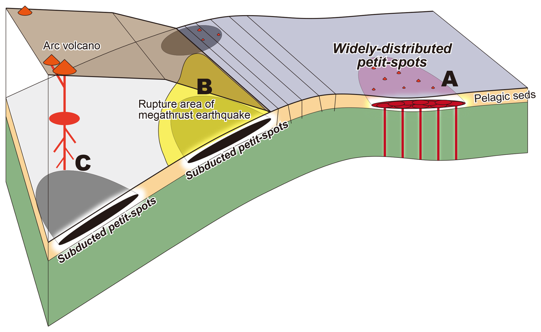
Figure 2Petit-spots, subduction megathrust earthquakes, and global geochemical cycles. Schematic illustration showing the relationships between widely distributed petit-spots, subduction megathrust earthquakes, and global geochemical cycles. Widely distributed petit-spots may affect (A) the global carbon cycle, (B) subduction zone earthquakes (i.e. by rupturing nucleation at depths and/or inhibiting slip propagation along the shallow part of the subduction megathrust), and (C) subduction zone geochemical cycles.
1.1 The impact of petit-spots on subduction zone earthquakes
The thickness of the sedimentary package of an incoming plate affects the rupture dynamics of the plate boundary megathrust earthquakes. Variations in sediment thickness in the Japan Trench suggest that a thick sediment layer is likely to reduce interplate coupling (Tsuru et al., 2002). The hypocentre of the 2011 Tohoku earthquake corresponds to the high-seismic-velocity section of the plate boundary, potentially related to thin incoming sediment (Huang and Zhao, 2013). On the other hand, the existence of frictionally weak material in the plate boundary also affects coseismic slip propagation. The shallow tsunamigenic slip during the 2011 Tohoku earthquake was caused by a smectite-rich pelagic clay layer with low coseismic friction (Ujiie et al., 2013). Although this pelagic clay layer was deposited in the Miocene and is broadly distributed in the NW Pacific (Kameda et al., 2015; Moore et al., 2015), if such a layer were to be intruded upon or covered by the widely distributed petit-spot basalt sills or extrusive lavas, the clays would have been thermally metamorphosed or dismembered, leading to the apparent acoustically thin sediment layer (Fujie et al., 2020; Akizawa et al., 2022). Either the phase transition of clay mineral or the lack of a clay layer would lead to changes in the frictional properties of a plate boundary fault. Therefore, in either situation, subducted petit-spots could influence plate boundary earthquakes; they could potentially activate the nucleation of fault rupture at depth and also potentially inhibit slip propagation at shallow levels.
1.2 The impact of petit-spots on geochemical cycles
Understanding the extent of magmatism and the geochemical nature of widely distributed petit-spot basalts is potentially significant to Earth's geochemical cycles. Currently, it is generally assumed that there are only small volumes of these features, but, if more abundant, the contribution of the petit-spots to global geochemical cycles could be greatly underestimated. Petit-spot lavas are strongly alkalic and have a high carbon dioxide (CO2) content; the estimated CO2 flux at various petit-spots is higher than that observed in hotspot volcanism (Okumura and Hirano, 2013). If the total volume of petit-spot magmatism is larger than previously thought then it could be an important pathway for CO2 outgassing from the mantle that influences the global carbon cycle.
The isotopic signatures of petit-spot basalts are of the enriched-mantle-1 (EM1) type in terms of Sr–Nd–Hf–Pb isotopes (Fig. 3) (Machida et al., 2009; Miyazaki et al., 2015). This chemistry differs from that for any other Pacific Plate components subducted beneath NW Japan. If widely distributed petit-spots had been active in the past then the EM1 geochemical component could be recycled into present-day arc magmas. Identification of widely distributed petit-spots would then require a reassessment of the subduction zone geochemical cycle.
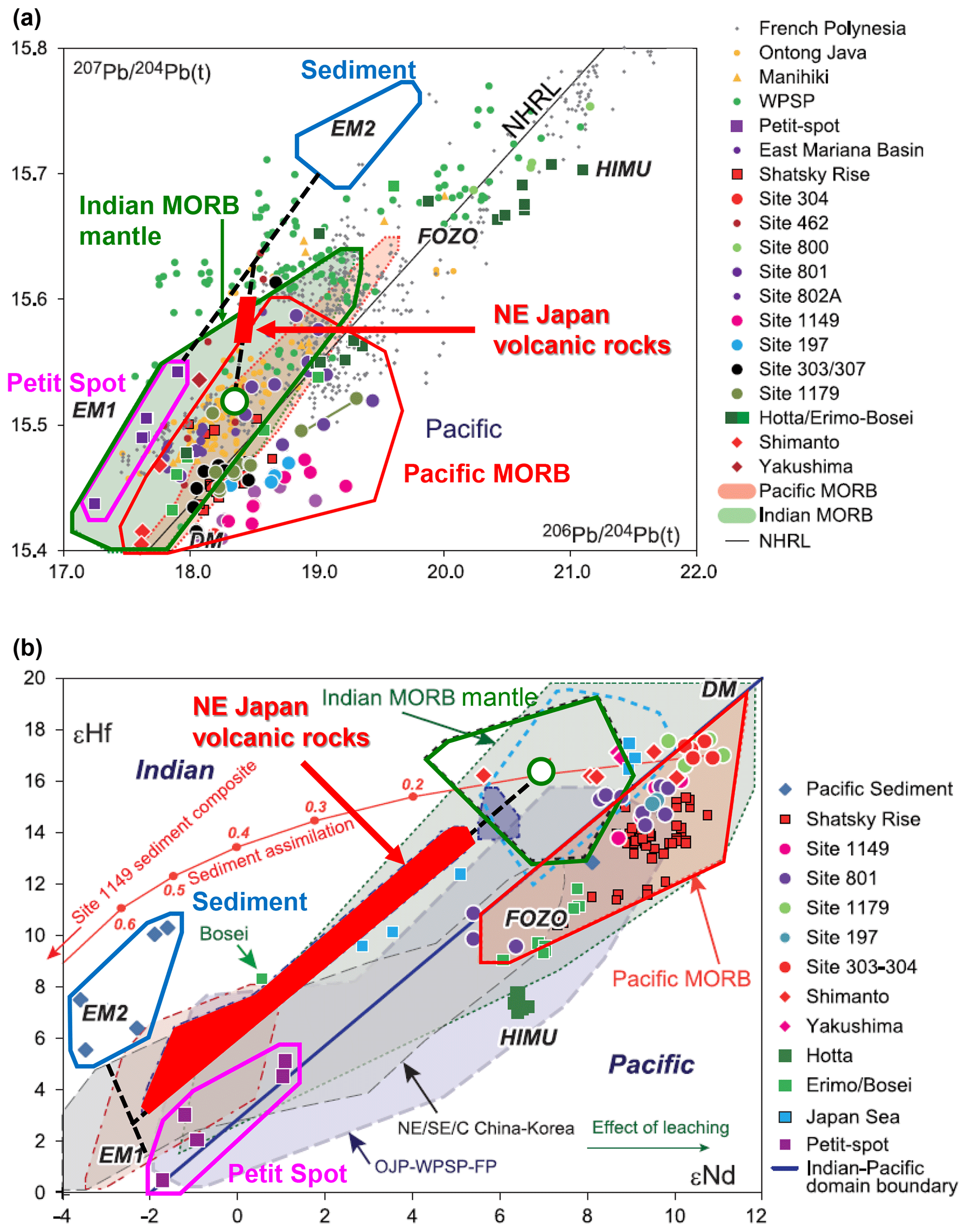
Figure 3Nd–Hf–Pb geochemistry of volcanic rocks from petit-spots and NE Japan compared with Pacific Mid-Ocean Ridge Basalt (MORB), Indian MORB mantles, sediments, and volcanic rocks in the Pacific Ocean (Miyazaki et al., 2015). (a) Time-corrected Pb isotopic competitions. The corrections were made based on their respective initial values. (b) εNd–εHf compositions. The isotopic variation in NE Japan volcanic rocks (red area) can be explained by mixing the components of petit-spot-derived volcanic rock, Indian MORB, and sediment, as shown by the thick dashed lines. This indicates that significant amounts of petit-spot materials can be transported into the Earth's deep interior as the oceanic plate subducts beneath NE Japan.
The International Ocean Drilling Programme (IODP3) Expedition 502 plans to explore the nature of the acoustic basement in the outer-rise area of the NW Pacific subduction system, where layer-1 pelagic sediment of the subducting old (120–130 Ma) Pacific Plate is exceptionally thin (< 100 m). The hypothesis is that the acoustically thin sediment cover can be attributed to basalt sill intrusions or extrusive sheet lavas into and on the pelagic sediment package, as well as associated metamorphism and thermal dismembering, fed by petit-spot magmatism. This hypothesis is supported by studies of seismic reflection (Fujie et al., 2020) and dive surveys (Akizawa et al., 2022) but will be tested through drilling to see if petit-spot magmatism at the outer rise is more widely distributed than previously thought. Testing this hypothesis will shed light on the impacts of subduction inputs and help to determine the global role of petit-spot magmatism, both of which are aligned with the 2050 science framework of scientific ocean drilling, specifically the strategic objectives of the Oceanic Life Cycle of Tectonic Plate and the Natural Hazards Impacting Society, as well as a flagship initiative of Assessing Earthquake and Tsunami hazards (Koppers and Coggon, 2020).
Petit-spot magmatism
Volcanism on the Earth had been believed to occur in three tectonic settings: divergent plate boundaries (such as rifts and mid-ocean ridges), convergent plate boundaries (such as island arcs), and hotspots. However, clusters of small alkalic volcanoes on the Pacific Plate – aged ∼ 135 Myr – not conforming to any of these categories were discovered in the early 21st century, and, due to their small sizes, were termed “petit-spot volcanoes” (Hirano et al., 2006). After their first discovery in the Japan Trench, petit-spot volcanoes have been found off Java, Chile, and the Mariana Trench (Hirano and Machida, 2022). Petit-spots are thought to form in response to the flexural bending of an oceanic plate as it approaches a subduction zone and provide a unique opportunity to examine the structure, geochemical composition, and carbon cycle of the lithospheric and asthenospheric mantle beneath the subducting oceanic crust (Machida et al., 2017; Hirano and Machida, 2022). Petit-spot magmatism creates volcanic clusters composed of monogenetic basalt volcanoes, typically with diameters of a few kilometres and heights of less than 300 m (Hirano et al., 2006). These are similar to subaerial intraplate volcanic fields (Valentine and Hirano, 2010) that can produce widespread lava flows and shallow sills (Valentine and Krogh, 2006; Richardson et al., 2015).
The goal of this project is to investigate the existence of widely distributed petit-spot volcanism that may significantly impact the generation of megathrust earthquakes and the Earth's geochemical cycles. Only ocean drilling can assess the nature of the acoustic basement beneath regions of anomalously thin sediment cover through downhole logging, as well as sampling of the sediments, rocks, void gases, and pore fluids that may contain volatile elements with isotopic signals of a deep mantle source.
3.1 Nature of the acoustic basement in regions of thin sediment cover
If the acoustic basement consists of extrusive rocks then lavas or volcanic breccias will be sampled. In the case of intrusive rocks, fragments of thermally affected sediment will also be recovered. Particular attention will be paid to any thermal alteration of the sediments at the upper contact as such features would be indicative of a hot sill intrusion.
3.2 Impact of petit-spots on composition of pelagic sediments
We will determine the ages of all recovered sediments using magnetostratigraphy, tephrochronology, and biostratigraphy. If Miocene smectite-rich pelagic clay is thin or absent from the thin sediment cover, it could inhibit coseismic slip propagation at shallow depths yet also facilitate rupture nucleation at seismogenic depths, with a significant impact on megathrust earthquake segmentation.
3.3 Geochemical estimation of fluxes related to petit-spot volcanism
Analyses of basalt and altered sediment samples will characterise the geochemical signature of this petit-spot magmatism and allow us to better assess its influence on subduction zone magmatism. Age dating is also important for estimating the total flux of petit-spot magmatism. Volatile contents in the basalts and adjacent sediments, along with the isotope geochemistry of gases and pore waters, will be used to determine the nature of volatiles released at the outer rise.
IODP3 Expedition 502 proposes drilling at one main site (TPC-01A) on the incoming plate adjacent to the region of largest slip during the 2011 Tohoku earthquake (Fig. 1). Figure 4 shows seismic reflection profiles of all of the proposed drilling sites. Seismic reflection line A4 is located in the outer-rise region of the central Japan Trench; the eastern half of the profile crosses Area TPC. The first strong reflector beneath the seafloor (acoustic basement) has significantly rough topography. Proposed Site TPC-01A is located in an area where the sediment cover is thin.
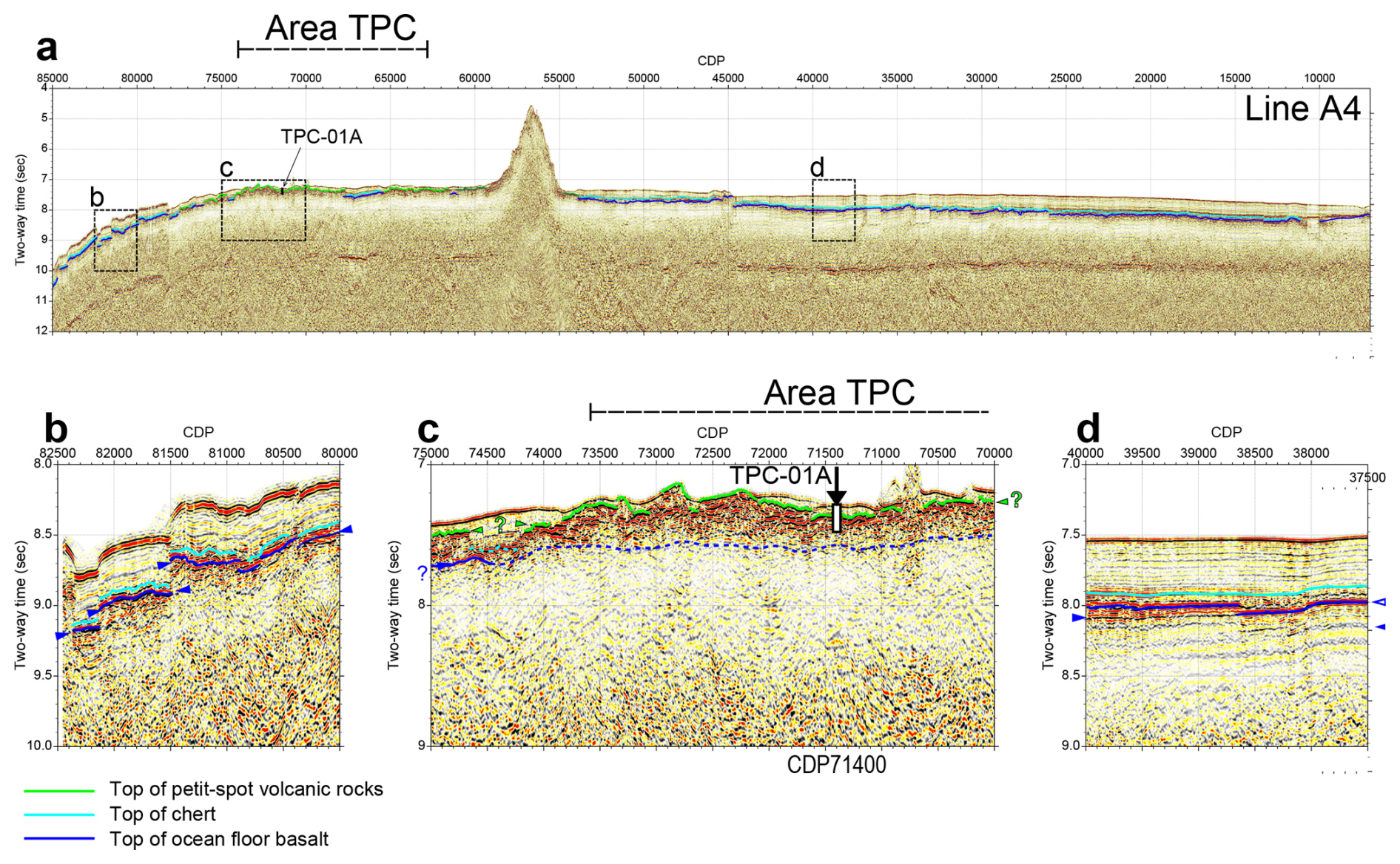
Figure 4Time-migrated seismic reflection profiles of (a) line A4 and (b–d) zoomed-in regions, showing the proposed drill site TPC-01A (modified from Fujie et al., 2020). Dark-blue, light-blue, and light-green interpretation lines in each figure indicate the top of the ocean floor basalt, the top of the chert, and the top of petit-spot volcanic rocks, respectively. Seismic reflection line A4 is located in the outer-rise region of the central Japan Trench; the eastern half of the profile crosses Area TPC (Fig. 1a and b). Reflectors corresponding to chert and ocean floor basalt are well observed on both sides of Area TPC (Fig. 4b and d), whereas, from CDP59000 to CDP78000, the first strong reflector beneath the seafloor (acoustic basement) has significantly rough topography and is shallower than those in other portions and is interpreted as buried petit-spot basalt (c).
Site survey data
All site survey data for Expedition 502, such as bathymetric data, are available at JAMSTEC (2004). Table 1 and Fig. 5 depict the site summary for Proposed Site TPC-01A.
Table 1Site summary. TD: total depth; m b.s.f.: metres below seafloor.
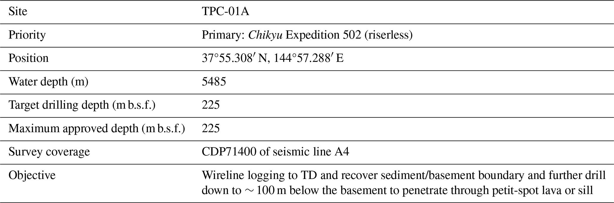
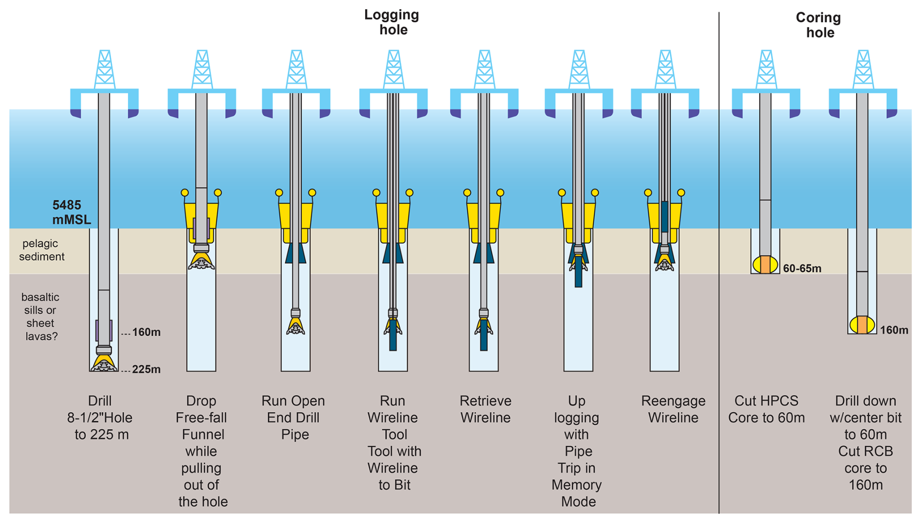
Figure 5Proposed operation plan for IODP3 Expedition 502. The first logging borehole will be drilled to total depth (TD) (ca. 225 m b.s.f.), and then, before pulling out of the hole, a free-fall funnel will be dropped to allow for borehole re-entry. An open drill pipe will be run into the borehole, and then the ThruBit wireline logging (WL) tools will be run through the open pipe to log the open borehole. Once WL is complete, the logging data will be used to identify the coring targets for the coring borehole, where coring by a hydraulic piston coring system (HPCS) and an extended shoe coring system (ESCS) and by a rotary core barrel (RCB) will be performed. The most prioritised target in this project is to recover the sediment or basement contact and determine the thickness of the intrusive or extrusive body. Logging (gamma-ray, resistivity, sonic velocity) will help determine the exact depth of the acoustic basement and the thickness of volcanic rocks. The light-brown layer corresponds to the sediment layer, and the dark-brown layer corresponds to basaltic sills or sheet lavas. An example scenario of the boundary depth (60–65 m) is used in this figure. The exact depth for the boundary – and, thus, the depth at which coring is switched from HPCS or ESCS to RCB coding – will be determined and updated through drilling and wireline logging operations.
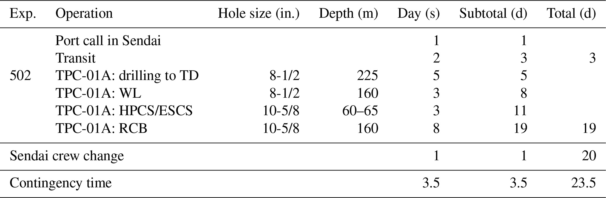
Operations will begin after a short port call in Sendai, Japan, where the Expedition 502 Science Team will embark, before transiting to the drill site. IODP3 Expedition 502 will visit Proposed Site TPC-01A. The general operation plan and time estimates are provided in Table 2 and Fig. 5. The operational sequence to be completed by D/V Chikyu during IODP3 Expedition 502 will penetrate through the acoustic basement at ∼ 60 m below the sea floor (m b.s.f.) and then drill down an additional 165 m, down to ∼ 225 m b.s.f. (Fig. 5). The drilling depth of 225 m includes the target logging and coring depth of 160 m plus an additional depth to compensate for the length of the wireline logging (WL) tools and a 20 m rat hole. The target logging and coring depths have been chosen because a single-channel seismic reflection study shows that the petit-spot lavas are likely to have a thickness of < 100 m (Fujiwara et al., 2007). The estimated time for the entire operation is 24 d, determined by MarE3/JAMSTEC.
5.1 Wireline logging
The IODP3 Expedition 502 drilling operation will begin with drilling an 8.5 in. hole to ca. 225 m b.s.f. After installing a free-fall funnel onto the open borehole, wireline logging (WL) will be used to clarify the geophysical and geological nature of the basement, as well as the exact depths of the boundaries. WL tools will be run through the centre of an open-ended drill pipe and will comprise the following suite of Schlumberger ThruBit WL tools: Telemetry Memory Gamma-ray (TMG), Laterolog (resistivity [TBLA]), Dipole Sonic (TBDS), and the Electronic Imager (TBEI). Clear changes in gamma-ray, resistivity, and sonic velocity are expected at the sediment or basaltic basement contact from WL data.
5.2 Coring
The next phase of operations will comprise coring the entire depth range with the hydraulic piston coring system (HPCS) or the extended shoe coring system (ESCS) for sediments and the small-diameter rotary core barrel (SD-RCB) for the basement.
A Sampling and Measurements Plan (SMP) for Expedition 502 has been prepared by MarE3 and the Co-Chief Scientists to meet the scientific objectives of IODP3 Expedition 502. Science activities on the D/V Chikyu during the expedition will apply standard IODP3 shipboard curation, measurements, and publications. Details of the facilities that will be available can be found on the Chikyu wikipages. The Measurements Plan will take account of Chikyu specifications for quality assurance and quality control (QA/QC). The following briefly summarises the shipboard scientific activities:
-
logging and core–log–seismic integration (CLSI) (gamma-ray, resistivity, and sonic velocity logs and their depth distribution) – comparing and integrating logging results with core and seismic results;
-
sedimentology – non-destructive visual core description and smear slide observation, high-resolution digital imaging, X-ray computed tomography (X-CT) scans, colour reflectance spectrophotometry, bulk mineralogy with X-ray diffraction (XRD), bulk chemistry with X-ray fluorescence (XRF), particle size analysis, and tephrochronology;
-
igneous petrology – visual core description, thin section observation, high-resolution digital imaging, X-CT scans, bulk mineralogy with XRD, and bulk chemistry with XRF (including metamorphic or hydrothermal petrological investigations along the contact);
-
structural geology – visual core description, fault and fracture orientation analysis, X-CT scans, and detail microstructure of lithological boundaries;
-
micropaleontology – biostratigraphic analyses of siliceous microfossils (e.g. diatom and radiolaria), benthic foraminifers, and redeposited calcareous pelagic microfossils and nannofossils;
-
paleomagnetism – paleomagnetic measurements and magnetostratigraphy, magnetic susceptibility;
-
physical properties – multi-sensor core logging for gamma density, P-wave velocity, electrical resistivity, natural gamma radiation, thermal conductivity measurement, P-wave velocity, and moisture and density (MAD) on discrete samples, as well as undrained shear strength and unconfined compressive strength;
-
geochemistry – taking samples for headspace (HS) shipboard gas analyses of concentrations and relative abundance of light hydrocarbon gases (C1 to C4) and noble gases, pore fluid chemistry (by Rhizon and squeezed samples), carbon–hydrogen–nitrogen–sulfur (CHNS) elemental analysis, and sediment organic or inorganic carbon analyses;
-
taking and proper storage (+4 and −80 °C) of samples for microbiological post-expedition research and for ephemeral properties.
In principle, the report preparation will take place on board as required; the reports to be compiled include the following:
-
Daily and weekly operational reports will be compiled by MarE3 and provided to the management and panels of IODP3, as well as any other relevant parties. Scientific reports are provided by the Co-Chief Scientists.
-
An Expedition Summary will be compiled by the Science Team (submission to IODP3 publications at the end of the expedition).
-
The Methods and Site Reports will be compiled by the Science Team (and will be submitted to IODP3 publications as soon as practically possible after the expedition).
All researchers requesting samples should refer to the IODP3 Sample, Data, and Obligations Policy & Implementation Guidelines (https://iodp3.org/documents/sample-data-obligations-policy/, last access: 4 January 2026). This document outlines the policy for distributing IODP3 samples and data to research scientists, curators, and educators. The document also defines the obligations that sample and data recipients incur. The Sample Allocation Committee (SAC; composed of Co-Chief Scientists, Expedition Project Manager, and IODP3 Curator) will work with the entire Science Team to formulate an expedition-specific sampling plan for shipboard (expedition) and post-cruise (personal post-expedition research) sampling.
Members of the Science Team are expected to carry out scientific research for the expedition and to publish results. Before the expedition, all members of the Science Party are required to submit research plans and associated sample or data requests via the IODP3 Sample, Data, and Research Request (SDRM) system (https://web.iodp.tamu.edu/SDRM/#/, last access: 4 January 2026) about 6 months before the beginning of the expedition. Based on sample and/or data requests submitted by this deadline, the SAC will prepare a tentative sampling plan, which will be revised on the ship once cores are collected and split as dictated by recovery and cruise objectives. All post-cruise research projects should provide scientific justification for the desired sample size, numbers, and frequency. The sampling plan will be subject to modification depending upon the material recovered and collaborations that may evolve between scientists during the expedition. This planning process is necessary to coordinate the research to be conducted and to ensure that the scientific objectives are achieved. Modifications to the sampling plan and access to samples and data during the expedition and during the 1-year post-expedition moratorium period require the approval of the SAC.
The permanent archive halves are officially designated by the IODP3 curator. Should there be a copy of an interval from parallel holes, they may be classified as temporary archives. All sample frequencies and volumes must be justified on a scientific basis and will depend on core recovery, the full spectrum of other requests, and the expedition objectives. Some redundancy of measurement is unavoidable, but minimising the duplication of measurements among the shipboard team and identified shore-based collaborators will be a factor in evaluating sample requests.
If critical intervals are recovered, there may be considerable demand for samples from a limited amount of cored material. A sampling plan coordinated by the SAC will be required before critical intervals are sampled. The SAC strongly encourages and may require collaboration and/or sharing among the shipboard and shore-based scientists so that the best use is made of the recovered core. Coordination of post-cruise analytical programmes is anticipated to ensure that the full range of geochemical, isotopic, and physical property studies are undertaken on a representative sample suite.
The data management plan follows the standard Chikyu and IODP3 measurement policies.
-
Core sections will be registered in J-CORES, the Chikyu Lab Management System, along with all personal samples, subsamples, data, images, and standard shipboard measurements. At the end of the expedition, the data will be archived in the web-browser-accessible JAMSTEC Scientific Ocean Drilling Data (J-SODD) database.
-
Core sections (archive and working halves) will be stored at an IODP3 core repository to be determined.
-
Shipboard data will be available in the JAMSTEC Scientific Ocean Drilling Data (J-SODD).
JAMSTEC/MarE3, the PMO offices, and IODP3 will collaborate on outreach activities before, during, and after the expedition.
Scientific staffing is determined on the basis of task requirements and nominations from the IODP3 Programme Member and Associate Member Offices. Staffing is based on the need to carry out the drilling and scientific operations safely and efficiently. A list of participants for Expedition 502 will be added to the JAMSTEC Chikyu Expedition 502 website when available (https://www.jamstec.go.jp/chikyu/e/exp502, last access: 4 January 2026).
Data are available at https://web.iodp.tamu.edu/SDRM (International Ocean Discovery Program, 2026a), https://ssdb.iodp/org/ (International Ocean Drilling Programme, 2026b), https://iodp3.org/documents/sample-data-obligations-policy/ (International Ocean Drilling Programme, 2024), and https://www.jamstec.go.jp/e/about/equipment/ships/chikyu.html (Japan Agency for Marine-Earth Science and Technology, 2026).
AY, HK, and NO developed the scientific objectives and operational plan of the IODP3 Expedition 502. AY prepared the paper with contributions from all of the co-authors.
The contact author has declared that none of the authors has any competing interests.
The authors thank the proponents of the drilling proposal 939APL (Gou Fujie, Naoto Hirano, Takanori Kagoshima, Norikatsu Akizawa, Jun-Ichi Kimura, Cecilia McHugh, Jason Morgan, Tomoaki Morishita, Yasuyuki Nakamura, Shigeaki Ono, Sébastien Pilet, Susanne Straub, Tomohiro Toki, Yama Tomonaga, Greg Valentine, and Makoto Yamano).
Publisher’s note: Copernicus Publications remains neutral with regard to jurisdictional claims made in the text, published maps, institutional affiliations, or any other geographical representation in this paper. While Copernicus Publications makes every effort to include appropriate place names, the final responsibility lies with the authors. Views expressed in the text are those of the authors and do not necessarily reflect the views of the publisher.
This paper was edited by Thomas Belgrano and reviewed by Jörg Geldmacher and Damon Teagle.
Akizawa, N., Hirano, N., Machida, S., Tamura, C., Kaneko, J., Iwano, H., Danhara, T., and Hirata, T.: A direct evidence for disturbance of whole sediment layer in the subducting Pacific plate by petit-spot magma–water/sediment interaction, Mar. Geol., 444, 106712, https://doi.org/10.1016/j.margeo.2021.106712, 2022.
Fujie, G., Kodaira, S., Nakamura, Y., Morgan, J. P., Dannowski, A., Thorwart, M., Grevemeyer, I., and Miura, S.: Spatial variations of incoming sediments at the northeastern Japan arc and their implications for megathrust earthquakes, Geology, 48, 614–619, https://doi.org/10.1130/G46757.1, 2020.
Fujiwara, T., Hirano, N., Abe, N., and Takizawa, K.: Subsurface structure of the “petit-spot” volcanoes on the northwestern Pacific Plate, Geophys. Res. Lett., 34, L13305, https://doi.org/10.1029/2007GL030439, 2007.
Hirano, N.: Petit-spot volcanism: a new type of volcanic zone discovered near a trench, Geochem. J., 45, 157–167, https://doi.org/10.2343/geochemj.1.0111, 2011.
Hirano, N. and Machida, S.: The mantle structure below petit-spot volcanoes, Nat. Commun., 3, 110, https://doi.org/10.1038/s43247-022-00438-1, 2022.
Hirano, N., Takahashi, E., Yamamoto, J., Abe, N., Ingle, S. P., Kaneoka, I., Hirata, T., Kimura, J., Ishii, T., Ogawa, Y., Machida, S., and Suyehiro, K.: Volcanism in Response to Plate Flexure, Science, 313, 1426–1428, https://doi.org/10.1126/science.1128235, 2006.
Hirano, N., Koppers, A. A. P., Takahashi, A., Fujiwara, T., and Nakanishi, M.: Seamounts, knolls and petit-spot monogenetic volcanoes on the subducting Pacific Plate, Basin Res., 20, 543–553, https://doi.org/10.1111/j.1365-2117.2008.00363.x, 2008.
Huang, Z. and Zhao, D.: Mechanism of the 2011 Tohoku-oki earthquake (Mw 9.0) and tsunami: Insight from seismic tomography, J. Asian Earth Sci., 70–71, 160–168, https://doi.org/10.1016/j.jseaes.2013.03.010, 2013.
International Ocean Discovery Program: IODP Sample, Data, and Research Request Manager, https://web.iodp.tamu.edu/SDRM/#, last access: 4 January 2026a.
International Ocean Drilling Programme: Scientific Ocean Drilling Programs Sample, Data, and Obligations Policy, https://iodp3.org/documents/sample-data-obligations-policy/ (last access: 4 January 2026), 2024.
JAMSTEC: JAMSTEC Seismic Survey Datbase, JAMSTEC, https://doi.org/10.17596/0002069, 2004.
Kameda, J., Shimizu, M., Ujiie, K., Hirose, T., Ikari, M., Mori, J., Oohashi, K., and Kimura, G.: Pelagic smectite as an important factor in tsunamigenic slip along the Japan Trench, Geology, 43, 155–158, https://doi.org/10.1130/G35948.1, 2015.
Koppers, A. P. and Coggon, R.: Exploring Earth by scientific ocean drilling: 2050 science framework, University of California, San Diego, 124 pp., https://doi.org/10.6075/J0W66J9H, 2020.
Machida, S., Hirano, N., and Kimura, J.-I.: Evidence for recycled plate material in Pacific upper mantle unrelated to plumes, Geochim. Cosmochim. Ac., 73, 3028–3037, https://doi.org/10.1016/j.gca.2009.01.026, 2009.
Machida, S., Hirano, N., Sumino, H., Hirata, T., Yoneda, S., and Kato, Y.: Petit-spot geology reveals melts in upper-most asthenosphere dragged by lithosphere, Earth Planet. Sc. Lett., 426, 267–279, https://doi.org/10.1016/j.epsl.2015.06.018, 2015.
Machida, S., Kogiso, T., and Hirano, N.: Petit-spot as definitive evidence for partial melting in the asthenosphere caused by CO2, Nat. Commun., 8, 14302, https://doi.org/10.1038/ncomms14302, 2017.
Miyazaki, T., Kimura, J., Senda, R, Vaglarov, B.S., Chang, Q., Takahashi, T., Hirahara, Y., Hauff, F., Hayasaka, Y., Sano, S., Shimoda, G., Ishizuka, O., Kawabata, H., Hirano, N., Machida, S., Ishii, T., Tani, K., and Yoshida, T.: Missing western half of the Pacific Plate: Geochemical nature of the lzanagi-Pacific Ridge interaction with a stationary boundary between the Indian and Pacific mantles, Geochem. Geophy. Geosy., 16, 3309–3332, https://doi.org/10.1002/2015GC005911, 2015.
Moore, J. C., Plank, T. A., Chester, F. M., Polissar, P. J., and Savage, H. M.: Sediment provenance and controls on slip propagation: Lessons learned from the 2011 Tohoku and other great earthquakes of the subducting northwest Pacific plate, Geosphere, 11, 533–541, https://doi.org/10.1130/GES01099.1, 2015.
Okumura, S. and Hirano, N.: Carbon dioxide emission to Earth's surface by deep-sea volcanism, Geology, 41, 1167–1170, https://doi.org/10.1130/G34620.1, 2013.
Richardson, J. A., Connor, C. B., Wetmore, P. H., Connor, L. J., and Gallant, E. A.: Role of sills in the development of volcanic fields: Insights from lidar mapping surveys of the San Rafael Swell, Utah, Geology, 43, 1023–1026, https://doi.org/10.1130/G37094.1, 2015.
Sato, Y., Hirano, N., Machida, S., Yamamoto, J., Nakanishi, M., Ishii, T., Taki, A., Yasukawa, K., and Kato, Y.: Direct ascent to the surface of asthenospheric magma in a region of convex lithospheric flexure, Int. Geol. Rev., 60, 1231–1243, https://doi.org/10.1080/00206814.2017.1379912, 2018.
Tsuru, T., Park, J., Miura, S., Kodaira, S., Kido, Y., and Hayashi, T.: Along-arc structural variation of the plate boundary at the Japan Trench margin: Implication of interplate coupling, J. Geophys. Res., 107, 2357, https://doi.org/10.1029/2001JB001664, 2002.
Ujiie, K., Tanaka, H., Saito, T., Tsutsumi, A., Mori, J.J., Kameda, J., Brodsky, E. E., Chester, F. M., Eguchi, N., Toczko, S., and Expedition 343 and 343T Scientists: Low Coseismic Shear Stress on the Tohoku-Oki Megathrust Determined from Laboratory Experiments, Science, 342, 1211–1214, https://doi.org/10.1126/science.1243485, 2013.
Valentine, G. A. and Hirano, N.: Mechanisms of low-flux intraplate volcanic fields – Basin and Range (North America) and northwest Pacific Ocean, Geology, 38, 55–58, https://doi.org/10.1130/G30427.1, 2010.
Valentine, G. A. and Krogh, K. E. C.: Emplacement of shallow dikes and sills beneath a small basaltic volcanic center: The role of pre-existing structure (Paiute Ridge, southern Nevada, USA), Earth Planet. Sc. Lett., 246, 217–230, https://doi.org/10.1016/j.epsl.2006.04.031, 2006.
Yamaguchi, A., Nakamura, Y., Fukuchi, R., Kurano, H., Ikehara, K., Kanamatsu, T., Arai, K., Usami, K., and Ashi, J.: Heterogeneous distribution of pelagic sediments incoming the Japan Trench possibly controlling slip propagation on shallow plate boundary fault, AGU Fall Meeting, 11–15 December, abstract T14B-06, 2017.
Yamamoto, J., Korenaga, J., Hirano, N., and Kagi, H.: Melt-rich lithosphere-asthenosphere boundary inferred from petit-spot volcanoes, Geology, 42, 967–970, https://doi.org/10.1130/G35944.1, 2014.
- Abstract
- Schedule for Expedition 502
- Introduction
- Background
- Scientific objectives
- Site characterisation
- Operation plan and coring strategy
- Science operations
- Research planning: sampling and data-sharing strategy
- Core and data management
- Outreach
- Staffing
- Data availability
- Author contributions
- Competing interests
- Acknowledgements
- Disclaimer
- Review statement
- References