the Creative Commons Attribution 4.0 License.
the Creative Commons Attribution 4.0 License.
 | 29 Apr 2026
IODP3 Expedition 504S “Volcanic ash on the Ontong Java Plateau: testing models of subduction reversal and wind transport in the western equatorial Pacific” Scientific Prospectus
Robert John Musgrave
Ann Dunlea
IODP3 Expedition 504S will re-examine legacy cores of the Deep Sea Drilling Project (DSDP) and Ocean Drilling Program (ODP) drilled on the Ontong Java Plateau (OJP). Positioned in the western equatorial Pacific, the OJP is the world's largest oceanic plateau and is flanked by island arc and hotspot volcanoes. Since at least the Eocene, eruptions have deposited volcanic ash throughout the marine sediment, accumulating on the OJP. This expedition will focus on the provenance, history, and evolution of the volcanic ash record to achieve two principal objectives: (1) pinpoint the timing and mechanism of the subduction reversal resulting from collision of the OJP with the Solomon Islands arc and (2) reconstruct wind patterns and the deposition of dust and volcanic ash in the western equatorial Pacific since the Eocene. Collision of the OJP with the arc is thought to have congested the subduction zone and caused subduction reversal. Despite being regarded as the prototypical example of this process, there are three incompatible hypotheses for the timing and mechanism of the collision and subduction reversal. One widely accepted hypothesis involves “soft docking”, a concept involving an initial collision that halts subduction but is not marked by local deformation. Soft docking has been invoked in other collisional settings and locally as the cause of a change in Australian plate motion. The determination of whether the OJP ashes are arc- or hotspot derived will differentiate between the tectonic hypotheses, testing the validity of soft docking. The expedition will fingerprint the origin of volcanic ashes and establish a chronology of eruption history. We will characterise both ash deposited in layers and ash dispersed throughout the bulk sediment separately from aeolian dust derived from continental crust for a comprehensive perspective on ash and aeolian dust deposited on the OJP. Legacy cores from the OJP have marine sediment archives that cover the late Eocene to the present, allowing for the reconstruction of aeolian deposition over million-year time scales. The expedition will test hypotheses of dust fluxes increasing from the strengthening of the monsoon systems and the migration of the inter-tropical convergence zone since the Eocene. Expedition 504S addresses strategic objectives of the 2050 Science Framework, including the oceanic life cycle of tectonic plates, natural hazards impacting society, feedbacks in the Earth system, and global cycles of energy and matter. Expedition 504S will operate in parallel with a shore-based study of volcaniclastic rocks from the Malaita Terrane, an accreted fragment of OJP-related crust.
- Article
(7677 KB) - Full-text XML
- BibTeX
- EndNote


The Ontong Java Plateau (OJP), located in the western equatorial Pacific (Fig. 1), is the largest oceanic plateau in the world (Mahoney, 1987). It has been the target of five scientific ocean drilling expeditions: the Deep Sea Drilling Project (DSDP) Legs 7, 30, and 89; and the Ocean Drilling Program (ODP) Legs 130 and 192. The objectives of Legs 7, 30, and 89 were to establish the age of ocean crust, plateau structure, and sediment stratigraphy. The relationship between oceanic plateau large igneous provinces (LIPs), mantle plumes, and rifting initiation was the focus of Leg 192 (Shipboard Scientific Party, 2001). Leg 130 addressed both the geochemistry of the Cretaceous igneous rocks and the palaeoceanographic record preserved in the Late Cretaceous to Quaternary carbonate sedimentary sequence (Berger et al., 1991). However, multiple scientific questions were not addressed by previous studies of DSDP/ODP/IODP cores from the OJP. For one, the timing and mechanism of the collision of the OJP with the Solomon Islands arc and the subsequent initiation of subduction at a new trench on the opposite side of the arc remain unresolved. While collision between the OJP and the Solomon Islands arc is considered the prototypical example of subduction initiation by subduction reversal (Stern and Gerya, 2018; Stern, 2004), there is no consensus concerning the timing and nature of the collision and subduction reversal. Moreover, a standard model (referred to as “soft docking”) for the collision was implicit in the interpretation that the sequence of volcanic ashes recovered in the carbonate sequence was sourced from volcanism in the Melanesian arc, with implications for the wind direction responsible for their transport (Krissek and Janecek, 1993; Kroenke et al., 1993). The possibility that the ashes were derived from other sources, including the Samoan hotspot, was not considered at the time. The focus on ash and dust provenance in the proposed project will address these gaps.
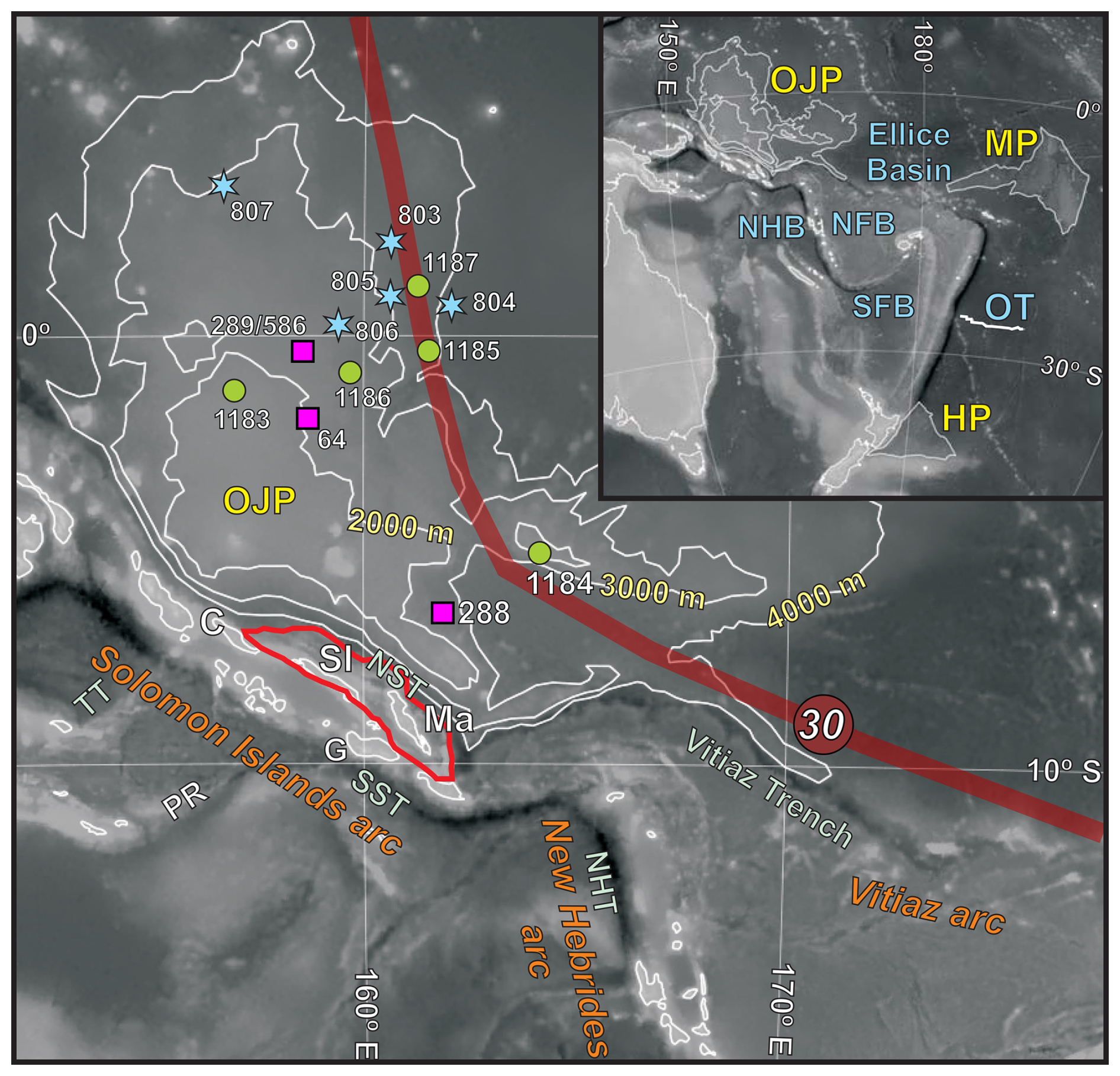
Figure 1Bathymetry of the Ontong Java Plateau (OJP) and legacy ocean drilling sites (pink squares = DSDP sites; blue stars = ODP Leg 130 sites; green circles = ODP Leg 192 sites). Inset shows elements of Ontong Java Nui and major back-arc basins. The thin red polygon indicates the extent of the Malaita Terrane. The transparent red band shows the approximate track of the Samoan hotspot predicted by Jackson et al. (2024), with approximate position for 30 Ma. MP = Manihiki Plateau; HP = Hikurangi Plateau; OT = Osbourn Trough; NFB = North Fiji Basin; SFB = South Fiji Basin; NHB = New Hebrides Basin; NHT = New Hebrides Trench; NST = North Solomons Trench; SST = South Solomons (San Cristobal) Trench; TT = Trobriand Trough; PR = Pocklington Ridge; C = Choiseul; SI = Santa Isabel; Ma = Malaita; G = Guadalcanal. Background map after Musgrave (2013).
Another area that received limited attention in previous studies is the abundance and origin of dispersed volcanic ash. In other regions, research on dispersed ash suggests that it could be a significant component of bulk marine sediment and potentially equal in magnitude to the amount of ash in the discrete layers (North Pacific, South Pacific, Caribbean; e.g. Peters et al., 2000; Scudder et al., 2016; Dunlea et al., 2015). In a tectonically active area like the OJP, there is certainly volcanic ash dispersed throughout the bulk sediment that has yet to be examined. A comparison of the dispersed ash versus the volcanic ash layers adds a dimension to the interpretation of the volcanic ash record. What is the magnitude of dispersed ash? Is the dispersed ash composition the same as the composition of the discrete ash layer? If so, it may indicate a period of less intense eruption before (or after) the main pulse of volcanism that created the discrete ash layer. If the dispersed and discrete ash compositions are different, it may suggest that a nearby volcano is creating discrete ash layers while a volcano farther away is supplying lesser amounts of ash that become mixed into the bulk sediment.
Separating and fingerprinting the dispersed ash is also essential to identifying the aeolian dust with which it is mixed. From the Eocene to Miocene, there were profound shifts in global aridity and wind patterns due to the onset and expansion of the global monsoon system, the uplift of the Himalayas, ice sheets in Antarctica, the migration of the inter-tropical convergence zone (ITCZ), and other major changes. Today, the OJP is positioned to receive wind-blown dust from multiple continents – making it a region particularly sensitive to global changes. Examining the aeolian history of the OJP will allow us to assess how the wind in the western equatorial Pacific was changing over major climatic and tectonic shifts.
Despite their potential significance for elucidating both the tectonics of the plateau and the palaeoclimate history of the western equatorial Pacific, the ashes have remained only lightly sampled, and no results or interpretations of their analysis have been reported. Expedition 504S will focus on these volcanic ashes, with the aim of testing hypotheses both on the nature, timing, and global significance of the OJP – Solomon Islands collision, and on the direction and strength of the winds transporting ash and dust to the plateau. This will be done by determining the provenance, age of deposition, sedimentology, and physical properties of the ash record in archived cores from the OJP. This study will run in parallel with an analysis of potentially correlative volcaniclastic rocks from an accreted part of the plateau which forms the Malaita Terrane of the Solomon Islands.
2.1 Ontong Java Plateau stratigraphy
Extremely voluminous basaltic volcanism emplaced most of the OJP in a relatively short-lived event in the Aptian (Tarduno et al., 1991); some volcanism may have persisted into the Albian (Berger et al., 1991). Volcaniclastic rocks encountered at the base of Site 1184, initially dated as Eocene (Shipboard Scientific Party, 2001), were later reassigned to the same Early Cretaceous event that produced the bulk of the OJP (Fitton et al., 2004). Further basaltic volcanism, dated ∼ 90 Ma, was drilled at Site 803 (Mahoney et al., 1993). Overlying the drilled igneous rocks (Fig. 2) is an Aptian to Holocene carbonate-dominated sequence, decreasing in lithification up-sequence from limestone through chalk to ooze, and reaching a total thickness of 1380 m at Site 807. Thin intervals of claystone occur at or near the base of the sedimentary sequence at Sites 803 and 807 (Berger et al., 1991).
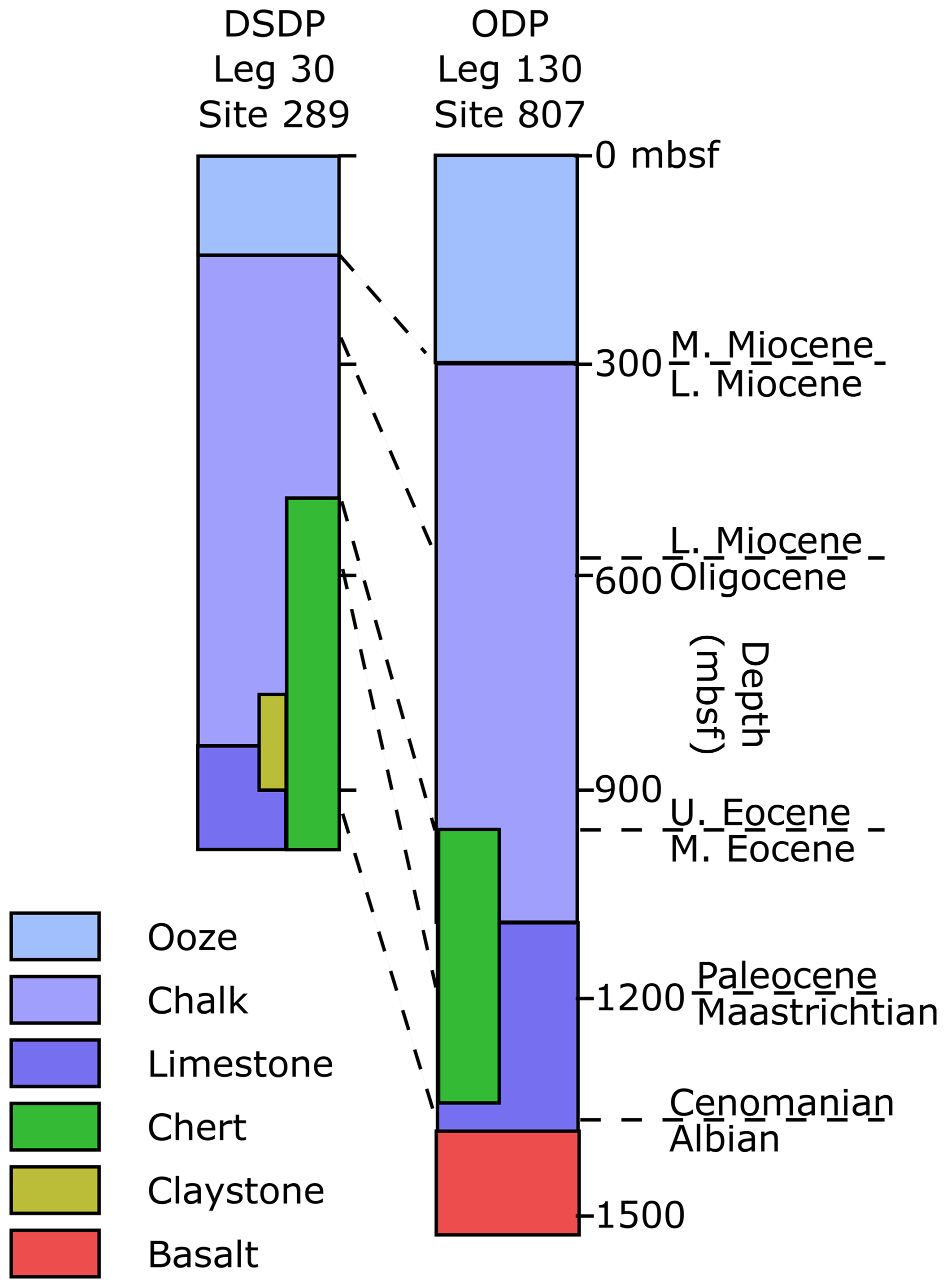
Figure 2Simplified stratigraphy of the OJP at two representative locations. Depth scale in metres below seafloor (mbsf). After Phinney et al. (1999).
Volcanic ashes – the focus of this expedition – are concentrated in three intervals: Palaeocene to early Eocene, late Eocene to Oligocene-earliest Miocene, and late Miocene to present. In total, the VOLCORE database (Mahony et al., 2020) collated 99 ash layers, identified by shipboard core description over 11 holes cored through the OJP carbonate-dominated interval. In addition, dispersed ash also known as cryptotephras, recorded in the form of diagenetic colour bands, have been recognised throughout the ooze and chalk intervals, with an age spectrum showing a maximum abundance at ca. 7 Ma, and minima at 9–10 and 17–20 Ma (Lind et al., 1993).
2.2 Tectonic study: can soft collision lead to plate tectonic reorganisation? Revisiting the Ontong Java Plateau collision paradox
The collision of the OJP with the Solomon Islands arc is commonly cited as a “textbook” example of subduction congestion. Prior to the collision, the Pacific plate was subducting southward (present coordinates), producing arc magmatism in the Melanesian arc (Karig and Mammerickx, 1972). However, the arrival of the anomalously thick (> 30 km) crust of the OJP (Neal et al., 1997) at the trench blocked subduction processes, thus leading to arc–plateau collision and initiating the process of subduction reversal (Kroenke, 1972; Packham, 1973; Kroenke et al., 2004). Following collision, a new subduction zone was established south of the OJP, and the arc was transferred to the Pacific plate (Kroenke, 1984; Cooper and Taylor, 1985, Stern, 2004). The collision of the OJP with the Solomon Islands arc has been inferred as the cause of an early Miocene reduction in the velocity of the Australian plate, with far-field consequences for hotspot volcanism in eastern Australia and the Tasman Sea (Knesel et al., 2008), and of changes in Pacific plate motion expressed as offsets in the Hawaiian and Cobb seamount chains (Kroenke et al., 2004). However, the timing of collision is poorly constrained. In fact, despite the inference of collision during the early Miocene, the evidence for collisional tectonics in the Solomon Islands is tenuous, with no obvious early Miocene structural or stratigraphic signal. This dichotomy – involving plate tectonic reorganisation on one hand and little evidence of collisional tectonics on the other hand – was attributed to “soft docking” (Petterson et al., 1997). The concept of soft docking is somewhat vague but has since been applied to other LIP collisions (Hochmuth and Gohl, 2017) and to other collisional settings (e.g. Torsvik and Rehnström, 2003; Triantafyllou et al., 2020; Wang et al., 2024). Importantly, although the early Miocene OJP–Solomon Islands collision model is widely accepted (e.g. Seton et al., 2016), there are apparent inconsistencies with on-land stratigraphy and palaeomagnetic data from the Solomon Islands (detailed in Sect. 2.2.2 and 2.2.3), which raise questions about the timing and nature of the collision.
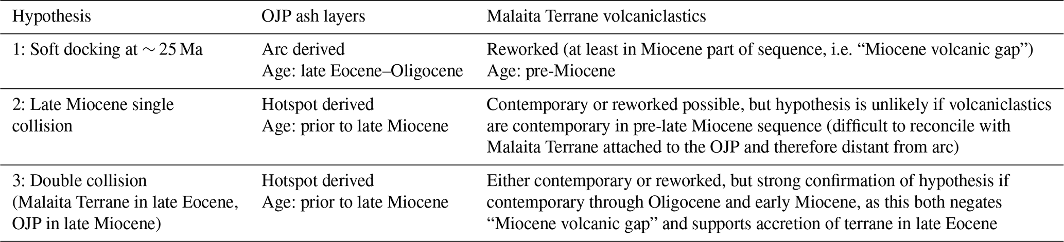
This expedition aims to test three competing hypotheses (Fig. 3).
-
Hypothesis 1 assumes that the collision between the OJP and the Solomon Islands arc was a single tectonic event, which took place at ca. 25 Ma. Although the collision led to an immediate plate kinematic response – halting or reducing Pacific plate subduction – the effect of arc reversal was protracted and only occurred at ca. 10 Ma (Kroenke, 1984; Yan and Kroenke, 1993; Kroenke et al., 2004).
-
Hypothesis 2 assumes that the collision did not occur until the late Miocene, with polarity reversal following soon after (Mann and Taira, 2004). The plate kinematic change at ∼ 25 Ma (Knesel et al., 2008), according to this hypothesis, was unrelated to the OJP–Solomon Islands collision.
-
Hypothesis 3 assumes a prolonged history of diachronous collision, involving at least two phases of contacts between fragments of Ontong Java Nui and the Solomon Islands arc. The first collision involved a smaller fragment of Ontong Java Nui that collided with the Solomon Islands arc during the late Eocene. The second and final phase of collision involved the main OJP and took place during the late Miocene. According to Hypothesis 3, the late Eocene phase of obduction was followed by continued subduction of the Pacific plate, with subduction congestion and polarity reversal occurring only following the late Miocene phase (Musgrave, 2013).
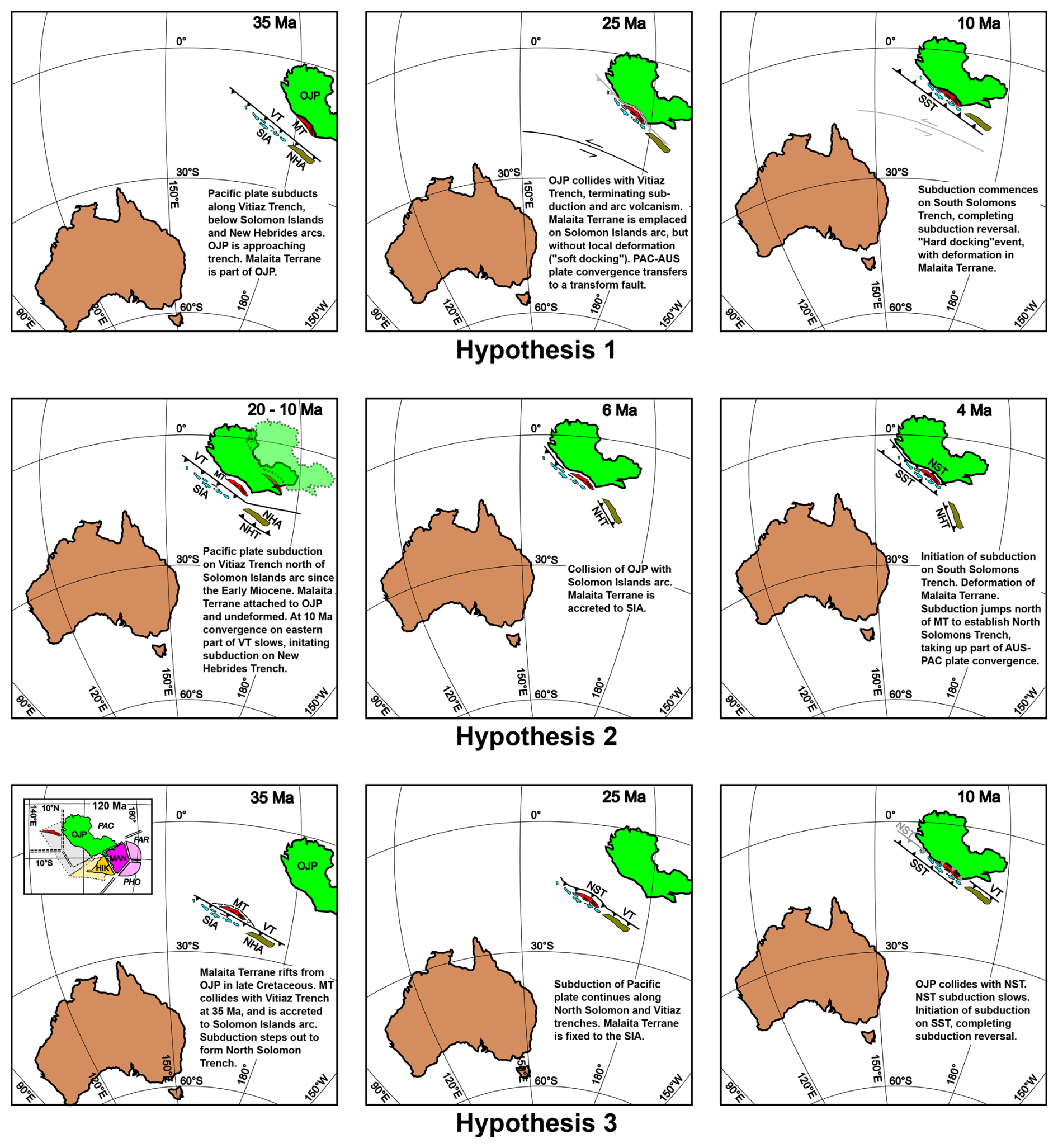
Figure 3The three collision hypotheses (after Kroenke, 1984; Mann and Taira, 2004; and Musgrave, 2013, respectively). Reconstructions of features on Pacific and Australian plates follow the EarthByte Global Rotation Model (Zahirovic et al., 2022). OJP = Ontong Java Plateau, MT = Malaita Terrane, SIA = Solomon Islands arc, NHA = New Hebrides (Vanuatu) arc, VT = Vitiaz Trench, SST = South Solomons Trench, NST = North Solomons Trench, NHT = New Hebrides (Vanuatu) Trench, MAN = Manihiki Plateau, HIK = Hikurangi Plateau, PAC = Pacific plate, FAR = Farallon plate, PHO = Phoenix plate. Inset in Hypothesis 3 shows rifting of Ontong Java Nui at 120 Ma, with lighter colour shades indicating now subducted oceanic plateau elements, following Chandler et al. (2012). Speculative position of Malaita Terrane follows Musgrave (2013). Hypothesis 2 shows positions of OJP and MT at 20 Ma (light fill), and 10 Ma (darker fill), relative to the position of SIA and Australian plate held fixed at 10 Ma.
Central issues to be determined are the timing of the OJP collision(s), and the relative positions of the plateau and the arc prior to collision. This can be achieved by geochemical comparison of volcanic ashes recorded in legacy ODP and DSDP cores on the OJP with an Oligocene–Miocene volcaniclastic sequence from the Solomon Islands arc. The outcome of this research will inform and potentially revise our understanding of the process of arc polarity reversal, oceanic plateau collision, and obduction, and the Miocene palaeogeography of the southwestern Pacific.
2.2.1 Constraints on collision timing
Despite the conceptual significance of the OJP-Solomons collision, the constraints on its timing are limited and inferential. Crucially, most of the record of any Eocene to mid-Miocene back-arc spreading which may have occurred was destroyed by post-reversal subduction along the South Solomons, New Britain, and New Hebrides trenches (Fig. 1). Occurrences of pre-late Miocene back-arc crust are restricted to the South Fiji Basin (Herzer et al., 2011) and the narrow strip of the New Hebrides Basin (Weissel et al., 1977; Seton et al., 2016). The limited constraint provided by these remnants of a far larger back-arc system allows for a variety of allowable reconstructions for the Solomon Islands and New Hebrides arcs in the late Oligocene (Fig. 4), just prior to the timing for the collision implied by most plate reconstruction models (e.g. Yan and Kroenke, 1993; Hall, 2002; Kroenke et al., 2004; Müller at al., 2019). Varying the reconstructed width of the Melanesian back-arcs results in differences in the former position of the Solomon Islands arc and hence of the time of collision between the Solomon Islands arc and the OJP, which has been fixed in the Pacific Plate since the break-up of the larger Ontong Java Nui LIP into the Ontong Java, Manihiki, and Hikurangi plateaus (Taylor, 2006; Chandler et al., 2012).
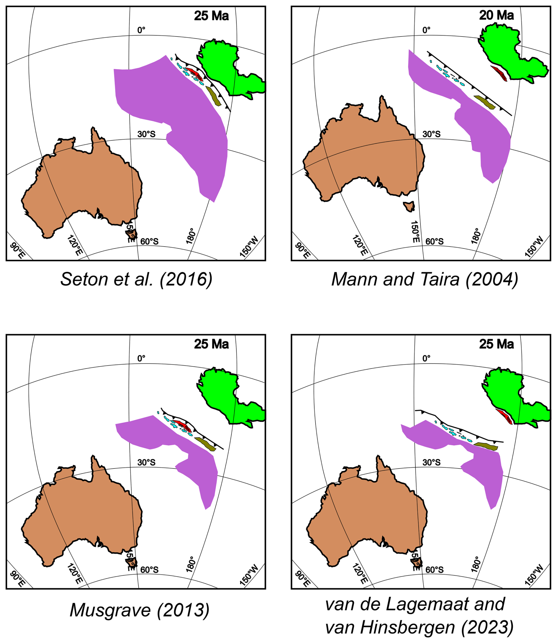
Figure 4Allowable alternative reconstructions for the late Oligocene or early Miocene positions of the tectonic features involved in the OJP – Solomon Islands arc collision. Tectonic elements are coloured as in Fig. 3. Purple areas between the Australian continent and the island arcs represents the extent of Oligocene back-arc basin spreading implicit in each model: most of the extent of these basins has since been subducted along the South Solomons and New Hebrides trenches.
Evidence for the age of the collision has been inferred mostly from on-land geological records. The Malaita Terrane – the northeastern edge of the Solomon Islands comprising Malaita and most of Santa Isabel (Fig. 1) – consists of basaltic rocks, akin to an oceanic plateau, covered by pelagic carbonate sedimentary rocks. The basaltic rocks of the Malaita Terrane are similar to those recovered at ODP Sites 803, 807 (Leg 130), and 1183 and 1185–1187 (Leg 192), both in terms of their crystallisation age (Early Cretaceous) and their geochemical affinity (LIP-type) (Tejada et al., 1996). The Malaita Terrane is therefore considered to be an obducted edge of the OJP (Hughes and Turner, 1977; Coleman and Kroenke, 1981; Kroenke, 1984; Cooper and Taylor, 1985; Tejada et al., 1996, 2002). Cretaceous to middle-Eocene pelagic carbonates lie above the LIP-type basalts on both OJP and the Malaita Terrane. Pre-Pliocene subduction-related volcanism is restricted to the Central Province of the Solomon Islands, including the islands of Guadalcanal and Choiseul, and the southwestern side of Santa Isabel. Arc volcanism was reduced or absent in the Central Province during the early and middle Miocene (Kroenke, 1984).
This apparent time gap in arc volcanism is the basis for the inference that subduction of the Pacific plate ceased at 25–20 Ma due to the collision of the OJP with the Solomon Islands arc (Kroenke et al., 1986; Kroenke, 1989; Yan and Kroenke, 1993; Petterson et al., 1999). Nonetheless, there is no evidence of significant deformation and/or uplift associated with this early Miocene collision. Accordingly, Petterson et al. (1997) introduced the term “soft docking” to describe the process whereby the OJP arrived at the trench, terminating subduction processes, but doing so without triggering deformation at the collisional zone. Considering the role of plate coupling in models of subduction polarity reversal (e.g. Almeida et al., 2022), the geodynamic admissibility of the soft-docking model is questionable. Nevertheless, following the example of the OJP–Solomon Islands collision, the idea that plate tectonics can involve “soft docking/collision” has been widely accepted. Plate tectonic reconstructions incorporating soft-docking events include examples from the Pan-African belt (Triantafyllou et al., 2020), Central Asian Orogenic Belt (Feng et al., 2018; Wang et al., 2024), and Ural Mountains (Matte, 2006).
In the Solomon Islands arc, uplift and deformation occurred during the Pliocene (Resig et al., 1986; Musgrave, 1990; Petterson et al., 1997). It has been suggested that the initial early Miocene “soft docking” was followed by a “hard-docking” event (where plate coupling did result in deformation and uplift) in the Pliocene (Petterson et al., 1999). Initiation of north-eastward dipping subduction on the opposite side of the arc was placed between the soft- and hard-docking events at about 12–6 Ma.
In the regional plate reconstruction model of Hall (2002), the collision of the OJP with the Solomon Islands arc occurred at 18 Ma. After 18 Ma, the plate kinematic model by Hall (2002) assumes a full coupling between the Solomon Islands and the Pacific plate, with Pacific–Australia convergence accommodated at a subduction zone on the southern side of the Solomon Sea at the Trobriand Trough. Initiation of north-dipping subduction of the Solomon Sea on the southern flank of the Solomon Islands arc at 6 Ma halted subduction at the Trobriand Trough but had no significant impact on the motion of the Solomon Islands arc, which continued to be coupled more or less completely to the Pacific Plate. Mann and Taira (2004) rejected the soft-docking model, inferring from seismic reflection profiles and the distribution of earthquake hypocentres that the OJP–Solomons collision, and the subsequent polarity reversal, occurred in the latest Miocene. These authors suggested that the lower 80 % of OJP lithosphere is still subducting along the North Solomons Trench.
2.2.2 Palaeomagnetic record from the Malaita Terrane
Palaeomagnetic studies of the late Eocene to Pliocene sedimentary sequence from the Malaita Terrane (including a late Eocene phase of alkali basalt volcanism on Malaita) yielded palaeomagnetic poles which are distinct at the 95 % confidence level from the apparent polar wander path (APWP) expected for the Pacific plate (Musgrave, 1990) and instead lie close to the Australian APWP (Fig. 5). Plate motion models that invoke early Miocene collision and obduction (e.g. Müller et al., 2019) appear to be incompatible with the palaeomagnetic evidence. An additional pole from the Aptian–Albian mudstones and limestones near the base of the Malaita Terrane sedimentary sequence (Musgrave, 2013) suggests a more complex history, with the terrane having been emplaced much earlier, in the late Eocene, and moving with the Australian plate until completion of the arc polarity reversal in the latest Miocene (see “Hypothesis 3” in Fig. 3).
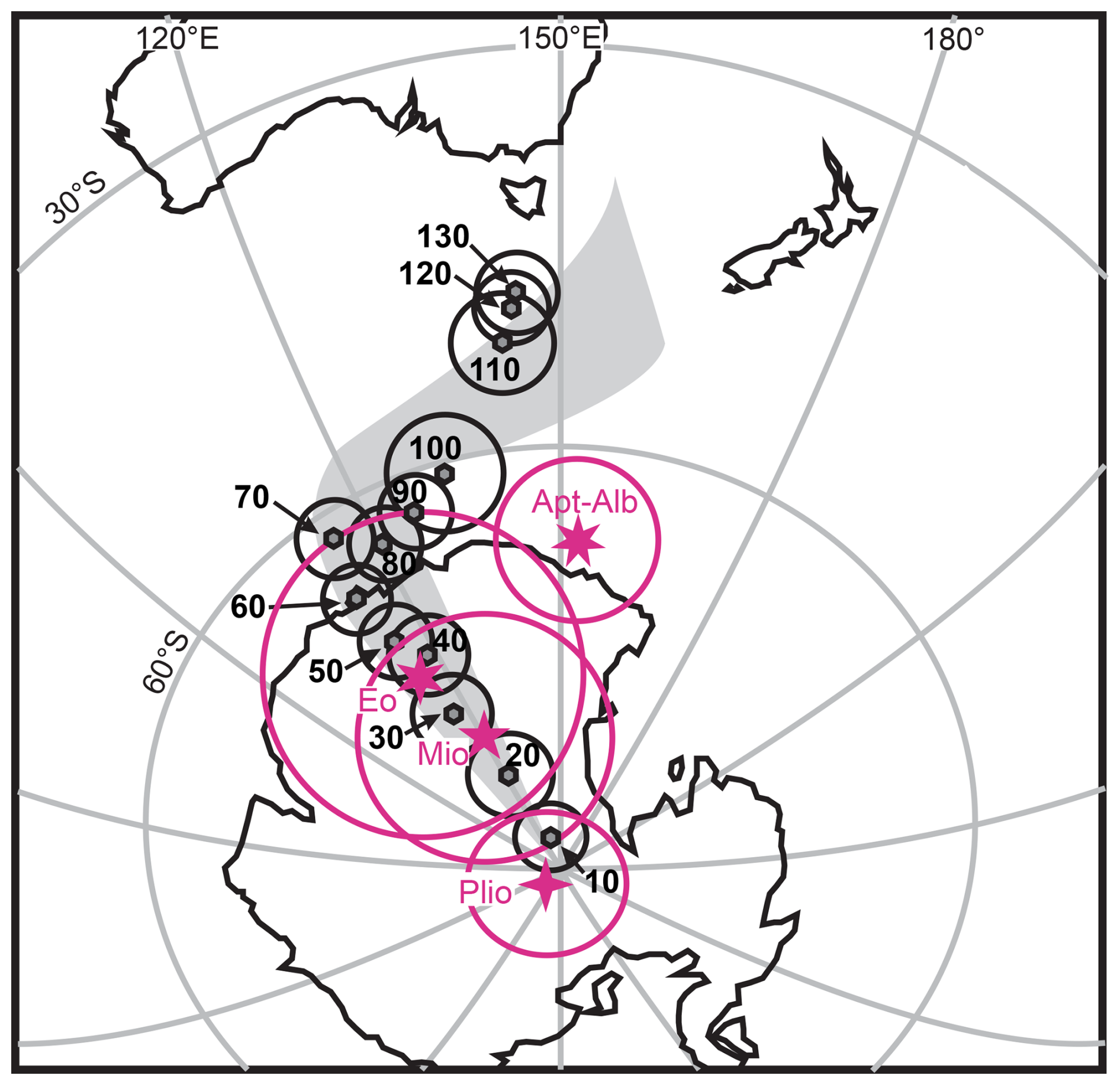
Figure 5Palaeomagnetic poles from the Malaita Terrane (magenta stars, with 95 % confidence circles), compared to the Australian apparent polar wander path (shaded grey trend, and black individual poles). Note the close agreement of the late Eocene (Eo) and Miocene (Mio) Malaita Terrane poles to the Australian path. Simplified from Musgrave (2013).
2.2.3 Comparative stratigraphy of the Malaita Terrane and the OJP
The inconsistencies between the early Miocene plateau-arc collision model and the stratigraphy of the Malaita Terrane appear to go beyond what might be ascribed to soft docking. While the Cretaceous to middle-Eocene basalt and white limestone sequences of both the OJP and the Malaita Terrane are similar, notable differences emerge from the middle Eocene onwards (Fig. 6). Middle-Eocene alkali basalts (Maramasike Volcanic Formation) occur near the top of the white limestones in Malaita; 40Ar-39Ar yielded an age of 44.2 ± 0.2 Ma (Tejada et al., 1996). Similar alkaline rocks are present as intrusive on Santa Isabel (Hawkins and Barron, 1991). Pipe-like intrusions of alnöite in northern Malaita were emplaced at about 34 Ma, after a protracted magmatic evolution spanning 17 Myr (Simonetti and Neal, 2010). Although alkali basalts have also been dredged from the southern margins of the OJP, these are substantially younger, with an eruption age of 20–25 Ma (Hanyu et al., 2017). Conspicuously banded limestones (Maruto Limestone and Haruta Limestone formations) conformably overlie the white limestones and alkali basalts. The bands represent the supply of vitric-crystal-rich muds with a likely arc provenance (Hughes and Turner, 1977; Hawkins and Barron, 1991; Petterson, 2004). Foraminiferal ages from the banded limestones of Malaita span the late Eocene (Priabonian) to late Miocene (Hughes and Turner, 1976; Musgrave, 1990); nannofossils from equivalent rocks on Santa Isabel have yielded ages from early Oligocene to middle Miocene (Hawkins and Barron, 1991). The age of the vitric crystals in the mud bands has not been determined. Thus, the question of whether they represent volcanism contemporary with the deposition of the limestones, or whether they are derived from the known pre-Miocene volcanism in the arc, is unresolved. In Santa Isabel, the Kuakula Sandstone Formation – a facies including volcaniclastic sandstones, tuffs, and conglomerates that include boulders of andesite (Hawkins and Barron, 1991) – is considered to interfinger with the Maruto Limestones.
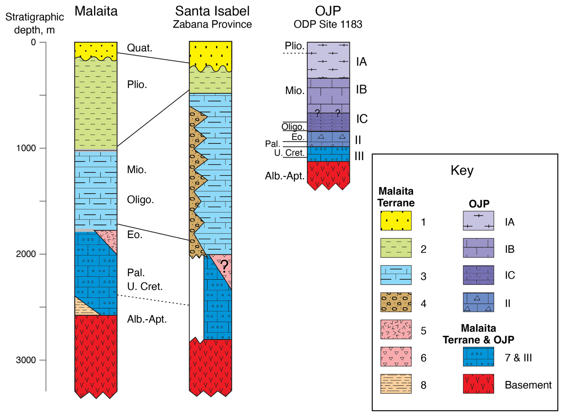
Figure 6Stratigraphy of the Malaita Terrane and OJP. Vertical scale in metres. Key to stratigraphic sequence: 1 = late Pliocene–Holocene limestone, siltstone, and conglomerate; 2 = Suafa Limestone Formation (calcareous siltstones and pelagic limestones, latest Miocene–Pliocene); 3 = Haruta Limestone and Maruto Limestone formations (limestones with terrigenous, partly volcaniclastic turbidite layers, late Eocene–late Miocene); 4 = Kuakula Sandstone Formation (volcaniclastic sandstones and conglomerates, ?late Eocene–Miocene); 5 = Maramasike Volcanic Formation (alkali basalts, middle Eocene); 6 = Ruruma Volcaniclastic Formation (?middle Eocene); 7 = Alite Limestone and Bara Limestone formations (chert-bearing limestones, Albian–middle Eocene); 8 = Kwara'ae Mudstone Formation (siliceous mudstone, Aptian–Albian); IA = foraminifer nannofossil ooze (middle Miocene–Pleistocene); IB = foraminifer nannofossil chalk (earliest Miocene–middle Miocene); IC = nannofossil foraminifer chalk, nannofossil foraminifer limestone, and volcanic ash layers (Oligocene–earliest Miocene); II = limestone with abundant chert (Eocene) or with zeolite layers (Palaeocene); III = limestone. After Musgrave (2013).
To summarise, the Oligocene to Miocene stratigraphy of the Malaita Terrane appears inconsistent with the Malaita Terrane lying distant from the arc and is difficult to reconcile with the hypothesis that the Malaita Terrane was part of the OJP until the presumed early Miocene collision (“Hypothesis 1”). The stratigraphic record from the Malaita Terrane, combined with the palaeomagnetic data, led Musgrave (2013) to conclude that the Malaita Terrane was originally a fragment of Ontong Java Nui. It was rifted from the OJP (in a similar fashion to the Manihiki and Hikurangi plateaus; Taylor, 2006) and collided with the Solomon Islands arc in the late Eocene. The emplacement of the Malaita Terrane did not cause subduction termination and/or reversal, as indicated by the evidence for continued subduction of the Pacific plate along the North Solomon Trench (Mann and Taira, 2004; Taira et al., 2004). It was only when the main body of the OJP collided with the Solomon Islands arc, during the late Miocene, that arc polarity reversal occurred (Musgrave, 2013).
2.2.4 Tectonic significance of ash record from the OJP
The age distribution of ash layers from the OJP holes (Fig. 7) was investigated by Kroenke et al. (1993). The authors recognised a decreased frequency of ashes dated 25–10 Ma, ascribing this observation to the gap in volcanism in the Solomon Islands, which according to Kroenke et al. (1993), was associated with the ending of subduction along the Melanesian Trench. This interpretation is an essential component of the soft-docking model. More abundant ashes in the late Eocene through Oligocene were attributed to Melanesian arc volcanism, with the presence of the ash on the plateau explained by the assumed proximity of the arc and plateau during the period of oblique convergence that preceded collision (Kroenke, 1984). Coring at Site 1183 recovered a similar sequence of Oligocene to earliest Miocene ashes (Shipboard Scientific Party, 2001).
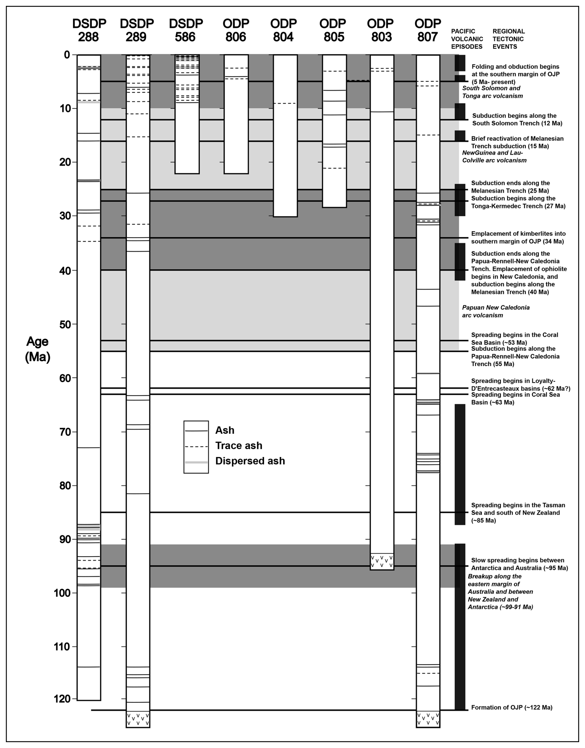
Figure 7Stratigraphic occurrences of ash at drill sites on the OJP (up to Leg 130), shown with periods of arc volcanism, Pacific volcanic episodes, and other regional tectono-volcanic events. Adapted from Kroenke et al. (1993).
Determining the age and geochemical characteristics of the ash layers is the only direct means to provide evidence for the relative positions of the OJP and the Solomon Islands arc for times prior to the late Miocene (palaeomagnetism would have that potential, but the palaeomagnetic record from the OJP is poor; Musgrave et al., 1993). Despite the significance of the tectonic interpretation of the ash record, there has been no reported petrological, geochemical, or isotopic test of the implicit assumption that the ashes are derived from a volcanic arc source, and from the Solomon Islands (or other parts of the Melanesian arc) in particular. This is despite the presence of alternative potential volcanic sources in the western Pacific, notably the Samoan and other hotspot chains (Jackson et al., 2024). This knowledge gap will be addressed by this expedition.
2.3 Palaeoclimate study: provenance and deposition of dust and dispersed volcanic ash in the western equatorial Pacific during the Eocene to Miocene
In addition to ash layers, volcanic ash can be deposited as dispersed ash mixed in the bulk sediment. Dispersed ash is the result of bioturbation of pre-existing discrete ash layers or the result of the settling of airborne or subaqueous ash – perhaps from a small or distal, continuous, or non-continuous eruption – that is slow enough not to form a discrete layer (e.g. Scudder et al., 2016). Alterations to the dispersed volcanic ash can make it petrographically indistinguishable from the dust, but there are geochemical and statistical techniques that can identify the original provenance. Expedition 504S will unravel the complex mixture of multiple dust and ash sources to reconstruct the history of volcanic activity, aridity, and wind direction and intensity on the OJP.
Positioned near the Equator and accumulating sediments throughout most of the Cenozoic, the OJP is a unique location to simultaneously reconstruct the history of multiple aeolian processes. The OJP lies within the southern fringe of where Asian dust reaches in the modern day, the northern edge of where Australian dust is blown, and may also receive aeolian material from the Americas blown across the Pacific by the easterlies (Fig. 8; Mahowald et al., 2005; Albani et al., 2015; Kok et al., 2021). Mixed with the dust derived from continental crust is volcanic ash from multiple nearby sources since at least the Eocene (Krissek and Janecek, 1993). Which dust source is dominant at any given time may depend on the strength of the global monsoon system and the location of the ITCZ. For most of its Neogene history, the OJP has been located close to the Equator, making it highly sensitive to changes in these global aeolian processes.
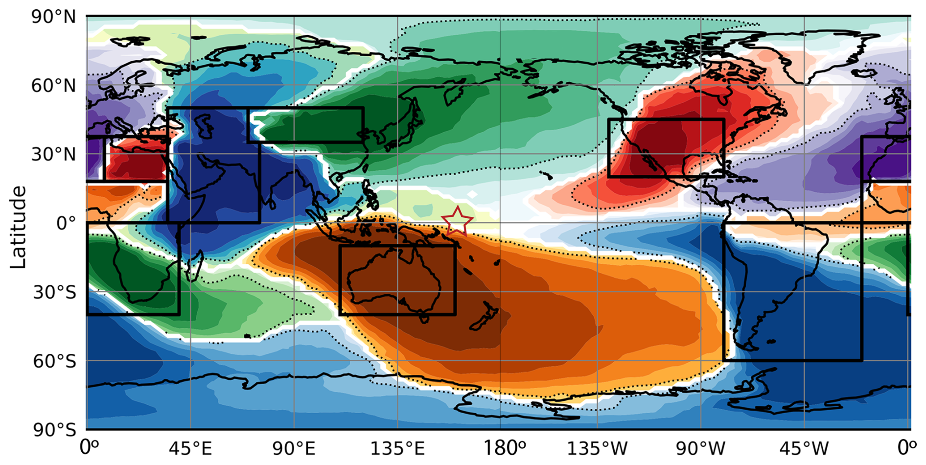
Figure 8Percentage of dust deposition supplied by the dominant source region across the globe. Colours represent different dominant source regions, with shading decreasing in 10 % increments (50 % is the dotted black contour). Black boxes denote the nine major source regions of dust. White shading denotes areas where two or more dust source regions contribute similarly to the deposition flux. The red star indicates the location of the OJP. Note: wind-blown or submarine volcanic ash are not considered in this map but are also sources of aluminosilicates to the OJP. Figure modified from Kok et al. (2021), used under CC BY 4.0 (https://creativecommons.org/licenses/by/4.0/, last access: 17 April 2026).
Previous work on the OJP carbonate sequence established the presence of mineral assemblages interpreted as dust and aerosols derived from Asia since the Oligocene (their oldest samples), with the greatest relative importance in the middle Miocene and the Pliocene through Quaternary (Krissek and Janecek, 1993). Plagioclase supply to the OJP during the Oligocene to early Miocene came from a different source. Although the possibility that the plagioclase was supplied from the Americas by easterlies was explored (Schoonmaker et al., 1985), Krissek and Janecek (1993) preferred an interpretation that considered a local source derived from the (presumed nearby) Melanesian arc. Kroenke et al. (1993) made a similar interpretation regarding the source of the ash layers. A decrease in the proportion of plagioclase-rich dust in the early Miocene was taken to reflect the cessation of volcanism in the Melanesian arc due to the OJP collision. However, the data available at the time were insufficient to distinguish between an American or local volcanic source, and their preference for a Melanesian arc source depended on this perceived temporal association. Expedition 504S aims to determine the compositional record and isotopic ages for both the OJP ashes and, separately, the volcaniclastic record from the Malaita Terrane would provide the missing basis on which to distinguish the likely relative contributions of the dust sources and local volcanic sources.
There have been substantial changes in the strength of the East Asian Monsoon since the Eocene (e.g. An, 2000; Shen et al., 2017; Anderson et al., 2019). Expedition 504S will test the hypothesis that dust from Asia increased with the intensification of the East Asian Monsoon, delivering more dust to the western equatorial Pacific. Intriguingly, the early Miocene to late Miocene interval – over which both the plagioclase dust component from Krissek and Janecek (1993), and the frequency of ash layers decrease – corresponds to the interval of maximum strength of the East Asian Monsoon (Clift et al., 2014). The position and migration of the ITCZ also likely plays a role in the provenance of dust deposited on the OJP. Data obtained from Expedition 504S will allow us to determine the source of the dust component over this time. Expedition 504S will use geochemical, mineralogical, and other tools that can differentiate dust from the various continents possibly contributing dust to the OJP. Expedition 504S will also extend the aeolian dust records from OJP back into the earlier Paleogene and Late Cretaceous.
Distinguishing the volcanic ash and different sources of dust will allow us to examine the relative importance of various aeolian sources. Investigating the covariance of the dust and volcanic ash sources will allow us to reconstruct past wind directions, as being separate from aridity or volcanic activity (e.g. Dunlea et al., 2015). Differentiating dust and volcanic ash will also help to define the extent of volcanic ash deposition in the ocean, determine the primary sources of micronutrients to the ocean over time (e.g. Zhang et al., 2024), and characterise the geochemistry of marine sediment that will eventually be subducted and become part of the subduction zone factory (e.g. Plank and Langmuir, 1998). Additionally, quantifying the dispersed ash component will inform which type of volcanic ash is being deposited between the volcanic ash layers, thereby supporting the other goals of this proposal.
Expedition 504S will combine the application of analytical techniques beyond what has already been performed on cores from Leg 130, including quantitative element concentrations of samples (high-resolution XRF scanning, ICPES, (LA-)ICPMS), isotopic composition, and chronological tools with the geochemical and age analysis of the larger ash fractions preserved as ash layers. It will also assess changes in dust and ash sources over time, and assess the competing contributions of aridity, changing volcanic activity and proximity to source, changes in tectonic and climatic setting of the sites, and variations in wind strength and direction.
Our scientific objectives are twofold: tectonic and palaeoclimatological.
3.1 Tectonic objectives
Our principal tectonic objective is to test the legitimacy of the soft-docking model for the collision of the OJP and Solomon Islands arc, and weigh the soft-docking model against two competing hypotheses: the single late Miocene collision of Mann and Taira (2004), and the repeated collision model of Musgrave (2013). The broader objective is to investigate the mechanism of subduction reversal in the prototypical example of this form of subduction initiation, a key aspect of Strategic Objective 2 (the Oceanic Life Cycle of Tectonic Plates) of the 2050 Science Framework.
The three competing hypotheses for the collision have corollaries in the mechanism of plateau subduction: the soft-docking model (Hypothesis 1) suggests that collision with the buoyant plateau caused a rapid halt to subduction with limited local tectonic effects; the late Miocene to Pliocene collision model (Hypothesis 2) infers continued subduction of the lower 80 % of the plateau lithosphere after collision, accretion of the Malaita Terrane, and initiation of subduction reversal. The repeated collision model (Hypothesis 3) requires an initial collision in the late Eocene of a comparatively small fragment of the larger Ontong Java Nui plateau, in which subduction continued and the plateau fragment was entirely consumed other than accretion of the Malaita Terrane, with subduction reversal not occurring until the larger OJP collided in the late Miocene. Which of these three contrasting styles of plateau collision and subduction reversal proves to be correct will provide important constraints on subduction zone behaviour, and the obduction and accretion of LIP crust – other prime concerns of Strategic Objective 2.
An additional objective relates to the relationship of the alkaline volcanic sequence of the Malaita Terrane, the OJP, and the Samoan hotspot. If the OJP ashes prove to have a Samoan hotspot origin, this may help to fill a gap in the Samoan hotspot record (Jackson et al., 2024) and contribute to our understanding of this hotspot volcanism system, another focus of Strategic Objective 2. The relative positions of the OJP, the Malaita Terrane, and the Samoan and other hotspots at the time of emplacement of the late Eocene Malaita alkaline volcanics differ in the three collision models: if the double collision model is correct, the alkaline volcanics would have had a similar outer-trench swell setting at the time of their eruption to that of the early Miocene seamounts on the southern flank of the OJP (Hanyu et al., 2017). Given this common setting, both the early Miocene OJP seamounts and the late Eocene alkali volcanics may represent petit-spot volcanism (Hirano, 2011), also addressed in Strategic Objective 2.
3.2 Palaeoclimate objective
The principal palaeoclimate objective of Expedition 504S is to unravel the sources of dust and volcanic ash to the OJP and reconstruct the history of deposition of dust and volcanic ash in this part of the western equatorial Pacific over key periods in the Cenozoic. Specifically, Expedition 504S will test the hypothesis that the intensification of the East Asian Monsoon increased dust delivered to the western equatorial Pacific. Wind-blown dust and volcanic ash are a key part of Earth's Climate System (Strategic Objective 3) and Tipping Points in Earth's History (Strategic Objective 5). Unlike previous studies of OJP aeolian materials, the integration of geochemical evidence for the source of the layered ash, with its implications for the direction and distance of the source from the deposition site, will allow direct inferences of the strength and direction of winds before and during the onset of the East Asian Monsoon, a component of Earth's monsoon systems which are a specific focus of Strategic Objective 3.
4.1 Targeted legacy resources
The tectonic component of Expedition 504S will analyse volcanic ash layers previously identified in the DSDP and ODP sites on Ontong Java Plateau (Table 1). Samples of 10 cm3 volume will be taken from the working-half of cores.
Table 1Ontong Java Plateau sites with identified Eocene to Miocene ash layers.
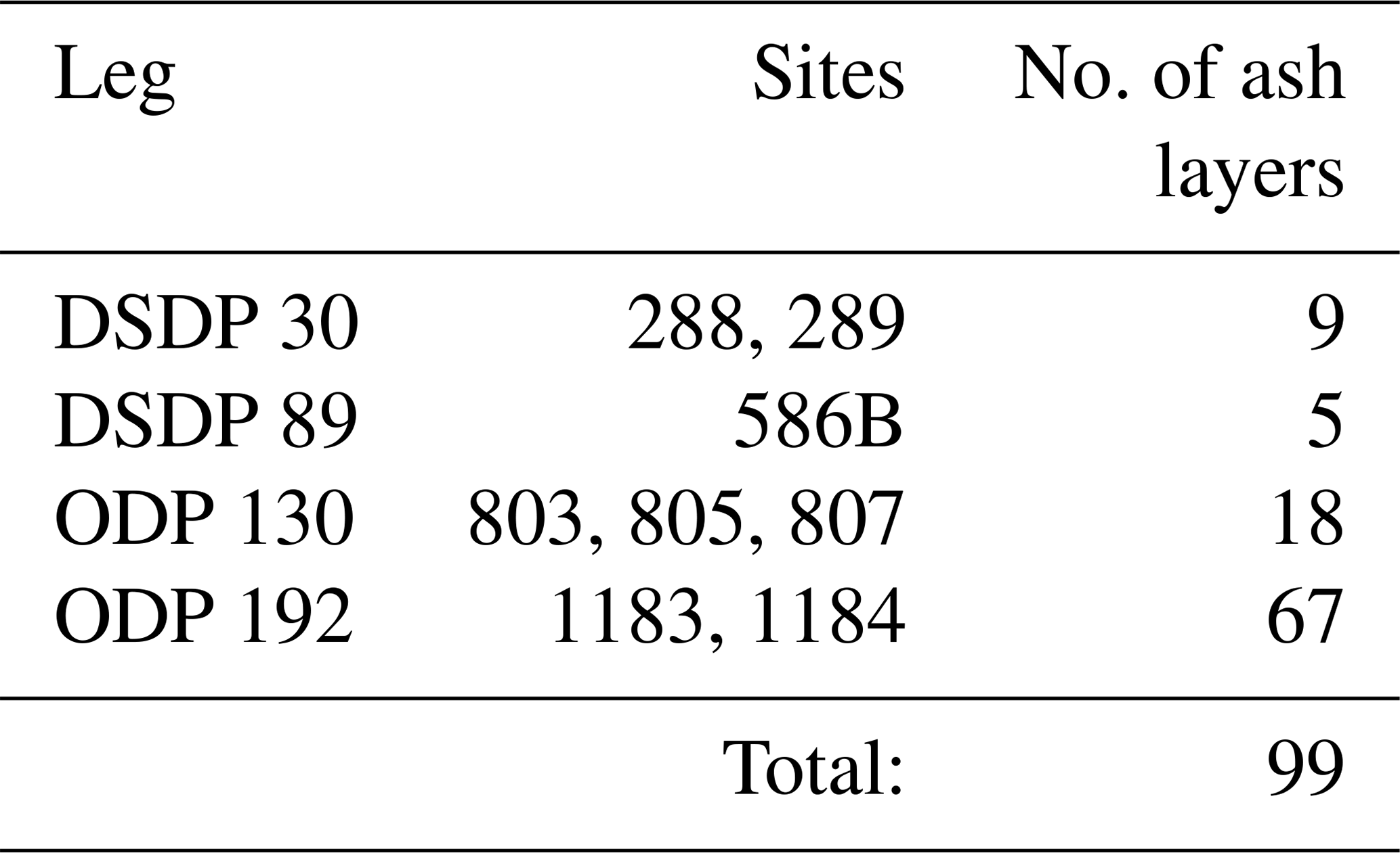
All cores are held at the Gulf Coast Repository (GCR) in College Station, Texas. A proof-of-concept preliminary study of 10 trial samples from Legs 130 and 192 indicated that 10 cm3 samples contained substantial proportions of ash (with further material remaining unsampled in the working-half cores) and confirmed the excellent preservation of both the cores, all of which showed no signs of significant disturbance, excess sampling, or the development of mould.
The palaeoclimate component will involve 20 cm3 samples of carbonate oozes, chalks and limestones at a sampling rate of at least one sample per core from the Pleistocene to Eocene sequence cored on ODP Legs 130 and 192. Additional samples in individual cores, and sampling of cores older than the Eocene, will be considered, based on sampling requests from the Science Team and subject to curatorial approval.
The expedition will also conduct non-destructive analysis of the archive half-core sections corresponding to the working-half sections sampled for both the tectonic and palaeoclimate studies, using the facilities of the GCR. Sample selection may be adjusted depending on the results of X-ray fluorescence (XRF) scanning and other non-destructive measurements of the cores.
4.2 Sampling and data-sharing strategy
Applicants for the Expedition 504S Science Team should refer to the Sample, Data, and Obligations Policy (https://iodp3.org/documents/sample-data-obligations-policy/, last access: 17 April 2026). This document outlines the policy for distributing scientific ocean drilling samples and data to research scientists, curators, and educators. The document also defines the obligations that recipients of samples and data incur. The SPARC co-chief scientists, in discussion with the curators of the core repositories, will work with the entire SPARC Expedition Science Team to develop a formal implementation plan once the team is assembled following the open call for participation. The implementation plan will include the following:
-
Detailed plans for collaboration between SPARC Expedition Science Team members, how this will be facilitated and managed to promote focused research and progress (e.g. plans for in-person sampling at the core repositories, frequency of dedicated virtual and in-person meetings of the Science Team), and how results will be disseminated,
-
Outline discussions held with the curators of the core repositories regarding the availability of core materials, and plans for accessing and using repository facilities,
-
Plans for obtaining additional funding to complete the research, if this cannot be achieved using the EUR 300 000 SPARC award,
-
A Gantt chart showing the timelines for the research, key milestones, and deliverables.
Every member of the SPARC Expedition Science Team will be obligated to carry out scientific research for the expedition and publish the results, by contributing to the production of the SPARC Expedition Summary and Results in the Proceedings of the International Ocean Drilling Programme and by publishing in other scientific journals. All SPARC Expedition Science Team members are required to submit their own detailed research plans and associated sample/data requests via the Sample, Data, and Research Request Manager (SDRM) system (https://web.iodp.tamu.edu/SDRM/#/, last access: 17 April 2026) in order to receive samples to work on. However, sample requests must be provided to the SPARC Expedition co-chief scientists prior to submission to allow them to coordinate sampling efforts, avoid duplications, and resolve sampling conflicts between Science Team members. However, subsequent sharing of allocated samples between Expedition 504S Science Team members to facilitate integrated analyses will be encouraged.
Core research activities of the Expedition 504S Science Team will comprise geochemical analysis of sampled ashes, cryptotephras, the carbonate sequence, physical properties studies of spectral colour and magnetic susceptibility, grain-size analysis, XRF core scanning, and palaeogeographic reconstruction. We strongly encourage applicants to suggest other areas of research and alternative methodologies, where they believe these will support and strengthen the tectonic and palaeoclimate aims.
In order to make most efficient use of both funding and laboratory space at the GCR, a subset of the Science Team will participate in the repository phase and conduct core description, sample acquisition, and physical properties and XRF analysis. This subgroup will take measurements on the two core-scanning XRFs available at the GCR at a 10 cm spacing, using 10 and 30 kV sources. At the end of the repository phase, any remaining XRF scanning will be completed by the GCR staff. The description, physical properties, and sampling teams will also work within this shift framework. We envisage the total size of the subset of the Science Team working at the GCR to be 18, broken into two shifts of nine persons, each comprising a co-chief, two ash describers, two carbonate describers, a physical properties specialist, an XRF specialist, and two samplers, with some rotation of roles to maximise efficiency. Training of the Science Team members will comprise two additional days prior to commencement of sampling. The rest of the Expedition 504S Science Team will be kept abreast of, and be able to help direct, the activities of the sampling team through a daily Zoom briefing, to be held at a time best suited to the shifts of the Science Team members present in the GCR and the time-zone distribution of the rest of the Science Team.
We expect there to be a range of analytical techniques applied to the ash samples, with different Science Team members wanting to focus on particular mineral phases (glass, zircons, apatite, or other phenocrysts) or on bulk chemistry. To ensure that all team members have access to the full range of materials, samples will go through an initial stage of description, petrography, grain-size analysis, and X-ray diffraction (XRD), followed by glass shard picking and mineral separation, before aliquots of the sample extracts are distributed to the corresponding team members. Selection of the laboratory responsible for this initial processing step will be determined after the Science Team is announced and following discussions between team members and the co-chiefs. A similar strategy will be followed for the major and trace element analysis of the cryptotephra and carbonate samples, with a selected laboratory tasked with the initial steps of grain-size analysis, XRD, and separation of terrigenous and volcanogenic materials, prior to distribution of aliquots to requesting Science Team members.
Complementing the sampling and analysis of ashes from archived cores hosted at the GCR, a second, field-based team, operating parallel to, but outside of, the SPARC Expedition framework, will collect samples of the volcaniclastic-bearing layers and enclosing carbonates from the islands of Malaita and Santa Isabel in the Solomon Islands. This work will be conducted in collaboration with the Solomon Islands Geological Survey Division (SIGS). A staff geologist from SIGS will take part in the field sampling, and if approved, will also join the group at the GCR as part of the SPARC “Widening Participation” initiative. The field-based programme will operate outside the SPARC funding, staffing, and mechanisms but will be under the direction of members of the proponent team for Expedition 504S, and we will require members to follow equivalent conditions on publication and authorship, including embargoes and a requirement to contribute to a summary paper, to be jointly authored with the Expedition 504S Science Team and published in the Proceedings of the International Ocean Drilling Programme. We strongly encourage applicants to Expedition 504S to consider parallel involvement in the field-based sampling and analytical team.
We aim to build a cohesive and unified Science Team, with a strong spirit of camaraderie supporting complementary and synergistic science. To support this aim, we will establish a programme of frequent and regular online team meetings, beginning with an extended briefing session immediately after the announcement of the Science Team. Following the sampling session at GCR, with its daily team meetings, we will continue with monthly meetings of informal “Tectonic” and “Palaeoclimate” groups (with members of both groups encouraged to contribute when appropriate to the other group), and 3-monthly meetings of the entire Science Team, where we will also invite participation of members of the field-based study team. The co-chief scientists will also propose sessions at the European Geoscience Union General Assembly and other conferences best suited to the geographic distribution of Science Team members, and encourage Science Team members to participate, as an opportunity to both disseminate results and build connection in the team. A final “wrap-up” meeting will coordinate the contributions to the Proceedings volume. Finally, we hope to achieve some of the “feel” of a traditional sea-based drilling expedition by producing a regular newsletter, hosting an expedition website, and running a T-shirt design competition in the Science Team, with all participants to have the design printed on a shirt they supply.
4.3 Analytical techniques and methodologies
Studying the geochemical provenance, and age of the OJP ash layers and dispersed ash will address both aspects of the SPARC project. The tectonic study will use new data from the ash layers to conduct a comparative analysis of the age and provenance of the volcaniclastic units in the Malaita Terrane. Thus, we will be able to assess the inferences that can be drawn from the OJP ash record for the likelihood of each of the three competing hypotheses for OJP collision and subduction reversal. The palaeoclimate study will use the results of the ash-layer analysis to elucidate the likely source of dispersed ashes through the OJP carbonate sequence. The new information will be compared with non-volcanic dust sources, thus allowing us to derive inferences for the evolution of aeolian sediment supply to the western equatorial Pacific during the Cenozoic, including the influence of an evolving East Asian Monsoon.
4.3.1 Tectonic study
To differentiate between the three hypotheses, the following two questions will be addressed:
- 1.
Are the pre-late Miocene ashes on the OJP (dominantly) arc volcanic or hotspot sourced?
- 2.
Are the volcanically derived materials in the Eocene to late Miocene sequence on the Malaita Terrane contemporary with the enclosing carbonates (which have been dated by biostratigraphy) or are they reworked from earlier pre-Miocene arc volcanism?
The link between the three hypotheses and the answers to the above questions is outlined in Table 2.
The question of whether the OJP ash layers represent hotspot intraplate volcanism or island arc calc-alkaline volcanism could be resolved by geochemical analysis of the ash matrix, allowing for the consequences of devitrification, alteration, and dilution by carbonate introduced by bioturbation. Even in the worst case, where we are unable to successfully separate and analyse glasses, zircon, apatite, or other phenocrysts, this should provide a first-order answer to our most fundamental tectonic question: did the ashes arise from a volcanic arc or not?
A complete characterisation of the source type, and comparison with established isotopic signatures of pre-Miocene volcanics from the Solomon Islands (Tapster et al., 2014) and with Samoan and other western Pacific hotspot basalts (Jackson et al., 2024), will involve separation and analysis of glass (if preserved), zircons (more likely to be present in arc-derived ash), and other phenocrysts. The Expedition 504S proponents have workshopped a proposed methodology, outlined below: we envisage that this will be modified and enhanced following initial discussions with the Science Team after its selection.
Ash samples will undergo an exhaustive analytical routine, comprising sample description and grain-size analysis, optical petrography, and XRD, followed by preparation for microanalysis by the picking of glass shards and mineral separation for zircon, apatite, and other phenocrysts. For some cemented ashes, we will use high-voltage pulsed power discharges, which allows a more efficient fragmentation of rock samples to monomineralic grains. To determine geochemical affinities (e.g. arc related vs hotspot related), we suggest the use of electron probe microanalysis (EPMA) for mineral analysis and a laser ablation mass spectrometer (LA-ICPMS) for minerals, glass, and matrix analyses. These analyses will produce major and trace element geochemistry of glass and phenocrysts, as well as microcrystalline matrix and zircon/apatite trace element data. We also suggest the use of LA-ICPMS to determine isotopic ratio measurements on representative samples to further fingerprint volcanic sources, and to allow U-Pb dating of zircon and apatite grains.
An implicit assumption of the OJP ash-layer analysis is that the volcanic sources are in a direction and distance that is consistent with wind transport. This will be addressed in conjunction with the palaeoclimate study, by an assessment of the volume and grain-size distribution (especially at the coarse end) of the ash layers. Grain size and ash volume will be determined by a combination of detailed visual description of the corresponding archive sections, smear slide analysis (supplementing the limited, and frequently absent, shipboard smear slide description), grain-size analysis, and the continuous XRF scan.
Paralleling the sampling and analysis of ashes from archived cores hosted at the GCR, a second, field-based team will collect samples of the volcaniclastic-bearing layers and enclosing carbonates from the islands of Malaita and Santa Isabel in the Solomon Islands. This work will be conducted in collaboration with the Solomon Islands Geological Survey (SIGS). A staff geologist from the SIGS will take part in the field sampling, and if approved, will also join the Science Team members at the GCR as part of the SPARC “Widening Participation” initiative. Although outside the direct scope of Expedition 504S, the work of the field-based team will be closely integrated with the tectonic study.
Field sampling in the Malaita Terrane will involve the collection of hand samples of the Haruta Limestone, Maruto Limestone, and Kuakula Sandstone formations. The age of the enclosing carbonate rocks will be determined from foraminifer and nannofossil biostratigraphy, which has previously been shown to yield well-defined results in these rocks (Musgrave, 1986, 1990). Volcaniclastic material will be processed by the same procedures used for the OJP ashes.
4.3.2 Palaeoclimate study
The palaeoclimate study will exploit the information regarding the volcanic source and timing of visible ash layers to indicate the supply of the ash component to the aeolian dust supply. The inferences drawn from the tectonic study regarding volcanic activity in the region and the changing spatial relationship between the Melanesian volcanic arc system and the OJP over the Cenozoic will place constraints on the wind direction responsible for ash supply to the OJP, potentially including over the Miocene strengthening of the East Asian Monsoon. Studies of dispersed ash will elucidate the evolution of the relative contributions of volcanic ash and dust sources from Asia, Australia, and the Americas. Overall, we intend to characterise downhole changes in provenance with a combination of semi-quantitative, non-destructive core measurements (MSL, scanning XRF) and more quantitative analyses of discrete samples (XRD, ICP-ES/ICP-MS). Synthesis of the various measurements and multivariate statistics will help to unravel the different sources of dust and dispersed volcanic ash at each site.
Dispersed ash and dust in sections of archive-half cores corresponding to discrete samples will be monitored using the array of analytical sensors available in the GCR. We will use the Section Half Multisensor Logger to measure point magnetic susceptibility (MS) and colour reflectance: both of these represent substantial improvements in data quality and reproducibility over the subjective colour descriptions and loop-coil MS measurements that were available at the time of the previous DSDP and ODP expeditions. MS can be expected to increase in the presence of volcanic ash. Colour reflectance measurements may be able to recognise colour bands representing cryptotephras, as described by Lind et al. (1993), even if these have been degraded by storage. Digital images of archive-half sections taken with the Section Half Imaging Logger will give much better resolution of fine cryptotephra layers than the conventional film photography provided in DSDP and ODP expeditions. We will take advantage of the XRF core scanner to provide semi-quantitative chemical analysis of the dispersed ash and dust component. We will take measurements at a 10 cm spacing, using 10 and 30 kV sources.
As for the tectonic study, the proponents workshopped a preliminary approach to the analysis of discrete samples, as described below: we expect this to be modified and enhanced through discussions with the Scientific Team, and we encourage Science Team members to propose alternate strategies or methodologies.
For mineralogical analysis, discrete core samples taken from the working half will be analysed by smear slide and grain mount/thin section microscopy. Terrigenous and volcanogenic materials will be isolated from the carbonate matrix by a series of buffered chemical extractions (Rea and Janecek, 1981). Extracts will be weighed and grain size determined with a laser particle-size analyser. The mineralogy of the extracts will be determined by X-ray diffractometry (XRD).
For quantitative element concentrations, discrete samples of bulk sediment will be taken regularly throughout the core, and above and below ash layers. Ideally, the sample selection would be guided by the results of the continuous measurements (MSL and scanning XRF) to target sampling near local minimums, local maximums, and significant transitions. Samples will be freeze dried and powdered in agate mortar and pestle. For quantitative major element concentrations, samples will be digested with a flux fusion technique (Murray et al., 2000) and analysed on an inductively coupled plasma emission spectrometry (ICP-ES). For trace and rare earth element concentrations, samples will be dissolved in a heated acid cocktail (HNO3, HCl, HF, H2O2) and analysed on an inductively coupled plasma mass spectrometer (ICP-MS; e.g. Dunlea et al., 2015).
The quantitative ICP-ES and ICP-MS concentrations will be used to calibrate the scanning XRF results (Dunlea et al., 2020). Additionally, the ICP data will be interpreted with multivariate statistics.
Principal component analysis using Python scripts will be applied to the results from XRD. The outcome should be able to identify mineral assemblages that are behaving similarly throughout the XRD dataset, suggesting a common source.
For the ICP element concentrations, we will use a series of discriminatory techniques to determine the provenance of dust and volcanic ash in the discrete samples. To begin characterising the element correlations and relationships, we will compare coefficients of determination R2, x vs y plots, and ternary diagrams of various combinations of element concentrations (e.g. Dunlea et al., 2015; Scudder et al., 2016). Downhole profiles of element concentrations and ratios (ICP and calibrated scanning XRF) will depict downcore changes in composition. We will apply Q-mode factor analysis to identify covariance of multiple elements amongst samples. We expect that the resulting factors will suggest multiple compositionally-unique dust and volcanic ash sources. We will follow up by constructing a constrained least squares multiple linear regressions (CLS) model to determine the mass fraction of each aluminosilicate source in each sample. The discrete ash-layer composition analysed in other parts of this proposal will be considered as end members for the CLS model. Ideally, we convert the modelled mass fractions into mass accumulation rates with an age model. These end results will assess how the various sources and fluxes of dust and volcanic ash change over time.
4.3.3 Synthesis
We will combine the results of the tectonic and palaeoclimate studies to create a palaeogeographic reconstruction of the relative positions of the Solomon Islands arc, Malaita Terrane, and the Ontong Java Plateau, from the Eocene to the present. We will present the reconstruction in the form of a set of GPlates rotation and feature files, and as maps at 10 Ma intervals. Each map will include a graphic of the proportions of volcanic ash, and dust from each of the source regions, at each scientific drilling site on the OJP at the corresponding time.
4.3.4 Risk mitigation
Proponents of the proposal leading to Expedition 504S identified a series of risks to the analytical plan and have taken steps to mitigate these. Given the age of the cores, many of which were drilled in 1990 or earlier, we were concerned by the risk of poor preservation and previous oversampling. We also had concerns whether the ash samples would yield pickable glass shards and/or phenocrysts, particularly zircon, which is likely to be rare or absent if the ashes were sourced from intraplate volcanoes rather than arc volcanism. As a proof-of-concept for the sampling, Co-Chief Scientist Robert Musgrave requested five initial samples of ashes, and photographs of 10 intervals of core containing ash to indicate the core condition and extent of sampling. Musgrave also visited the GCR in December 2024, personally selecting a further five trial samples from Legs 130 and 192, and inspecting the corresponding core intervals. The trial sampling was successful, providing 10 cm3 samples containing substantial proportions of ash (with further material remaining unsampled in the working-half cores), and confirming the excellent preservation of both the cores, all of which showed no signs of significant disturbance, excessive prior sampling, or the development of mould. Preliminary analysis of these samples is currently underway. Initial indications are that at least some ash samples will yield phenocrysts. Even in the worst case, when no usable phenocrysts or glasses can be isolated from the ash, the most basic tectonic question – are the OJP ashes derived from a volcanic arc or from intraplate volcanism? – should be decidable on the basis of bulk ash geochemistry and mineralogy determined from XRF and XRD analysis.
A parallel proof-of-concept analysis of the field-based study is also underway, with proponents Robert Musgrave and Gideon Rosenbaum having visited Honiara in February 2025, where they obtained a set of volcaniclastic-bearing samples courtesy of the SIGS. Preliminary observations have identified abundant sand-sized clasts in samples which show little weathering.
As with any research programme, there is a potential need for additional funding to fully secure research objectives. Members of the proponent team have already obtained additional supportive funding from the ANZIC Continent and Ocean Research and Education (CORE) funding scheme, amounting to AUD 20 000. Further funds to support the field-based study and its comparison with results from the core-based ash analysis will be sought from the Australian Research Council. We encourage Science Team applicants to consider other opportunities, in the form of grant funding or in-kind contribution, to support their proposals.
No data sets were used in this article.
RM conceived the original rationale behind this SPARC Expedition, developed and wrote the detailed tectonic research programme, and suggested a potential accompanying role for a palaeoclimate study. AD amplified the scope, and constructed the dispersed ash and palaeoclimate aspects. RM and AD jointly contributed to the final preparation of this prospectus.
The contact author has declared that neither of the authors has any competing interests.
Publisher's note: Copernicus Publications remains neutral with regard to jurisdictional claims made in the text, published maps, institutional affiliations, or any other geographical representation in this paper. The authors bear the ultimate responsibility for providing appropriate place names. Views expressed in the text are those of the authors and do not necessarily reflect the views of the publisher.
This expedition will use legacy samples and data provided by the Deep Sea Drilling Project and Ocean Drilling Program.
Robert Musgrave and Ann Dunlea wish to acknowledge the contributions of the other members of the proponent team, Gideon Rosenbaum, Christoph Beier, and Hironao Matsumoto: we owe particular thanks to Gideon, who was the force behind driving the tectonic question regarding the soft-docking model from tentative beginnings to a mature SPARC proposal. We also wish to thank the team behind an earlier IODP LEAP proposal that served as the nucleus for our SPARC proposal, which included additional members Carlos Maelaua, Daniel Pastor-Galán, Michael Petterson, Jonathan Pownall, Takashi Sano, Simon Tapster, and Maria Tejada. Clinton Roga, director of the Geological Survey Division of the Ministry of Mines, Energy and Rural Electrification, Solomon Islands, lent us every assistance in developing the field-based component of the research programme, and we sincerely thank him and his team. Candice Cartier of the University of Queensland generated plate reconstructions in GPlates that formed the basis of Figs. 3 and 4. We also wish to acknowledge constructive reviews from Ann Briais and an anonymous referee.
This paper was edited by Steffen Kutterolf and reviewed by two anonymous referees.
Albani, S., Mahowald, N. M., Winckler, G., Anderson, R. F., Bradtmiller, L. I., Delmonte, B., François, R., Goman, M., Heavens, N. G., Hesse, P. P., Hovan, S. A., Kang, S. G., Kohfeld, K. E., Lu, H., Maggi, V., Mason, J. A., Mayewski, P. A., McGee, D., Miao, X., Otto-Bliesner, B. L., Perry, A. T., Pourmand, A., Roberts, H. M., Rosenbloom, N., Stevens, T., and Sun, J.: Twelve thousand years of dust: the Holocene global dust cycle constrained by natural archives, Clim. Past, 11, 869–903, https://doi.org/10.5194/cp-11-869-2015, 2015.
Almeida, J., Rielm, N., Rosas, F. M., Duarte, J. C., and Schellart, W. P.: Polarity-reversal subduction zone initiation triggered by buoyant plateau subduction, Earth Planet. Sc. Lett., 577, 117195, https://doi.org/10.1016/j.epsl.2021.117195, 2022.
An, Z.: The history and variability of the East Asian paleomonsoon climate, Quaternary Sci. Rev., 19, 171–187, https://doi.org/10.1016/S0277-3791(99)00060-8, 2000.
Anderson, C. H., Murray, R. W., Dunlea, A. G., Giosan, L., Kinsley, C. W., McGee, D., and Tada, R.: Aeolian delivery to Ulleung Basin, Korea (Japan Sea), during development of the East Asian Monsoon through the last 12 Ma, Geol. Mag., 362, 1–12, https://doi.org/10.1017/S001675681900013X, 2019.
Berger, W. H., Kroenke, L. W., Mayer, L. A., and Shipboard Scientific Party: Ontong Java Plateau, Leg 130: Synopsis of major drilling results, in: Proceedings of the Ocean Drilling Program, Initial Reports, edited by: Kroenke, L. W., Berger, W. H., Janecek, T. R., et al., Texas A & M University, Ocean Drilling Program, College Station, TX, United States, 192, 497–537, https://doi.org/10.2973/odp.proc.ir.192.2001, 1991.
Chandler, M. T., Wessel, P., Taylor, B., Seton, M., Kim, S.-S., and Hyeong, K.: Reconstructing Ontong Java Nui: Implications for Pacific absolute plate motion, hotspot drift and true polar wander, Earth Planet. Sc. Lett., 331, 140–151, https://doi.org/10.1016/j.epsl.2012.03.017, 2012.
Clift, P. D., Wan, S., and Blustajn, J.: Reconstructing chemical weathering, physical erosion and monsoon intensity since 25 Ma in the northern South China Sea: A review of competing proxies, Earth-Sci. Rev., 130, 86–102, https://doi.org/10.1016/j.earscirev.2014.01.002, 2014.
Coleman, P. J. and Kroenke, L. W.: Subduction without volcanism in the Solomon Islands arc, Geo-Mar. Lett., 1, 129–134, https://doi.org/10.1007/BF02463330, 1981.
Cooper, P. A. and Taylor, B.: Polarity reversal in the Solomon Islands arc, Nature, 314, 428–430, https://doi.org/10.1038/314428a0, 1985.
Dunlea, A. G., Murray, R. W., Sauvage, J., Spivack, A. J., Harris, R. N., and D'Hondt, S.: Dust, volcanic ash, and the evolution of the South Pacific Gyre through the Cenozoic, Paleoceanography, 30, 1078–1099, https://doi.org/10.1002/2015PA002829, 2015.
Dunlea, A. G., Murray, R. W., Tada, R., Alvarez Zarikian, C. A., Anderson, C. H., Gilli, A., Giosan, L., Gorgas, T., Hennekam, R., Irino, T., Murayama, M., Peterson, L. C., Reichart, G., Seki, A., Zheng, H., and Ziegler, M.: Intercomparison of XRF core scanning results from seven labs and approaches to practical calibration, Geochem. Geophy. Geosy., 21, https://doi.org/10.1029/2020gc009248, 2020.
Feng, J., Dai, J., Li, X., and Luo, P.: Soft collision and polyphasic tectonic evolution of Wuxia foreland thrust belt: Evidence from geochemistry and geophysics at the northwestern margin of the Junggar Basin, J. Geodyn., 118, 32–48, https://doi.org/10.1016/j.jog.2018.05.004, 2018.
Fitton, J. G., Mahoney, J. J., Wallace, P. J., and Saunders, A. D.: Leg 192 synthesis: origin and evolution of the Ontong Java Plateau, in: Proceedings of the Ocean Drilling Program, Scientific Results, edited by: Fitton, J. G., Mahoney, J. J., Wallace, P. J., and Saunders, A. D., Texas A & M University, Ocean Drilling Program, College Station, TX, United States, 192, 1–18, https://doi.org/10.2973/odp.proc.sr.192.101.2004, 2004.
Hall, R.: Cenozoic geological and plate tectonic evolution of SE Asia and the SW Pacific: computer-based reconstructions, model and animations, J. Asian Earth Sci., 20, 353–431, https://doi.org/10.1016/S1367-9120(01)00069-4, 2002.
Hanyu, T., Tejada, M. L. G., Shimizu, K., Ishizuka, O., Fujii, T., Kimura, J.-I., Chang, Q., Senda, R., Miyazaki, T., Hirahara, Y., Vaglarov, B. S., Goto, K. T., and Ishikawa, A.: Collision-induced post-plateau volcanism: Evidence from a seamount on Ontong Java Plateau, Lithos, 294–295, 87–96, https://doi.org/10.1016/j.lithos.2017.09.029, 2017.
Hawkins, M. P. and Barron, A. J. M.: The Geology and Mineral Resources of Santa Isabel, Solomon Islands, Ministry of Natural Resources, Geological Division, Report J25, Honiara, Solomon Islands, 114 pp., 1991.
Herzer, R. N., Barker, D. H. N., Roest, W. R., and Mortimer, N.: Oligocene-Miocene spreading history of the northern South Fiji Basin and implications for the evolution of the New Zealand plate boundary, Geochem. Geophy. Geosy., 12, Q02004, https://doi.org/10.1029/2010GC003291, 2011.
Hirano, N.: Petit-spot volcanism: A new type of volcanic zone discovered near a trench, Geochem. J., 45, 157–167, https://doi.org/10.2343/geochemj.1.0111, 2011.
Hochmuth, K. and Gohl, K.: Collision of Manihiki Plateau fragments to accretional margins of northern Andes and Antarctic Peninsula, Tectonics, 36, 229–240, https://doi.org/10.1002/2016TC004333, 2017.
Hughes, G. W. and Turner, C. C.: Geology of Southern Malaita, Solomon Islands Government, Ministry of Natural Resources, Geological Survey Division, Bulletin No. 2, Honiara, Solomon Islands, 80 pp., 1976.
Hughes, G. W. and Turner, C. C.: Upraised Pacific Ocean floor, southern Malaita, Solomon Islands, Geol. Soc. Am. Bull., 88, 412–424, https://doi.org/10.1130/0016-7606(1977)88<412:UPOFSM>2.0.CO;2, 1977.
Jackson, M. G., Finlayson, V. A., Steinberger, B., and Konrad, K.: When a plateau suppresses a plume: Disappearance of the Samoan plume under the Ontong Java Plateau, AGU Advances, 5, e2023AV001079, https://doi.org/10.1029/2023AV001079, 2024.
Karig, D. E. and Mammerickx, J.: Tectonic framework of the New Hebrides island arc, Mar. Geol., 12, 187–205, https://doi.org/10.1016/0025-3227(72)90039-4, 1972.
Knesel, K. M., Cohen, B. E., Vasconcelos, P. M., and Thiede, D. S.: Rapid change in drift of the Australian plate records collision with Ontong Java Plateau, Nature, 454, 754–757, https://doi.org/10.1038/nature07138, 2008.
Kok, J. F., Adebiyi, A. A., Albani, S., Balkanski, Y., Checa-Garcia, R., Chin, M., Colarco, P. R., Hamilton, D. S., Huang, Y., Ito, A., Klose, M., Li, L., Mahowald, N. M., Miller, R. L., Obiso, V., Pérez García-Pando, C., Rocha-Lima, A., and Wan, J. S.: Contribution of the world's main dust source regions to the global cycle of desert dust, Atmos. Chem. Phys., 21, 8169–8193, https://doi.org/10.5194/acp-21-8169-2021, 2021.
Krissek, L. A. and Janecek, T. R.: Aeolian deposition on the Ontong Java Plateau since the Oligocene: unmixing a record of multiple dust sources, in: Proceedings of the Ocean Drilling Program, Scientific Results, edited by: Berger, W. H., Kroenke, L. W., Mayer, L. A., et al., Texas A & M University, Ocean Drilling Program, College Station, TX, United States, 130, 471–490, https://doi.org/10.2973/odp.proc.sr.130.004.1993, 1993.
Kroenke, L. W.: Geology of the Ontong Java Plateau, Hawaii Inst. Geophys. Rept HIG-72-5, University of Hawaii, 119 pp., 1972.
Kroenke, L. W.: Cenozoic Tectonic Development of the Southwest Pacific: CCOP/SOPAC Technical Bulletin 6, Suva, Fiji, 122 pp., ISBN 0-477-06738-7, 1984.
Kroenke, L. W.: Interpretation of multi-channel seismic reflection profile northeast of the Solomon Islands, from the southern flank of the Ontong Java Plateau across the Malaita anticlinorium to the Solomon Islands arc, CPCEMR Earth Science Series, 12, 145–148, 1989.
Kroenke, L. W, Resig, J. M., and Cooper, P. A.: Tectonics of the southeastern Solomon Islands: formation of the Malaita anticlinorium, CPCEMR Earth Science Series, 4, 109–116, 1986.
Kroenke, L. W., Resig, J. M., and Leckie, R. M.: Hiatus and tephrochronology of the Ontong Java Plateau: correlation with regional tectono-volcanic events, in: Proceedings of the Ocean Drilling Program, Scientific Results, edited by: Berger, W. H., Kroenke, L. W., Mayer, L. A., et al., Texas A & M University, Ocean Drilling Program, College Station, TX, United States, 130, 423–444, https://doi.org/10.2973/odp.proc.sr.130.050.1993, 1993.
Kroenke, L. W., Wessel, P., and Sterling, A.: Motion of the Ontong Java Plateau in the hot-spot frame of reference: 122-Ma– present, in: Origin and Evolution of the Ontong Java Plateau, edited by: Fitton, J. G., Mahoney, J. J., Wallace, P. J., and Saunders, A. D., Geological Society, London, Special Publications, 229, 9–20, https://doi.org/10.1144/GSL.SP.2004.229, 2004.
Lind, I. L., Janecek, T. R., Krissek, L. A., Prentice, M. L., and Stax, R.: Color bands in Ontong Java Plateau carbonate oozes and chalks, in: Proceedings of the Ocean Drilling Program, Scientific Results, edited by: Berger, W. H., Kroenke, L. W., Mayer, L. A., et al., Texas A & M University, Ocean Drilling Program, College Station, TX, United States, 130, 453–470, https://doi.org/10.2973/odp.proc.sr.130.007.1993, 1993.
Mahoney, J. J.: An isotopic survey of Pacific oceanic plateaus: implications for their nature and origin, in: Seamounts, Islands, and Atolls, edited by: Keating, B. H., Fryer, P., Batiza, R., and Boehlert, G. W., American Geophysical Union (AGU), 43, 207–220, https://doi.org/10.1029/GM043p0207, 1987.
Mahoney, J. J., Storey, M., Duncan, R. A., Spencer, K. J., and Pringle, M.: Geochemistry and age of the Ontong Java Plateau, in: The Mesozoic Pacific: Geology, Tectonics, and Volcanism, edited by: Pringle, M., Sager, W., Sliter, W., and Stein, S., American Geophysical Union (AGU), 77, 233–261, https://doi.org/10.1029/GM077, 1993.
Mahony, S. H., Barnard, N. H., Sparks, S. J., and Rougier, J. C.: VOLCORE, a global database of visible tephra layers sampled by ocean drilling, Sci. Data, 7, 330, https://doi.org/10.1038/s41597-020-00673-1, 2020.
Mahowald, N. M., Baker, A. R., Bergametti, G., Brooks, N., Duce, R. A., Jickells, T. D., Kubilay, N., Prospero, J. M., and Tegen, I.: Atmospheric global dust cycle and iron inputs to the ocean, Global Biogeochem. Cy., 19, GB4025, https://doi.org/10.1029/2004GB002402, 2005.
Mann, P. and Taira, A.: Global tectonic significance of the Solomon Islands and Ontong Java Plateau convergent zone, Tectonophysics, 389, 137–190, https://doi.org/10.1016/j.tecto.2003.10.024, 2004.
Matte, P.: The Southern Urals: deep subduction, soft collision and weak erosion, Geol. Soc., London, Mem., 32, 421–426, https://doi.org/10.1144/GSL.MEM.2006.032.01.25, 2006.
Müller, R. D., Zahirovic, S., Williams, S .E., Cannon, J., Seton, M., Bower, D. J., Tetley, M. G., Heine, C., Le Breton, E., Liu, S., Russell, S. H. J., Yang, T., Leonard, J., and Gurnis, M.: A global plate model including lithospheric deformation along major rifts and orogens since the Triassic, Tectonics, 38, 1884–1907, https://doi.org/10.1029/2018TC005462, 2019.
Murray, R., Miller, D. J., and Kryc, K.: Analysis of major and trace elements in rocks, sediments, and interstitial waters by inductively coupled plasma–atomic emission spectrometry (ICP-AES), Ocean Drilling Program Technical Note, 29, 1–27, https://doi.org/10.2973/odp.tn.29.2000, 2000.
Musgrave, R. J.: Palaeomagnetism and Tectonics of the Eastern Solomon Islands, PhD thesis, University of Sydney, 1986.
Musgrave, R. J.: Paleomagnetism and tectonics of Malaita, Solomon Islands, Tectonics, 9, 735–759, https://doi.org/10.1029/TC009I004P00735, 1990.
Musgrave, R. J.: Evidence for Late Eocene emplacement of the Malaita Terrane, Solomon Islands: Implications for an even larger Ontong Java Nui oceanic plateau, J. Geophys. Res.-Sol. Ea., 118, 1–17, https://doi.org/10.1002/jgrb.50153, 2013.
Musgrave, R. J., Delaney, M. L., Stax, R., and Tarduno, J. A.: Magnetic diagenesis, organic input, interstitial water geochemistry, and paleomagnetic record of the carbonate sequence on the Ontong Java Plateau, in: Proceedings of the Ocean Drilling Program, Scientific Results, edited by: Berger, W. H., Kroenke, L. W., Mayer, L. A., et al., Texas A & M University, Ocean Drilling Program, College Station, TX, United States, 130, 527–546, https://doi.org/10.2973/odp.proc.sr.130.035.1993, 1993.
Neal, C. R., Mahoney, J. J., Kroenke, L. W., Duncan, R. A., and Petterson, M. G.: The Ontong Java Plateau, in: Large Igneous Provinces: Continental, Oceanic, and Planetary Flood Volcanism, edited by: Mahoney, J. J. and Coffin, F., American Geophysical Union (AGU), 100, 183–216, 1997.
Packham, G. H.: A speculative Phanerozoic history of the south-west Pacific, in: The Western Pacific: Island Arcs, Marginal Seas, Geochemistry, edited by: Coleman, P. J., University of Western Australia Press, Redlands, Western Australia, 369–388, ISBN 085564060, 1973.
Peters, J. L., Murray, R. W., Sparks, J. W., and Coleman, D. S.: Terrigenous matter and dispersed ash in sediment from the Caribbean Sea: Results from Leg 165, in: Proceedings of the Ocean Drilling Program, Scientific Results, edited by: Leckie, R. M., Sigurdsson, H., Acton, G. D., and Draper, G., Texas A & M University, Ocean Drilling Program, College Station, TX, United States, 165, 115–124, 2000.
Petterson, M. G.: The geology of north and central Malaita, Solomon Islands: the thickest and most accessible part of the world's largest (Ontong Java) ocean plateau, Spec. Publ. Geol. Soc. London, 229, 63–81, https://doi.org/10.1144/gsl.sp.2004.229.01.06, 2004.
Petterson, M. G., Neal, C. R., Mahoney, J. J., Kroenke, L. W., Saunders, A. D., Babbs, T. L., Duncan, R. A., Tolia, D., and McGrail, B.: Structure and deformation of north and central Malaita, Solomon Islands: tectonic implications for the Ontong Java Plateau–Solomon arc collision, and for the fate of oceanic plateaus, Tectonophysics, 283, 1–33, https://doi.org/10.1016/S0040-1951(97)00206-0, 1997.
Petterson, M. G., Babbs, T., Neal, C. R., Mahoney, J. J., Saunders, A. D., Duncan, R. A., Tolia, D., Magu, R., Qopoto, C., Mahoa, H., and Natogga, D.: Geological–tectonic framework of Solomon Islands, SW Pacific: crustal accretion and growth within an intra-oceanic setting, Tectonophysics, 301, 35–60, https://doi.org/10.1016/S0040-1951(98)00214-5, 1999.
Phinney, E. J., Mann, P., Coffin, M. F., and Shipley, T. H.: Sequence stratigraphy, structure, and tectonic history of the southwestern Ontong Java Plateau adjacent to the North Solomon Trench and Solomon Islands arc, J. Geophys. Res., 104, 20449–20466, https://doi.org/10.1029/1999JB900169, 1999.
Plank, T. and Langmuir, C. H.: The chemical composition of subducting sediment and its consequences for the crust and mantle, Chem. Geol., 145, 325–394, https://doi.org/10.1016/S0009-2541(97)00150-2, 1998.
Rea, D. K. and Janecek, T. R.: Mass accumulation rates of the non-authigenic, inorganic crystalline (eolian) component of deep sea sediments from the western Mid-Pacific Mountains, DSDP Site 463, in: Proceedings of the Ocean Drilling Program, Initial Reports, edited by: Thiede, J., Vallier, T. L., et al., Texas A & M University, Ocean Drilling Program, College Station, TX, United States, 62, 653–659, https://doi.org/10.2973/dsdp.proc.62.125.1981, 1981.
Resig, J. M., Kroenke, L. W., and Cooper, P. A.: Elevation of the Pacific Province, Solomon Islands, at the Pacific and Indo-Australian plate boundary, CPCEMR Earth Science Series, 4, 261–266, 1986.
Schoonmaker, J., Mackenzie, F. T., Manghnani, M., Schneider, R. C., Kim, D., Weiner, A., and To, J.: Mineralogy and diagenesis: their effect on acoustic and electrical properties of pelagic clays, Deep Sea Drilling Project Leg 86, in: Proceedings of the Ocean Drilling Program, Initial Reports, edited by: Heath, G. R., Burckle, L. H., et al., Texas A & M University, Ocean Drilling Program, College Station, TX, United States, 86, 549–570, https://doi.org/10.2973/dsdp.proc.86.123.1985, 1985.
Scudder, R. P., Murray, R. W., Schindlbeck, J. C., Kutterolf, S., Hauff, F., Underwood, M. B., Gwizd, S., Lauzon, R., and McKinley, C. C.: Geochemical approaches to the quantification of dispersed volcanic ash in marine sediment, Prog. Earth Planet. Sci. 3, 1, https://doi.org/10.1186/s40645-015-0077-y, 2016.
Seton, M., Mortimer, N., Williams, S., Quilty, P., Gans, P., Meffre, S., Micklethwaite, S., Zahirovic, S., Moore, J., and Matthews, K.J.: Melanesian back-arc basin and arc development: Constraints from the eastern Coral Sea, Gondwana Res., 39, 77–95, https://doi.org/10.1016/j.gr.2016.06.011, 2016.
Shen, X., Wan, S., France-Lanord, C., Clift, P. D., Tada, R., Révillon, S., Shi, X., Zhao, D., Liu, Y., Yin, X., Song, Z., and Li, A.: History of Asian eolian input to the Sea of Japan since 15 Ma: links to Tibetan uplift or global cooling?, Earth Planet. Sc. Lett., 474, 296–308, https://doi.org/10.1016/j.epsl.2017.06.053, 2017.
Shipboard Scientific Party: Leg 192 summary, in: Proceedings of the Ocean Drilling Program, Initial Reports, edited by: Mahoney, J. J., Fitton, J. G., Wallace, P. J., et al., Texas A & M University, Ocean Drilling Program, College Station, TX, United States, 192, 1–75, https://doi.org/10.2973/odp.proc.ir.192.101.2001, 2001.
Simonetti, A. and Neal, C. R.: In-situ chemical, U-Pb dating, and Hf isotope investigation of megacrystic zircons, Malaita (Solomon Islands): Evidence for multi-stage alkaline magmatic activity beneath the Ontong Java Plateau, Earth Planet. Sc. Lett., 295, 251–261, https://doi.org/10.1016/j.epsl.2010.04.004, 2010.
Stern, R. J.: Subduction initiation: spontaneous and induced, Earth Planet. Sc. Lett., 226, 275–292, https://doi.org/10.1016/j.epsl.2004.08.007, 2004.
Stern, R. J. and Gerya, T.: Subduction initiation in nature and models: A review, Tectonophysics, 746, 173–198, https://doi.org/10.1016/j.tecto.2017.10.014, 2018.
Taira, A., Mann, P., and Rahardiawan, R.: Incipient subduction of the Ontong Java Plateau at the North Solomon trench, Tectonophysics, 389, 247–266, https://doi.org/10.1016/j.tecto.2004.07.052, 2004.
Tapster, S., Roberts, N. M. W., Petterson, M. G., Saunders, A. D., and Naden, J.: From continent to intra-oceanic arc: Zircon xenocrysts record the crustal evolution of the Solomon island arc, Geology, 42, 1087–1090, https://doi.org/10.1130/G36033.1, 2014.
Tarduno, J. A., Sliter, W. V., Kroenke, L., Lekie, M., Mayer, H., Mahoney, J. J., Musgrave, R., Storey., M., and Winterer, E. L.: Rapid formation of Ongoing Java Plateau by Aptian mantle plume volcanism, Science, 254, 399–403, https://doi.org/10.1126/science.254.5030.399, 1991.
Taylor, B.: The single largest oceanic plateau: Ontong Java–Manihiki–Hikurangi, Earth Planet. Sc. Lett., 241, 372–380, https://doi.org/10.1016/j.epsl.2005.11.049, 2006.
Tejada, M. L. G., Mahoney, J. J., Duncan, R. A., and Hawkins, M. P.: Age and geochemistry of basement and alkalic rocks of Malaita and Santa Isabel, Solomon Islands, southern margin of Ontong Java Plateau, J. Petrol., 37, 361–394, https://doi.org/10.1093/petrology/37.2.361, 1996.
Tejada, M. L. G., Mahoney, J. J., Neal, C. R., Duncan, R. A., and Petterson, M. G.: Basement geochemistry and geochronology of Central Malaita, Solomon Islands, with implications for the origin and evolution of the Ontong Java Plateau, J. Petrol., 43, 449–484, https://doi.org/10.1093/petrology/43.3.449, 2002.
Torsvik, T. H. and Rehnström, E. F.: The Tornquist Sea and Baltica–Avalonia docking, Tectonophysics, 362, 67–82, https://doi.org/10.1016/S0040-1951(02)00631-5, 2003.
Triantafyllou, A., Berger, J., Baele, J.-M., Mattielli, N., Ducea, M. N., Sterckx, S., Samson, S., Hodel, F., and Ennih, N.: Episodic magmatism during the growth of a Neoproterozoic oceanic arc (Anti-Atlas, Morocco), Precambian Res., 339, 105610, https://doi.org/10.1016/j.precamres.2020.105610, 2020.
van de Lagemaat, S. H. A. and van Hinsbergen, D. J. J.: Plate tectonic cross-roads: Reconstructing the Panthalassa-Neotethys junction region from Phillipine Sea Plate and Australasian oceans and orogens, Gondwana Res., 126, 129–201, https://doi.org/10.1016/j.gr.2023.09.013, 2023.
Wang, H., Ma, X., Hawkesworth, C. J., Seltmann, R., Lai, Y., Guo, C., Zhu, D.-C., and Wilde, S. A.: How does a soft collision orogen uplift and collapse? Insight from the eastern Central Asian Orogenic Belt, Geol. Soc. Am. Bull., 137, 1628–1648, https://doi.org/10.1130/B37750.1, 2024.
Weissel, J. K., Hayes, D. E., and Herron, R. M.: Plate tectonics synthesis: the displacements between Australia, New Zealand and Antarctica since the Late Cretaceous, Mar. Geol., 25, 231–277, https://doi.org/10.1016/0025-3227(77)90054-8, 1977.
Yan, C. Y. and Kroenke, L. W.: A plate tectonic reconstruction of the southwest Pacific, 0–100 Ma, in: Proceedings of the Ocean Drilling Program, Scientific Results, edited by: Berger, W. H., Kroenke, L. W., Mayer, L. A., et al., Texas A & M University, Ocean Drilling Program, College Station, TX, United States, 130, 697–709, https://doi.org/10.2973/odp.proc.sr.130.055.1993, 1993.
Zahirovic, S. Eleish, A., Doss, S. Pall, J., Cannon, J., Pistone, M., and Fox, P.: Subduction kinematics and carbonate platform interactions, Geosci. Data J., 9, 371–383, https://doi.org/10.1002/gdj3.146, 2022.
Zhang, Z., Xu, A., Hathorne, E., Gutjahr, M., Browning, T. J., Gosnell, K. J., Liu, T., Steiner, Z., Kiko, R., Yuan, Z., Liu, H., Achterberg, E. P., and Frank, M.: Substantial trace metal input from the 2022 Hunga Tonga-Hunga Ha'apai eruption into the South Pacific. Nat. Commun., 15, 8986, https://doi.org/10.1038/s41467-024-52904-3, 2024.